File:45035-Boiscommun-géologie.svg
Aller à la navigation
Aller à la recherche

Taille de cet aperçu PNG pour ce fichier SVG : 800 × 566 pixels. Autres résolutions : 320 × 226 pixels | 640 × 453 pixels | 1 024 × 724 pixels | 1 280 × 905 pixels | 2 560 × 1 810 pixels | 1 052 × 744 pixels.
Fichier d’origine (Fichier SVG, nominalement de 1 052 × 744 pixels, taille : 2,81 Mio)
Légendes
Légendes
Ajoutez en une ligne la description de ce que représente ce fichier
Description
[modifier]
| Description |
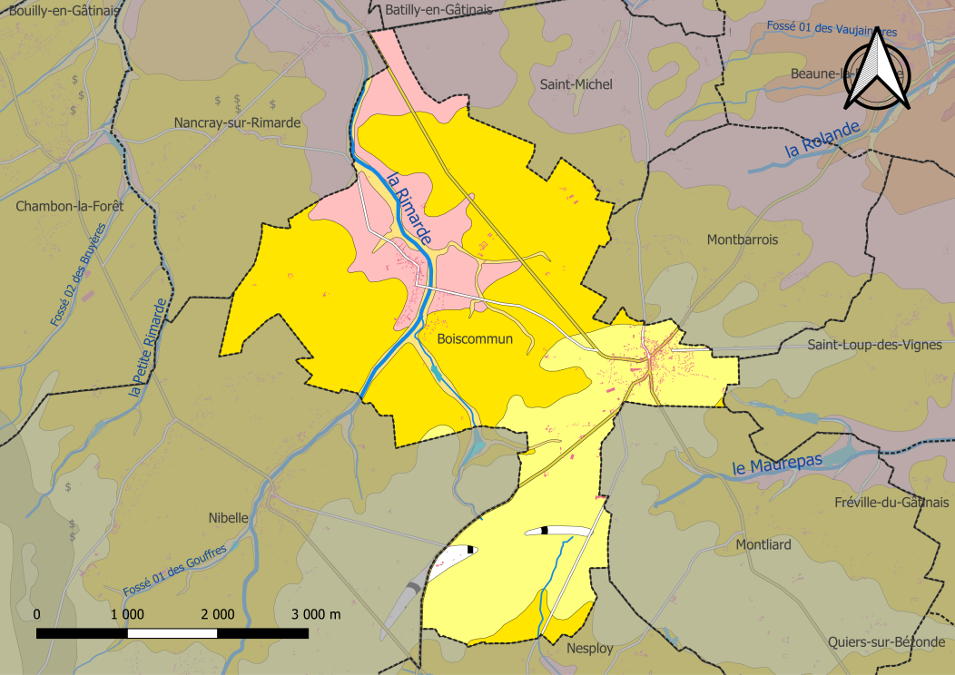
Français : Carte du zonage géologique de la commune de la commune de fr:Boiscommun (France). |
| Date | |
| Source |
Travail personnel avec les données : * Découpage administratif communal et départemental : Export simple de janvier 2020 - vérifié et simplifié à 5 m sur le site du portail de données libres du gouvernement français, élaboré avec le concours des contributeurs à OpenStreetMap * Réseau routier : : Export openstreetmap de Geofabrik- version du 29 juin 2019 * Cours d'eau : Cours d'eau - Métropole - BD Carthage 2017 * zonage géologique : cartes géologiques départementales à 1/50 000 (Bd Charm-50) Assemblé et enrichi dans fr:QGis. |
| Auteur | Roland45 |
Conditions d’utilisation
[modifier]
Moi, en tant que détenteur des droits d’auteur sur cette œuvre, je la publie sous la licence suivante :
Ce fichier est sous la licence Creative Commons Attribution – Partage dans les Mêmes Conditions 4.0 International.
- Vous êtes libre :
- de partager – de copier, distribuer et transmettre cette œuvre
- d’adapter – de modifier cette œuvre
- Sous les conditions suivantes :
- paternité – Vous devez donner les informations appropriées concernant l'auteur, fournir un lien vers la licence et indiquer si des modifications ont été faites. Vous pouvez faire cela par tout moyen raisonnable, mais en aucune façon suggérant que l’auteur vous soutient ou approuve l’utilisation que vous en faites.
- partage à l’identique – Si vous modifiez, transformez, ou vous basez sur cette œuvre, vous devez distribuer votre contribution sous la même licence ou une licence compatible avec celle de l’original.
Historique du fichier
Cliquer sur une date et heure pour voir le fichier tel qu'il était à ce moment-là.
| Date et heure | Vignette | Dimensions | Utilisateur | Commentaire | |
|---|---|---|---|---|---|
| actuel | 25 mai 2022 à 13:40 | | 1 052 × 744 (2,81 Mio) | Roland45 (d | contributions) | pattypan 22.03 |
Vous ne pouvez pas remplacer ce fichier.
Utilisations locales du fichier
Aucune page n’utilise ce fichier.
Utilisations du fichier sur d’autres wikis
Les autres wikis suivants utilisent ce fichier :
- Utilisation sur fr.wikipedia.org
Métadonnées
Catégories :
- Geological maps of Boiscommun (Loiret)
- Geological maps of Nibelle
- Geological maps of Chambon-la-Forêt
- Geological maps of Nancray-sur-Rimarde
- Geological maps of Saint-Michel (Loiret)
- Geological maps of Saint-Loup-des-Vignes
- Geological maps of Montliard
- Sables et argiles de Sologne (Langhian - Pliocène; Loiret) - maps
- Marnes et sables de l'Orléanais (Burdigalian; Loiret) - maps
- Marne de Blamont (Aquitanian; Loiret) - maps
- Holocene alluvium in Loiret - maps
- Holocene colluvium in Loiret - maps