File:A15 PSR Fig 5-56 Planimetric map Station 1.jpg
跳转到导航
跳转到搜索
没有更高的分辨率。
A15_PSR_Fig_5-56_Planimetric_map_Station_1.jpg (442 × 258像素,文件大小:26 KB,MIME类型:image/jpeg)
说明
说明
添加一行文字以描述该文件所表现的内容
摘要
[编辑]
| 描述 |
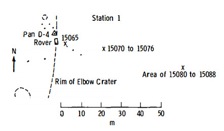
English: Figure 5-56 (edited slightly). Planimetric map of Apollo 15 Geology Station 1.
X indicates sample locations, 5-digit numbers are LRL sample numbers, rectangle is lunar rover (dot indicates TV camera), black spots are large rocks, dashed lines are crater rims or other topographic features, and triangles are panorama stations. |
| 日期 | |
| 来源 | Apollo 15 Preliminary Science Report, 1972, NASA SP-289, Scientific and Technical Information Office, National Aeronautics and Space Administration, Washington, D.C. [1] |
| 作者 | NASA |
许可协议
[编辑]
| 本文件完全由NASA创作,在美国属于公有领域。根据NASA的版权方针,NASA的材料除非另有声明否则不受版权保护。(参见Template:PD-USGov/zh、NASA版权方针页面或JPL图片使用方针。) | ||
 |
警告:
|
文件历史
点击某个日期/时间查看对应时刻的文件。
| 日期/时间 | 缩略图 | 大小 | 用户 | 备注 | |
|---|---|---|---|---|---|
| 当前 | 2016年8月29日 (一) 01:45 | | 442 × 258(26 KB) | Jstuby(留言 | 贡献) | User created page with UploadWizard |
您不可以覆盖此文件。
文件用途
全域文件用途
以下其他wiki使用此文件:
- en.wikipedia.org上的用途
- es.wikipedia.org上的用途
- zh.wikipedia.org上的用途