File:ACW Chattanooga2Carolinas.png
Aller à la navigation
Aller à la recherche
Taille de cet aperçu : 800 × 426 pixels. Autres résolutions : 320 × 170 pixels | 640 × 341 pixels | 1 024 × 545 pixels | 1 881 × 1 002 pixels.
Fichier d’origine (1 881 × 1 002 pixels, taille du fichier : 429 kio, type MIME : image/png)
Légendes
Légendes
Ajoutez en une ligne la description de ce que représente ce fichier
Description
[modifier]| Description |
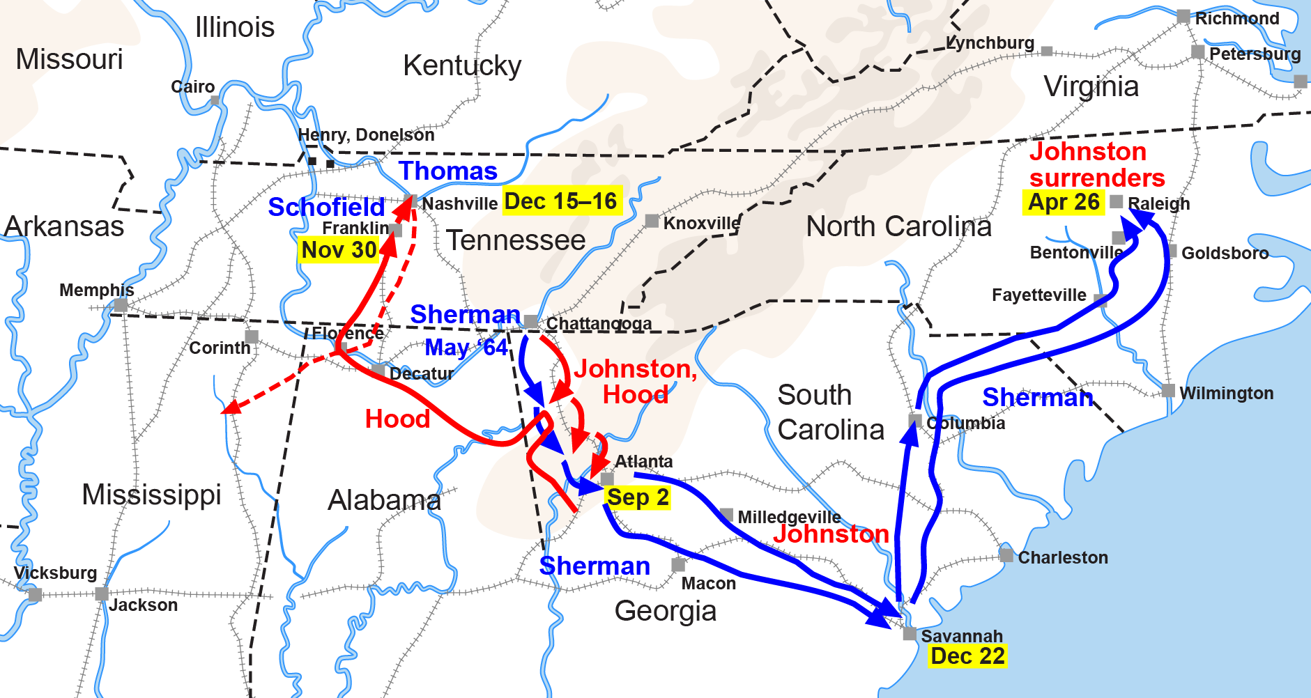
English: Map of the Western Theater of the American Civil War, actions from Chattanooga to the Carolinas. |
| Date | |
| Source | Drawn by Hal Jespersen in Adobe Illustrator CS5. Graphic source file is available at http://www.posix.com/CWmaps/ |
| Auteur | Hlj sur Wikipédia anglais |
| Autres versions |
|


Conditions d’utilisation
[modifier]
Ce fichier est disponible selon les termes de la licence Creative Commons Attribution 3.0 Non transposée.
Attribution: Map by Hal Jespersen, www.posix.com/CW
- Vous êtes libre :
- de partager – de copier, distribuer et transmettre cette œuvre
- d’adapter – de modifier cette œuvre
- Sous les conditions suivantes :
- paternité – Vous devez donner les informations appropriées concernant l'auteur, fournir un lien vers la licence et indiquer si des modifications ont été faites. Vous pouvez faire cela par tout moyen raisonnable, mais en aucune façon suggérant que l’auteur vous soutient ou approuve l’utilisation que vous en faites.
Journal des téléversements d’origine
[modifier]
Transféré de it.wikipedia à Commons par MaEr.
La page de description originale était ici. Tous les noms d'utilisateur qui suivent se rapportent à it.wikipedia.
- 2006-10-06 17:12 Starlight 1566×773×??? (316548 bytes) Map of the Western Theater of the American Civil War, actions from Chattanooga to the Carolinas. Drawn by Hal Jespersen in Macromedia Freehand. Graphic source file is available at http://www.posix.com/CWmaps/ {{PD}}
La page de description originale était ici. Tous les noms d'utilisateur qui suivent se rapportent à en.wikipedia.
- 2006-03-31 00:30 Hlj 1566×773× (316548 bytes) Map of the [[Western Theater of the American Civil War]], actions from Chattanooga to the Carolinas. Drawn by Hal Jespersen in Macromedia Freehand. Graphic source file is available at http://www.posix.com/CWmaps/ {{PD-release}}
Historique du fichier
Cliquer sur une date et heure pour voir le fichier tel qu'il était à ce moment-là.
| Date et heure | Vignette | Dimensions | Utilisateur | Commentaire | |
|---|---|---|---|---|---|
| actuel | 24 mars 2011 à 22:35 | | 1 881 × 1 002 (429 kio) | Hlj (d | contributions) | Update to new graphical style for rivers. Same license. |
| 6 février 2009 à 05:34 |  | 1 862 × 992 (309 kio) | Hlj (d | contributions) | {{Information |Description=Map of Sherman's operations from Chattanooga through the Carolinas of the American Civil War. (Minor updates from previous version; new license.) Drawn in Adobe Illustrator CS3 by Hal Jespersen. Graphic source file is availa | |
| 14 septembre 2008 à 11:50 |  | 1 566 × 773 (309 kio) | MaEr (d | contributions) | {{Information |Description={{en|Map of the Western Theater of the American Civil War, actions from Chattanooga to the Carolinas. Drawn by Hal Jespersen in Macromedia Freehand. Graphic source file is available at http://www.posix.com/CWmaps/}} |Source=Tran |
Vous ne pouvez pas remplacer ce fichier.
Utilisations locales du fichier
Les 5 pages suivantes utilisent ce fichier :
Utilisations du fichier sur d’autres wikis
Les autres wikis suivants utilisent ce fichier :
- Utilisation sur en.wikipedia.org
- Utilisation sur fr.wikipedia.org
- Utilisation sur it.wikipedia.org
- Utilisation sur ja.wikipedia.org
- Utilisation sur ru.wikipedia.org
- Utilisation sur uk.wikipedia.org