File:AMH-4740-NA Map of Poeloe Run.jpg
Aller à la navigation
Aller à la recherche

Taille de cet aperçu : 800 × 590 pixels. Autres résolutions : 320 × 236 pixels | 640 × 472 pixels | 1 024 × 755 pixels | 1 280 × 944 pixels | 2 400 × 1 770 pixels.
Fichier d’origine (2 400 × 1 770 pixels, taille du fichier : 882 kio, type MIME : image/jpeg)
Légendes
Légendes
Ajoutez en une ligne la description de ce que représente ce fichier
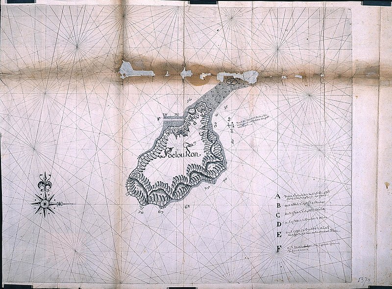
Map of Pulau Ron
Description
[modifier]Nederlands: Plattegrond van Poeloe Run
                     English:  Map of Poeloe Run
                     Bahasa Indonesia:  Peta Pulau Ron
( |
||||||||||||||||||||||||
|---|---|---|---|---|---|---|---|---|---|---|---|---|---|---|---|---|---|---|---|---|---|---|---|---|
| Auteur |
Creator:Batavia 1623 kaartenmaker Nederlands: Batavia 1623 kaartenmaker (landmeter / kaartenmaker)
English: Batavia 1623 kaartenmaker (land surveyor / mapmaker) |
|||||||||||||||||||||||
| Titre |
Nederlands: Plattegrond van Poeloe Run
English: Map of Poeloe Run
Bahasa Indonesia: Peta Pulau Ron |
|||||||||||||||||||||||
| Description |
Nederlands: Titel catalogus Leupe (NA): Afteeckening van 't eiland Puleron.
Notities verso: affteeckening van t'eylant Puleron / 664 c.
English: According to the Leupe catalogue (NA), the original title reads: Afteeckening van 't eiland Puleron.
Notes on reverse: affteeckening van t'eylant Puleron / 664 c.
Bahasa Indonesia: Menurut katalog Leupe (NA), judul aslinya berbunyi: Afteeckening van 't eiland Puleron.
Catatan di belakang: affteeckening van t'eylant Puleron / 664 c. |
|||||||||||||||||||||||
| Date | vers 1623 | |||||||||||||||||||||||
| Technique / matériaux |
Nederlands: pen op papier
English: pen on paper
Bahasa Indonesia: pulpen di atas kertas |
|||||||||||||||||||||||
| Dimensions | hauteur : 63 cm ; largeur : 46 cm | |||||||||||||||||||||||
| Collection |
|
|||||||||||||||||||||||
| Numéro d’inventaire |
NL-HaNA_4.VEL_1370B (old number: VEL1370B) |
|||||||||||||||||||||||
| Inscriptions |
Poelou Ron
|
|||||||||||||||||||||||
| Notes |
English: Subjects: chart / map / plan, key, building, compass / dial
Nederlands: Onderwerpen: plattegrond / kaart, legenda, gebouw, kompas / windroos
English: Post: this image is related to a VOC trading post called Run |
|||||||||||||||||||||||
| Source / photographe |
|
|||||||||||||||||||||||
| Autorisation (Réutilisation de ce fichier) |
|
|||||||||||||||||||||||

| Position de l'objet | | Voir cet endroit et d’autres images sur : OpenStreetMap |
|---|
Historique du fichier
Cliquer sur une date et heure pour voir le fichier tel qu'il était à ce moment-là.
| Date et heure | Vignette | Dimensions | Utilisateur | Commentaire | |
|---|---|---|---|---|---|
| actuel | 10 juin 2014 à 17:11 | | 2 400 × 1 770 (882 kio) | HuskyBot (d | contributions) | == {{int:filedesc}} == {{Artwork |title = {{nl|1=Plattegrond van Poeloe Run}} {{en|1=Map of Poeloe Run}} |description = {{nl|1=Titel catalogus Leupe (NA): ''Afteeckening van 't eiland Puleron''. Notities verso... |
Vous ne pouvez pas remplacer ce fichier.
Utilisations locales du fichier
La page suivante utilise ce fichier :
Utilisations du fichier sur d’autres wikis
Les autres wikis suivants utilisent ce fichier :
- Utilisation sur en.wikipedia.org
- Utilisation sur fr.wikipedia.org
- Utilisation sur id.wikipedia.org
- Utilisation sur nl.wikipedia.org