File:AMH-7734-NA Floor plan of Fort Goede Hoop in Bercou.jpg
Fichier d’origine (2 400 × 1 862 pixels, taille du fichier : 350 kio, type MIME : image/jpeg)
Légendes
Légendes
Description[modifier]
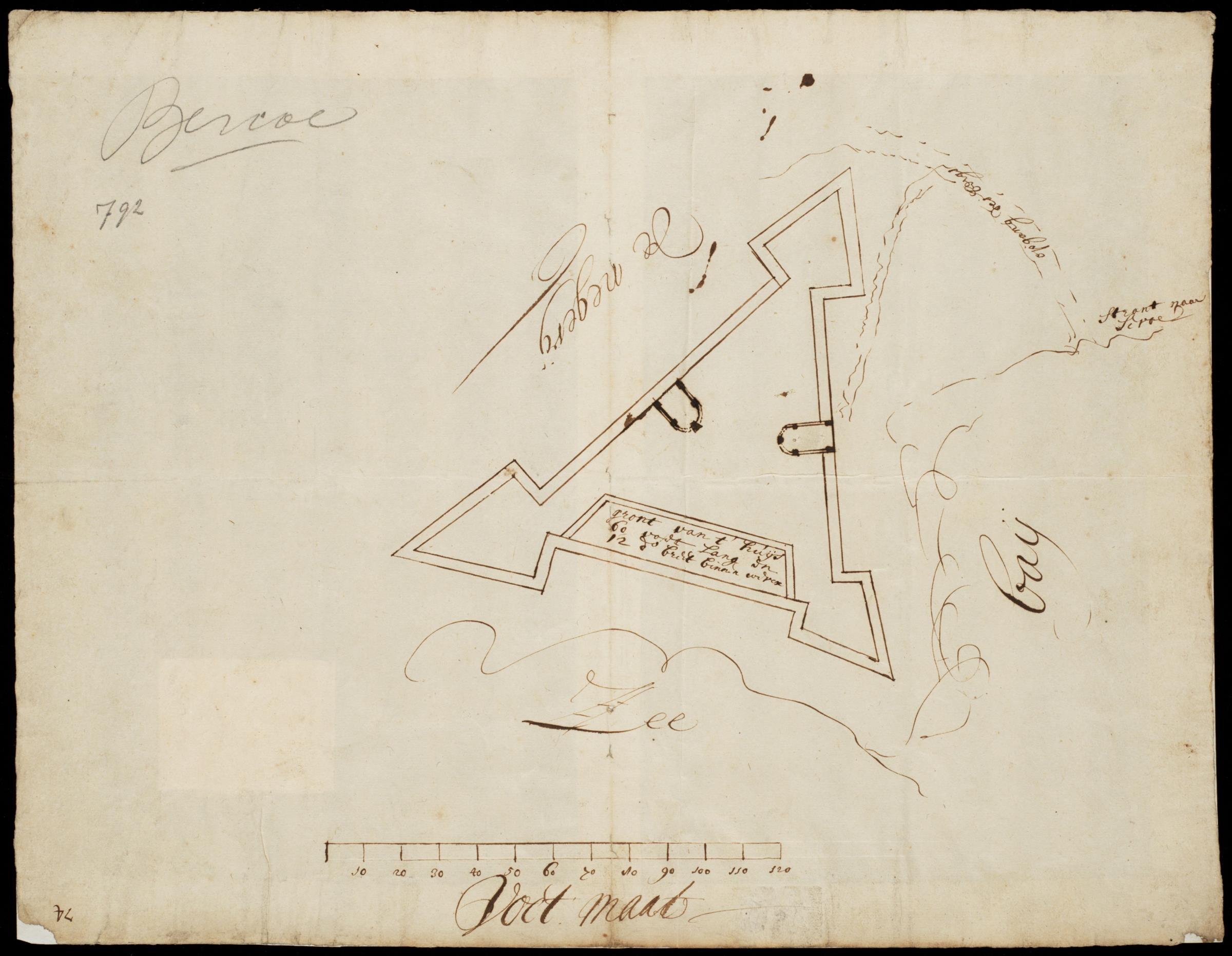
Nederlands: Plattegrond van het fort Goede Hoop in Bercou
English: Floor plan of Fort Goede Hoop in Bercou( |
||||||||||||||||||||||||
|---|---|---|---|---|---|---|---|---|---|---|---|---|---|---|---|---|---|---|---|---|---|---|---|---|
| Auteur |
Nederlands: Anoniem / Anonymous (landmeter / kaartenmaker)
English: Anoniem / Anonymous (land surveyor / mapmaker) |
|||||||||||||||||||||||
| Titre |
Nederlands: Plattegrond van het fort Goede Hoop in Bercou
English: Floor plan of Fort Goede Hoop in Bercou |
|||||||||||||||||||||||
| Description |
Nederlands: Plattegrond van het fort Goede Hoop in Bercou.
Titel catalogus Leupe (NA): Plan van Fort Goede Hoop tot Bercoe. gront van t'huijs 60 voet lang en 12 vt: breet binnen werck. Rechtsboven: 792 / Bercoe [in potlood]. Rechtsboven genummerd 74, dat moet het folionummer in de band zjin. De beschrijving in de inventaris Leupe heeft betrekking op VEL 791. Notities verso: N 518a / 73 [in potlood, folionummer in de band ?]. Linksonder: 74.English: Floor plan of Fort Goede Hoop in Bercou.
Title in the Leupe catalogue (NA): Plan van Fort Goede Hoop tot Bercoe. gront van t'huijs 60 voet lang en 12 vt: breet binnen werck. Top right: 792 / Bercoe [in pencil]. Numbered top right 74, presumed to be the folio number in the volume. The description in the Leupe inventory pertains to VEL 791. Notes on reverse: N 518a / 73 [in pencil, folio number in the volume ?]. Bottom left: 74. |
|||||||||||||||||||||||
| Date | entre 1700 et 1800 | |||||||||||||||||||||||
| Technique / matériaux |
Nederlands: pen op papier
English: pen on paper |
|||||||||||||||||||||||
| Dimensions | hauteur : 41,5 cm ; largeur : 32,5 cm | |||||||||||||||||||||||
| Collection |
|
|||||||||||||||||||||||
| Numéro d’inventaire |
NL-HaNA_4.VEL_792 (old number: VEL0792) |
|||||||||||||||||||||||
| Notes |
English: Subjects: fortification, chart / map / plan
Nederlands: Onderwerpen: vesting, plattegrond / kaart |
|||||||||||||||||||||||
| Source / photographe |
|
|||||||||||||||||||||||
| Autorisation (Réutilisation de ce fichier) |
|
|||||||||||||||||||||||

| Position de l'objet | | Voir cet endroit et d’autres images sur : OpenStreetMap |
|---|
Historique du fichier
Cliquer sur une date et heure pour voir le fichier tel qu'il était à ce moment-là.
| Date et heure | Vignette | Dimensions | Utilisateur | Commentaire | |
|---|---|---|---|---|---|
| actuel | 11 juin 2014 à 10:16 | | 2 400 × 1 862 (350 kio) | HuskyBot (d | contributions) | == {{int:filedesc}} == {{Artwork |title = {{nl|1=Plattegrond van het fort Goede Hoop in Bercou}} {{en|1=Floor plan of Fort Goede Hoop in Bercou}} |description = {{nl|1=Plattegrond van het fort Goede Hoop in Ber... |
Vous ne pouvez pas remplacer ce fichier.
Utilisations locales du fichier
La page suivante utilise ce fichier :
Utilisations du fichier sur d’autres wikis
Les autres wikis suivants utilisent ce fichier :
- Utilisation sur fr.wikipedia.org