File:ASTER Richat.jpg
Aller à la navigation
Aller à la recherche

Taille de cet aperçu : 635 × 599 pixels. Autres résolutions : 254 × 240 pixels | 509 × 480 pixels | 814 × 768 pixels | 1 085 × 1 024 pixels | 2 171 × 2 048 pixels | 3 130 × 2 953 pixels.
Fichier d’origine (3 130 × 2 953 pixels, taille du fichier : 1,84 Mio, type MIME : image/jpeg)
Légendes
Légendes
Ajoutez en une ligne la description de ce que représente ce fichier
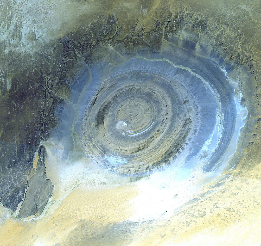
Richat Structure, Oudane, Mauritania
Description
[modifier]
| Description |
English: Richat Structure, Oudane, Mauritania - This prominent circular feature in the Sahara desert of Mauritania has attracted attention since the earliest space missions because it forms a conspicuous bull's-eye in the otherwise rather featureless expanse of the desert. Described by some as looking like an outsized ammonite in the desert, the structure [which has a diameter of almost 50 kilometers (30 miles)] has become a landmark for shuttle crews. Initially interpreted as a meteorite impact structure because of its high degree of circularity, it is now thought to be merely a symmetrical uplift (circular anticline) that has been laid bare by erosion. Paleozoic quartzites form the resistant beds outlining the structure. The image was acquired October 7, 2000, covers an area of 45 x 47 km, and is located at 20.9 degrees north latitude and 11.6 degrees west longitude. |
| Date | Prise le 7 octobre 2000 |
| Source | https://asterweb.jpl.nasa.gov/gallery-detail.asp?name=Richat |
| Auteur | NASA/GSFC/MITI/ERSDAC/JAROS, and U.S./Japan ASTER Science Team |
| Autorisation (Réutilisation de ce fichier) |
”The purpose of NASA's Earth Observatory is to provide a freely-accessible publication on the Internet where the public can obtain new satellite imagery and scientific information about our home planet. The focus is on Earth's climate and environmental change. In particular, we hope our site is useful to public media and educators. Any and all materials published on the Earth Observatory are freely available for re-publication or re-use, except where copyright is indicated. We ask that NASA's Earth Observatory be given credit for its original materials.” |
Conditions d’utilisation
[modifier]
| Ce fichier provient de la NASA. Sauf exception, les documents créés par la NASA ne sont pas soumis à copyright. Pour plus d'informations, voir la politique de copyright de la NASA. | ||
 |
Attention :
|
Journal des téléversements d’origine
[modifier]
La page de description originale était ici. Tous les noms d'utilisateur qui suivent se rapportent à en.wikipedia.
- 2006-04-05 12:43 Brian0918 3130×2953×8 (1928719 bytes)
- 2006-04-05 12:34 Brian0918 3130×2953×8 (1518916 bytes) '''Credit(s):''' NASA/GSFC/MITI/ERSDAC/JAROS, and U.S./Japan [http://asterweb.jpl.nasa.gov/ ASTER Science Team] '''Source:''' http://asterweb.jpl.nasa.gov/gallery-detail.asp?name=Richat ''”The purpose of NASA's Earth Observatory is to provide a fr
Historique du fichier
Cliquer sur une date et heure pour voir le fichier tel qu'il était à ce moment-là.
| Date et heure | Vignette | Dimensions | Utilisateur | Commentaire | |
|---|---|---|---|---|---|
| actuel | 26 octobre 2007 à 05:32 | | 3 130 × 2 953 (1,84 Mio) | File Upload Bot (Magnus Manske) (d | contributions) | {{BotMoveToCommons|en.wikipedia}} {{Information |Description='''Credit(s):''' NASA/GSFC/MITI/ERSDAC/JAROS, and U.S./Japan [http://asterweb.jpl.nasa.gov/ ASTER Science Team] '''Source:''' http://asterweb.jpl.nasa.gov/gallery-detail.asp?name=Richat '' |
Vous ne pouvez pas remplacer ce fichier.
Utilisations locales du fichier
Les 3 pages suivantes utilisent ce fichier :
- File:Eye of Sahara LAPAN A3.jpg (redirection de fichier)
- Category:Natural domes
- Category:Richat Structure
Utilisations du fichier sur d’autres wikis
Les autres wikis suivants utilisent ce fichier :
- Utilisation sur ar.wikipedia.org
- Utilisation sur be.wikipedia.org
- Utilisation sur bg.wikipedia.org
- Utilisation sur bn.wikipedia.org
- Utilisation sur ca.wikipedia.org
- Utilisation sur de.wikipedia.org
- Utilisation sur de.wikivoyage.org
- Utilisation sur en.wikipedia.org
- Utilisation sur eo.wikipedia.org
- Utilisation sur es.wikipedia.org
- Utilisation sur fa.wikipedia.org
- Utilisation sur fr.wikipedia.org
- Utilisation sur gl.wikipedia.org
- Utilisation sur ha.wikipedia.org
- Utilisation sur he.wikipedia.org
- Utilisation sur hu.wikipedia.org
- Utilisation sur hy.wikipedia.org
- Utilisation sur id.wikipedia.org
- Utilisation sur ig.wikipedia.org
- Utilisation sur it.wikipedia.org
- Utilisation sur jam.wikipedia.org
- Utilisation sur ja.wikipedia.org
- Utilisation sur ka.wikipedia.org
- Utilisation sur ko.wikipedia.org
- Utilisation sur li.wikipedia.org
- Utilisation sur lt.wikipedia.org
- Utilisation sur nl.wikipedia.org
- Utilisation sur nn.wikipedia.org
- Utilisation sur pl.wikipedia.org
- Utilisation sur pt.wikipedia.org
Voir davantage sur l’utilisation globale de ce fichier.