File:AYool SEAWIFS annual.png
跳至導覽
跳至搜尋

預覽大小:800 × 544 像素。 其他解析度:320 × 217 像素 | 640 × 435 像素 | 1,024 × 696 像素 | 1,280 × 870 像素 | 1,667 × 1,133 像素。
原始檔案 (1,667 × 1,133 像素,檔案大小:453 KB,MIME 類型:image/png)
說明
說明
添加單行說明來描述出檔案所代表的內容
摘要
[編輯]
| 描述 |
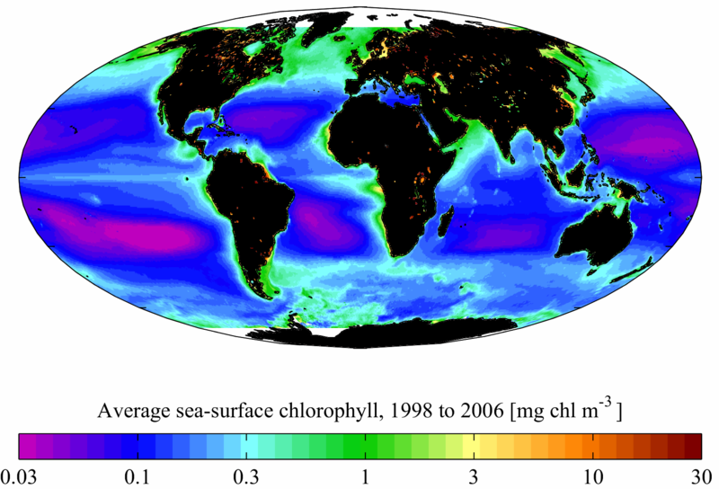
English: Average sea surface chlorophyll for the period January 1998 to December 2006 from the SeaWIFS satellite. The average is composed from 8 day composites with a spatial resolution of 0.5° in latitude and longitude. Chlorophyll is in mg chl m-3 (note that the colour scale is logarithmic). It is plotted here using a Mollweide projection (using MATLAB and the M_Map package).
Français : teneur moyenne des eaux de surface en chlorophylle a, pour la période 1998-2006 ; Attention l'échelle est logarithmique |
| 日期 | |
| 來源 | 自己的作品 (Original text: self-made) |
| 作者 | Plumbago (talk) |
授權條款
[編輯]
此檔案採用共享創意 姓名標示-相同方式分享 3.0 未在地化版本授權條款。
- 您可以自由:
- 分享 – 複製、發佈和傳播本作品
- 重新修改 – 創作演繹作品
- 惟需遵照下列條件:
- 姓名標示 – 您必須指名出正確的製作者,和提供授權條款的連結,以及表示是否有對內容上做出變更。您可以用任何合理的方式來行動,但不得以任何方式表明授權條款是對您許可或是由您所使用。
- 相同方式分享 – 如果您利用本素材進行再混合、轉換或創作,您必須基於如同原先的相同或兼容的條款,來分布您的貢獻成品。

|
已授權您依據自由軟體基金會發行的無固定段落、封面文字和封底文字GNU自由文件授權條款1.2版或任意後續版本,對本檔進行複製、傳播和/或修改。該協議的副本列在GNU自由文件授權條款中。 |
您可以選擇您需要的授權條款。
原始上傳日誌
[編輯]
The original description page was here. All following user names refer to en.wikipedia.
- 2008-04-01 13:53 Plumbago 1667×1133× (558075 bytes) {{Information |Description=Average sea surface [[chlorophyll]] for the period January 1998 to December 2006 from the [[SeaWIFS]] [[satellite]]. The average is composed from 8 day [[Digital compositing|composites]]. Chlorophyll here is in [[Gram#SI multi
檔案歷史
點選日期/時間以檢視該時間的檔案版本。
| 日期/時間 | 縮圖 | 尺寸 | 用戶 | 備註 | |
|---|---|---|---|---|---|
| 目前 | 2014年8月12日 (二) 11:28 | | 1,667 × 1,133(453 KB) | LlywelynII(對話 | 貢獻) | Unhelpful white landforms to black: all remaining coastal or inland artifacts present in original, some obviously displaying lakes. Non-included seas in Arctic and Antarctic left white. |
| 2009年2月10日 (二) 20:45 |  | 1,667 × 1,133(545 KB) | Lamiot(對話 | 貢獻) | {{Information |Description={{en|Average sea surface chlorophyll for the period January 1998 to December 2006 from the SeaWIFS satellite. The average is composed from 8 day composites with a spatial resolution of 0.5° in latitude and longitude. Chlorophyl |
無法覆蓋此檔案。
檔案用途
沒有使用此檔案的頁面。
全域檔案使用狀況
以下其他 wiki 使用了這個檔案:
- ar.wikipedia.org 的使用狀況
- ba.wikipedia.org 的使用狀況
- bg.wikipedia.org 的使用狀況
- bn.wikipedia.org 的使用狀況
- de.wikipedia.org 的使用狀況
- en.wikipedia.org 的使用狀況
- fa.wikipedia.org 的使用狀況
- fr.wikipedia.org 的使用狀況
- gu.wikipedia.org 的使用狀況
- he.wikipedia.org 的使用狀況
- kn.wikipedia.org 的使用狀況
- pl.wikipedia.org 的使用狀況
- pt.wikipedia.org 的使用狀況
- ru.wikipedia.org 的使用狀況
- simple.wikipedia.org 的使用狀況
- ta.wikipedia.org 的使用狀況
- te.wikipedia.org 的使用狀況
- uk.wikipedia.org 的使用狀況
- zh.wikipedia.org 的使用狀況