File:Abbasids850.png
出自Wikimedia Commons
跳至導覽
跳至搜尋

預覽大小:800 × 487 像素。 其他解析度:320 × 195 像素 | 640 × 390 像素 | 1,024 × 624 像素 | 1,481 × 902 像素。
原始檔案 (1,481 × 902 像素,檔案大小:50 KB,MIME 類型:image/png)
檔案資訊
結構化資料
說明
說明
添加單行說明來描述出檔案所代表的內容
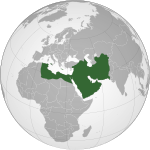
نقشه خلافت عباسی در بزرگترین گستره آن، ۸۵۰م. (تا حدی بر اساس اطلس تاریخ جهان (۲۰۰۷) - پیشرفت اسلام، نقشه)
خريطة الدولة العباسية في أقصى اتساعها.
摘要
[編輯]| 描述Abbasids850.png |
English: Map of the Abbasid Caliphate at its greatest extent, c. 850.
(Partially based on Atlas of World History (2007) - Progress of Islam, map)
العربية: :خريطة الدولة العباسية في أقصى اتساعها. |
| 日期 | |
| 來源 | 自己的作品 |
| 作者 | Gabagool |
| 其他版本 | Derivative works of this file: IslamicWorld850.png |

|
File:Abbassids 850 (orthographic projection).svg是本檔案的向量版本。 如果品質不低,就應該優先使用該檔案,而非PNG檔案。
File:Abbasids850.png → File:Abbassids 850 (orthographic projection).svg
更多資訊請參閱Help:SVG/zh。
|
授權條款
[編輯]我,本作品的著作權持有者,決定用以下授權條款發佈本作品:
此檔案採用創用CC 姓名標示 3.0 未在地化版本授權條款。
- 您可以自由:
- 分享 – 複製、發佈和傳播本作品
- 重新修改 – 創作演繹作品
- 惟需遵照下列條件:
- 姓名標示 – 您必須指名出正確的製作者,和提供授權條款的連結,以及表示是否有對內容上做出變更。您可以用任何合理的方式來行動,但不得以任何方式表明授權條款是對您許可或是由您所使用。
檔案歷史
點選日期/時間以檢視該時間的檔案版本。
| 日期/時間 | 縮圖 | 尺寸 | 用戶 | 備註 | |
|---|---|---|---|---|---|
| 目前 | 2012年3月25日 (日) 10:42 |  | 1,481 × 902(50 KB) | Cplakidas(對話 | 貢獻) | corrections: the eastern half of Sicily was still in Byz. hands, as was Malta. Sardinia and Corsica were raided but never conquered |
| 2009年4月22日 (三) 15:28 |  | 1,481 × 902(50 KB) | Gabagool(對話 | 貢獻) | some corrections.. | |
| 2009年4月21日 (二) 16:28 |  | 1,481 × 902(50 KB) | Gabagool(對話 | 貢獻) | {{Information |Description={{en|1=Map of the Abbasid Caliphat at its greatest extent, c. 850. (Partially based on ''Atlas of World History'' (2007) - Progress of Islam, map)}} |Source=Own work by uploader |Author=Gabagool / Jarle Grøhn |
無法覆蓋此檔案。
檔案用途
下列2個頁面有用到此檔案:
全域檔案使用狀況
以下其他 wiki 使用了這個檔案:
- af.wikipedia.org 的使用狀況
- als.wikipedia.org 的使用狀況
- an.wikipedia.org 的使用狀況
- ar.wikipedia.org 的使用狀況
- arz.wikipedia.org 的使用狀況
- ast.wikipedia.org 的使用狀況
- azb.wikipedia.org 的使用狀況
- bat-smg.wikipedia.org 的使用狀況
- be-tarask.wikipedia.org 的使用狀況
- be.wikipedia.org 的使用狀況
- bg.wikipedia.org 的使用狀況
- bn.wikipedia.org 的使用狀況
- br.wikipedia.org 的使用狀況
- bs.wikipedia.org 的使用狀況
- bxr.wikipedia.org 的使用狀況
- ca.wikipedia.org 的使用狀況
- cbk-zam.wikipedia.org 的使用狀況
- ckb.wikipedia.org 的使用狀況
- cs.wikipedia.org 的使用狀況
- da.wikipedia.org 的使用狀況
- de.wikipedia.org 的使用狀況
- diq.wikipedia.org 的使用狀況
- en.wikipedia.org 的使用狀況
檢視此檔案的更多全域使用狀況。
