File:Abele dec 1 2010.jpg
Zur Navigation springen
Zur Suche springen
Größe dieser Vorschau: 466 × 599 Pixel. Weitere Auflösungen: 187 × 240 Pixel | 373 × 480 Pixel | 597 × 768 Pixel | 796 × 1.024 Pixel | 1.593 × 2.048 Pixel | 5.600 × 7.200 Pixel.
Originaldatei (5.600 × 7.200 Pixel, Dateigröße: 5,62 MB, MIME-Typ: image/jpeg)
Bildtexte
Kurzbeschreibungen
Ergänze eine einzeilige Erklärung, was diese Datei darstellt.
Beschreibung[Bearbeiten]
| Beschreibung |
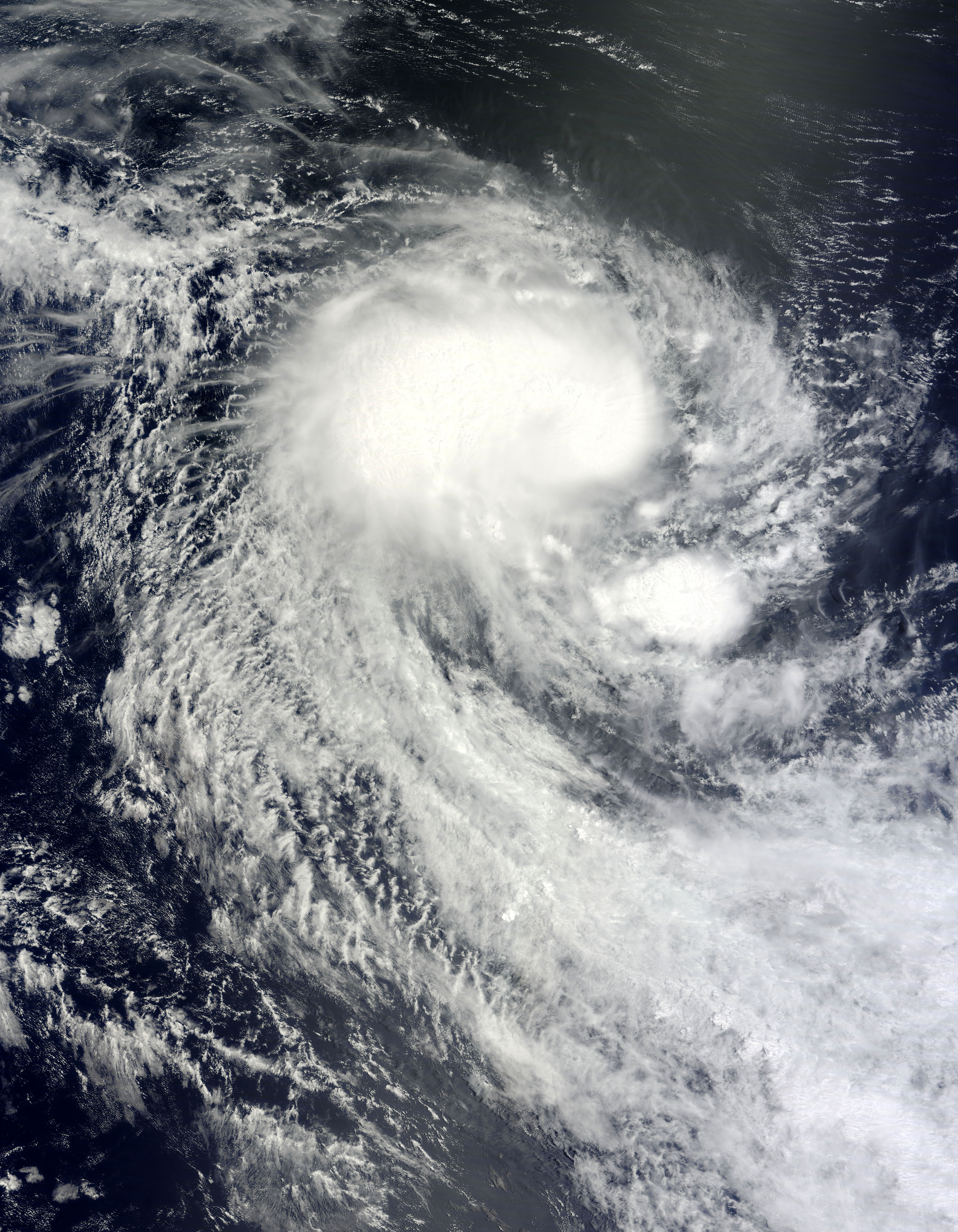
English: On November 30, 2010, the 2010 Atlantic hurricane season came to a close, but tropical cyclones are a global phenomenon, and it’s always cyclone season somewhere. On November 29, 2010, Tropical Cyclone Abele formed over the southern Indian Ocean. On December 1, 2010, the U.S. Navy’s Joint Typhoon Warning Center reported that Abele had maximum sustained winds of 40 knots (75 kilometers per hour) with gusts up to 50 knots (95 kilometers per hour). The storm was located some 675 nautical miles (1,250 kilometers) west-southwest of Cocos Island, Australia.
The Moderate Resolution Imaging Spectroradiometer (MODIS) on NASA’s Terra satellite captured this natural-color image of Abele on December 1, 2010. Abele spans hundreds of kilometers over the open ocean. The storm lacks a distinct eye, but sports the apostrophe shape characteristic of tropical cyclones. Over the past two centuries, tropical cyclones have killed nearly two million people, and forecasters worldwide continually strive to improve storm forecasts. In less developed parts of the globe, a dearth of data has historically hampered predictions. A new tool in forecasters’s arsenal, however, is the Pleiades supercomputer at NASA’s Ames Research Center. Relying on Pleiades’ computing muscle, researchers have been able to model storm formation by feeding the computer data about wind speed, temperature, and mositure. In the case of Cyclone Nargis, which struck in 2008, researchers were able to replicate the tropical cyclone’s formation five days in advance. The project offered hope for improving future predictions worldwide. |
| Datum | |
| Quelle | http://earthobservatory.nasa.gov/NaturalHazards/view.php?id=47492 |
| Urheber | NASA image courtesy Jeff Schmaltz, MODIS Rapid Response Team at NASA GSFC. Caption by Michon Scott. |
Lizenz[Bearbeiten]
| Diese Datei ist gemeinfrei (public domain), da sie von der NASA erstellt worden ist. Die NASA-Urheberrechtsrichtlinie besagt, dass „NASA-Material nicht durch Urheberrecht geschützt ist, wenn es nicht anders angegeben ist“. (NASA-Urheberrechtsrichtlinie-Seite oder JPL Image Use Policy). | ||
 |
Warnung:
|
Dateiversionen
Klicke auf einen Zeitpunkt, um diese Version zu laden.
| Version vom | Vorschaubild | Maße | Benutzer | Kommentar | |
|---|---|---|---|---|---|
| aktuell | 23:58, 1. Dez. 2010 | | 5.600 × 7.200 (5,62 MB) | Supportstorm (Diskussion | Beiträge) | {{Information |Description={{en|1=On November 30, 2010, the 2010 Atlantic hurricane season came to a close, but tropical cyclones are a global phenomenon, and it’s always cyclone season somewhere. On November 29, 2010, Tropical Cyclone Abele formed over |
Du kannst diese Datei nicht überschreiben.
Dateiverwendung
Keine Seiten verwenden diese Datei.
Globale Dateiverwendung
Die nachfolgenden anderen Wikis verwenden diese Datei:
- Verwendung auf de.wikipedia.org
- Verwendung auf zh.wikipedia.org