File:Abele dec 1 2010.jpg
跳转到导航
跳转到搜索
本预览的尺寸:466 × 599像素。 其他分辨率:187 × 240像素 | 373 × 480像素 | 597 × 768像素 | 796 × 1,024像素 | 1,593 × 2,048像素 | 5,600 × 7,200像素。
原始文件 (5,600 × 7,200像素,文件大小:5.62 MB,MIME类型:image/jpeg)
说明
说明
添加一行文字以描述该文件所表现的内容
摘要
[编辑]
| 描述 |
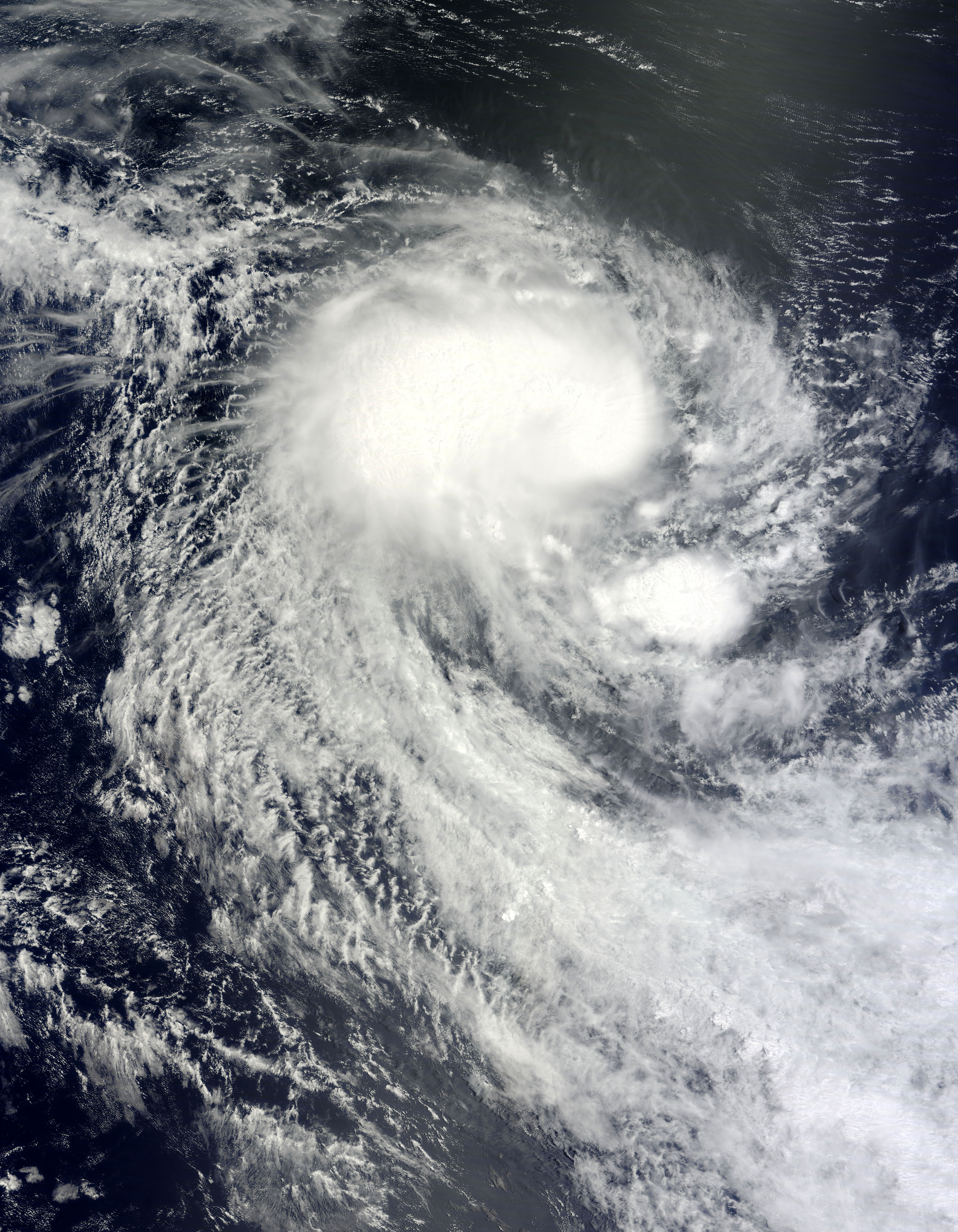
English: On November 30, 2010, the 2010 Atlantic hurricane season came to a close, but tropical cyclones are a global phenomenon, and it’s always cyclone season somewhere. On November 29, 2010, Tropical Cyclone Abele formed over the southern Indian Ocean. On December 1, 2010, the U.S. Navy’s Joint Typhoon Warning Center reported that Abele had maximum sustained winds of 40 knots (75 kilometers per hour) with gusts up to 50 knots (95 kilometers per hour). The storm was located some 675 nautical miles (1,250 kilometers) west-southwest of Cocos Island, Australia.
The Moderate Resolution Imaging Spectroradiometer (MODIS) on NASA’s Terra satellite captured this natural-color image of Abele on December 1, 2010. Abele spans hundreds of kilometers over the open ocean. The storm lacks a distinct eye, but sports the apostrophe shape characteristic of tropical cyclones. Over the past two centuries, tropical cyclones have killed nearly two million people, and forecasters worldwide continually strive to improve storm forecasts. In less developed parts of the globe, a dearth of data has historically hampered predictions. A new tool in forecasters’s arsenal, however, is the Pleiades supercomputer at NASA’s Ames Research Center. Relying on Pleiades’ computing muscle, researchers have been able to model storm formation by feeding the computer data about wind speed, temperature, and mositure. In the case of Cyclone Nargis, which struck in 2008, researchers were able to replicate the tropical cyclone’s formation five days in advance. The project offered hope for improving future predictions worldwide. |
| 日期 | |
| 来源 | http://earthobservatory.nasa.gov/NaturalHazards/view.php?id=47492 |
| 作者 | NASA image courtesy Jeff Schmaltz, MODIS Rapid Response Team at NASA GSFC. Caption by Michon Scott. |
许可协议
[编辑]
| 本文件完全由NASA创作,在美国属于公有领域。根据NASA的版权方针,NASA的材料除非另有声明否则不受版权保护。(参见Template:PD-USGov/zh、NASA版权方针页面或JPL图片使用方针。) | ||
 |
警告:
|
文件历史
点击某个日期/时间查看对应时刻的文件。
| 日期/时间 | 缩略图 | 大小 | 用户 | 备注 | |
|---|---|---|---|---|---|
| 当前 | 2010年12月1日 (三) 23:58 | | 5,600 × 7,200(5.62 MB) | Supportstorm(留言 | 贡献) | {{Information |Description={{en|1=On November 30, 2010, the 2010 Atlantic hurricane season came to a close, but tropical cyclones are a global phenomenon, and it’s always cyclone season somewhere. On November 29, 2010, Tropical Cyclone Abele formed over |
您不可以覆盖此文件。
文件用途
没有页面使用本文件。
全域文件用途
以下其他wiki使用此文件:
- de.wikipedia.org上的用途
- zh.wikipedia.org上的用途