File:Abraham Ortelius - Tvrcici imperii descriptio.jpg
跳至導覽
跳至搜尋

預覽大小:800 × 591 像素。 其他解析度:320 × 236 像素 | 640 × 473 像素 | 1,024 × 756 像素 | 1,280 × 946 像素 | 2,560 × 1,891 像素 | 3,085 × 2,279 像素。
原始檔案 (3,085 × 2,279 像素,檔案大小:2.64 MB,MIME 類型:image/jpeg)
說明
說明
添加單行說明來描述出檔案所代表的內容
摘要
[編輯]| 作者 | ||||||||||||||||||||||||
| 描述 |
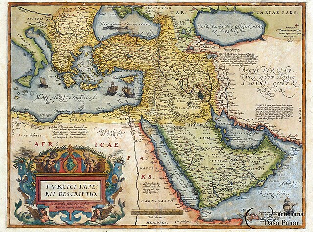
English: An engraved map and coloured by hand. It is part of A. Ortelius's atlas Teatrum Orbis Terarum, Antwerp, 1570, map no. 50
Română: Hartă gravată în aramă colorată de mână. Face parte din atlasul lui A. Ortelius, Theatrum Orbis Terrarum, Anvers, 1570, harta numărul 50 |
|||||||||||||||||||||||
| 日期 | 1570年 | |||||||||||||||||||||||
| 藏於 |
|
|||||||||||||||||||||||
| 來源/攝影者 | Muzeul Național al Hărților și Cărții Vechi, Romania | |||||||||||||||||||||||
| 其他版本 | https://www.muzeulhartilor.ro/wp-content/uploads/2017/11/a-ortelius-turcia.jpg | |||||||||||||||||||||||

.JPG)
授權條款
[編輯]
|
本作品在其來源國以及其他版權期限是作者逝世後100年或以下的國家與地區屬於公有領域。 | |
| 此作品無已知的著作權限制,亦不受所有相關和鄰接的權利限制。 | |
檔案歷史
點選日期/時間以檢視該時間的檔案版本。
| 日期/時間 | 縮圖 | 尺寸 | 用戶 | 備註 | |
|---|---|---|---|---|---|
| 目前 | 2015年11月30日 (一) 01:53 | | 3,085 × 2,279(2.64 MB) | Hairy Dude(對話 | 貢獻) | higher resolution, from [http://www.pahor.de/middle-east-ottoman-empire-turcici-imperii-descriptio.html Antiquariat Daša Pahor] |
| 2010年8月29日 (日) 16:49 |  | 640 × 528(131 KB) | Strainu(對話 | 貢獻) |
無法覆蓋此檔案。
檔案用途
下列5個頁面有用到此檔案:
全域檔案使用狀況
以下其他 wiki 使用了這個檔案:
- ar.wikipedia.org 的使用狀況
- azb.wikipedia.org 的使用狀況
- az.wikipedia.org 的使用狀況
- ca.wikipedia.org 的使用狀況
- cs.wikipedia.org 的使用狀況
- de.wikipedia.org 的使用狀況
- el.wikipedia.org 的使用狀況
- en.wikipedia.org 的使用狀況
- es.wikipedia.org 的使用狀況
- et.wikipedia.org 的使用狀況
- fa.wikipedia.org 的使用狀況
- fr.wikipedia.org 的使用狀況
- he.wikipedia.org 的使用狀況
- id.wikipedia.org 的使用狀況
- it.wikipedia.org 的使用狀況
- ja.wikipedia.org 的使用狀況
- ms.wikipedia.org 的使用狀況
- nl.wikipedia.org 的使用狀況
- pt.wikipedia.org 的使用狀況
- ru.wikipedia.org 的使用狀況
- si.wikipedia.org 的使用狀況
- sr.wikipedia.org 的使用狀況
- tr.wikipedia.org 的使用狀況
- www.wikidata.org 的使用狀況
- zh.wikipedia.org 的使用狀況
詮釋資料
分類:
- 16th-century maps of the Black Sea
- National museum of maps and rare books, Bucharest
- Theatrum Orbis Terrarum
- 1570 maps of the Ottoman Empire
- 16th-century maps of the Caucasus
- 16th-century maps of the Near East
- Old maps showing the whole Near East
- 16th-century maps of the Caspian Sea
- 16th-century maps of Arabia