File:Aegadian Islands map.png
跳转到导航
跳转到搜索
没有更高的分辨率。
Aegadian_Islands_map.png (690 × 528像素,文件大小:112 KB,MIME类型:image/png)
说明
说明
添加一行文字以描述该文件所表现的内容
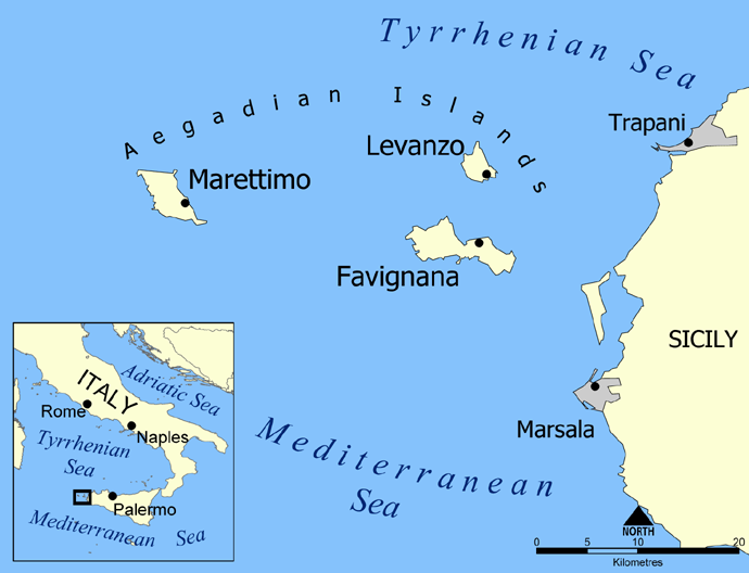
Map of the Aegadian Islands showing the islands of Favignana, Levanzo, and Marettimo, and the nearby port cities of Trapani and Marsala, Sicily.
Blank version available at Image:Aegadian Islands blank map.png.
Created by NormanEinstein, May 19, 2005.
| 我,本作品著作权人,释出本作品至公有领域。这适用于全世界。 在一些国家这可能不合法;如果是这样的话,那么: 我无条件地授予任何人以任何目的使用本作品的权利,除非这些条件是法律规定所必需的。 |
文件历史
点击某个日期/时间查看对应时刻的文件。
| 日期/时间 | 缩略图 | 大小 | 用户 | 备注 | |
|---|---|---|---|---|---|
| 当前 | 2016年2月26日 (五) 22:24 | | 690 × 528(112 KB) | Ras67(留言 | 贡献) | black frame removed, opt. |
| 2005年5月19日 (四) 13:58 |  | 700 × 538(150 KB) | NormanEinstein(留言 | 贡献) | Map of the Aegadian Islands showing the islands of Favignana, Levanzo, and Marettimo, and the nearby port cities of Trapani and Marsala, Sicily. Created by NormanEinstein, May 19, 2005. {{PD-self}} |
您不可以覆盖此文件。
文件用途
以下4个页面使用本文件:
全域文件用途
以下其他wiki使用此文件:
- ar.wikipedia.org上的用途
- be.wikipedia.org上的用途
- bg.wikipedia.org上的用途
- bs.wikipedia.org上的用途
- ca.wikipedia.org上的用途
- cs.wikipedia.org上的用途
- da.wikipedia.org上的用途
- de.wikipedia.org上的用途
- el.wikipedia.org上的用途
- en.wikipedia.org上的用途
- en.wiktionary.org上的用途
- eo.wikipedia.org上的用途
- fa.wikipedia.org上的用途
- fi.wikipedia.org上的用途
- fr.wikipedia.org上的用途
- fr.wiktionary.org上的用途
- fy.wikipedia.org上的用途
- gl.wikipedia.org上的用途
- he.wikipedia.org上的用途
- id.wikipedia.org上的用途
查看此文件的更多全域用途。