File:Aerial view of the Central Intelligence Agency headquarters, Langley, Virginia - Corrected and Cropped.jpg
跳至導覽
跳至搜尋
預覽大小:800 × 356 像素。 其他解析度:320 × 142 像素 | 640 × 284 像素 | 1,024 × 455 像素 | 1,280 × 569 像素 | 2,560 × 1,138 像素 | 5,523 × 2,455 像素。
原始檔案 (5,523 × 2,455 像素,檔案大小:7.57 MB,MIME 類型:image/jpeg)
說明
說明
添加單行說明來描述出檔案所代表的內容
摘要[編輯]
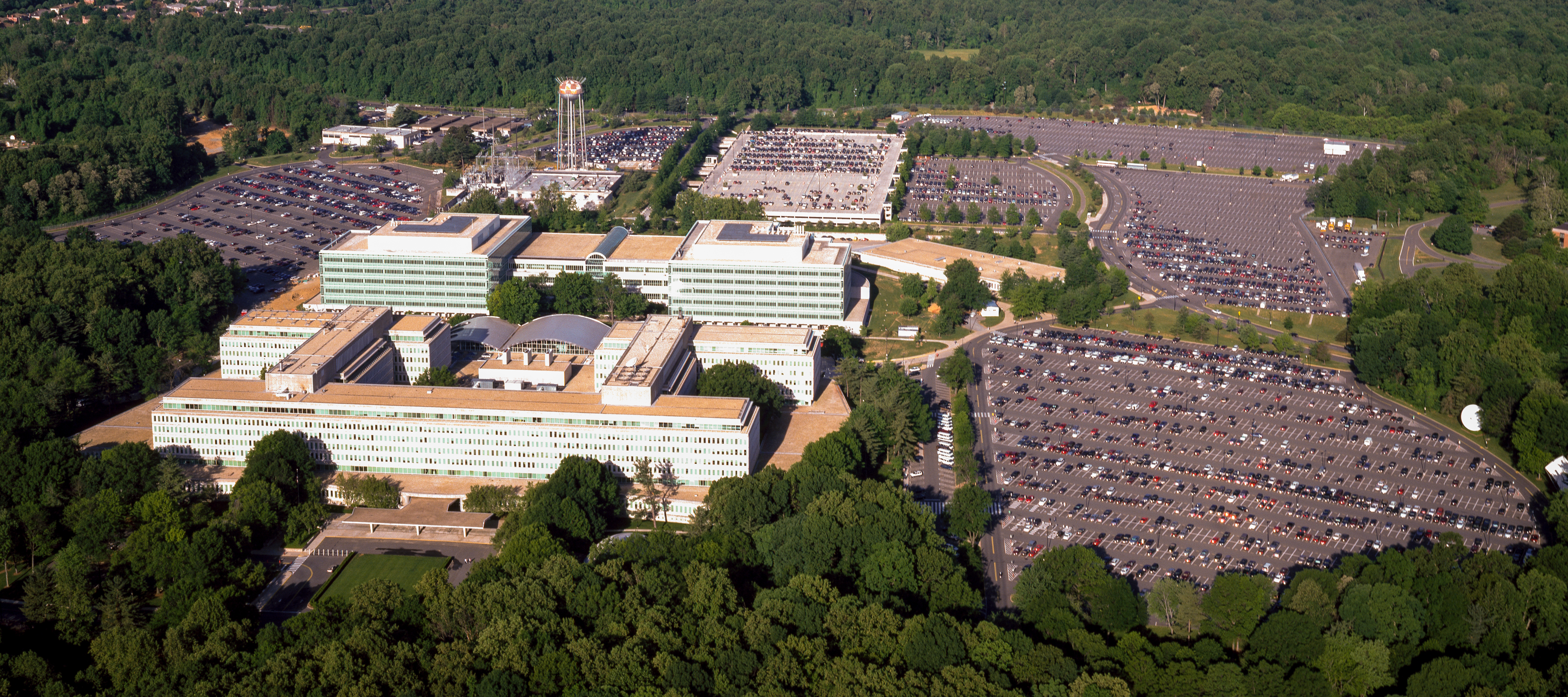
| Aerial view of the Central Intelligence Agency headquarters, Langley, Virginia
( |
|||||||||||||||||||||||||||
|---|---|---|---|---|---|---|---|---|---|---|---|---|---|---|---|---|---|---|---|---|---|---|---|---|---|---|---|
| 作者 |
|
||||||||||||||||||||||||||
| 標題 |
Aerial view of the Central Intelligence Agency headquarters, Langley, Virginia |
||||||||||||||||||||||||||
| 描繪地點 | Central Intelligence Agency headquarters | ||||||||||||||||||||||||||
| 日期 | 在1980年到2006年之間 | ||||||||||||||||||||||||||
| 表現方法 | 1 transparency : color | ||||||||||||||||||||||||||
| 尺寸 | 4 x 5 in. or smaller. | ||||||||||||||||||||||||||
| 藏於 | |||||||||||||||||||||||||||
| 目前所在位置 |
Prints and Photographs Division http://hdl.loc.gov/loc.pnp/pp.print |
||||||||||||||||||||||||||
| 備註 |
|
||||||||||||||||||||||||||
| 來源 |
|
||||||||||||||||||||||||||
| 授權許可 (重用此檔案) |
Rights Advisory: No known restrictions on publication. | ||||||||||||||||||||||||||
| 其他版本 |
|
||||||||||||||||||||||||||


| | 位於此地的本圖片與其他圖片: OpenStreetMap |
授權條款[編輯]
| This work is from the Carol M. Highsmith Archive collection at the Library of Congress. According to the library, there are no known copyright restrictions on the use of this work. Carol M. Highsmith has stipulated that her photographs are in the public domain. Photographs of sculpture or other works of art may be restricted by the copyright of the artist; see Commons:FOP US#Artworks and sculptures for more information. |
 |
檔案歷史
點選日期/時間以檢視該時間的檔案版本。
| 日期/時間 | 縮圖 | 尺寸 | 用戶 | 備註 | |
|---|---|---|---|---|---|
| 目前 | 2017年4月22日 (六) 16:17 | | 5,523 × 2,455(7.57 MB) | Falcorian(對話 | 貢獻) | User created page with UploadWizard |
無法覆蓋此檔案。
檔案用途
下列5個頁面有用到此檔案:
- Central Intelligence Agency
- File:Aerial view of the Central Intelligence Agency headquarters, Langley, Virginia - Corrected and Cropped.jpg
- File:Aerial view of the Central Intelligence Agency headquarters, Langley, Virginia 16449v.jpg
- Category:Awards and decorations of the Central Intelligence Agency
- Category:Central Intelligence Agency
全域檔案使用狀況
以下其他 wiki 使用了這個檔案:
- ar.wikipedia.org 的使用狀況
- arz.wikipedia.org 的使用狀況
- ast.wikipedia.org 的使用狀況
- azb.wikipedia.org 的使用狀況
- az.wikipedia.org 的使用狀況
- br.wikipedia.org 的使用狀況
- ca.wikipedia.org 的使用狀況
- ce.wikipedia.org 的使用狀況
- cs.wikipedia.org 的使用狀況
- cy.wikipedia.org 的使用狀況
- da.wikipedia.org 的使用狀況
- de.wikipedia.org 的使用狀況
- en.wikipedia.org 的使用狀況
- eo.wikipedia.org 的使用狀況
- eo.wikiquote.org 的使用狀況
- es.wikipedia.org 的使用狀況
- fi.wikipedia.org 的使用狀況
- fr.wikipedia.org 的使用狀況
- fr.wikinews.org 的使用狀況
- ga.wikipedia.org 的使用狀況
- ha.wikipedia.org 的使用狀況
- he.wikipedia.org 的使用狀況
- hu.wikipedia.org 的使用狀況
- id.wikipedia.org 的使用狀況
- it.wikipedia.org 的使用狀況
- ja.wikipedia.org 的使用狀況
- ko.wikipedia.org 的使用狀況
- ky.wikipedia.org 的使用狀況
- lt.wikipedia.org 的使用狀況
- lv.wikipedia.org 的使用狀況
- mn.wikipedia.org 的使用狀況
- ne.wikipedia.org 的使用狀況
- nn.wikipedia.org 的使用狀況
- no.wikipedia.org 的使用狀況
- ro.wikipedia.org 的使用狀況
- ru.wikipedia.org 的使用狀況
- ru.wikinews.org 的使用狀況
檢視此檔案的更多全域使用狀況。