File:Aerial view of the Changjin (Chosin) Reservoir penstocks in the Funchilin Pass, with a close-up of the damaged bridge.jpg
跳至導覽
跳至搜尋

預覽大小:777 × 599 像素。 其他解析度:311 × 240 像素 | 623 × 480 像素 | 996 × 768 像素 | 1,280 × 987 像素 | 2,560 × 1,974 像素 | 6,212 × 4,791 像素。
原始檔案 (6,212 × 4,791 像素,檔案大小:4.35 MB,MIME 類型:image/jpeg)
說明
說明
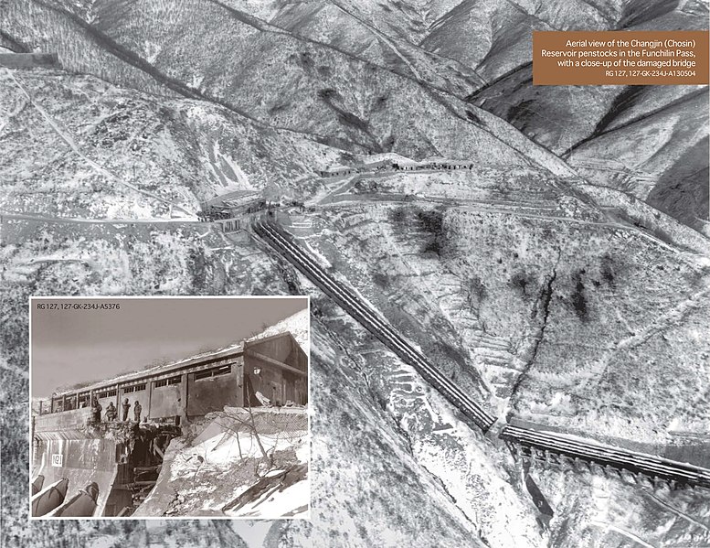
鳥瞰黃草嶺水電站
摘要
[編輯]_Reservoir_penstocks_in_the_Funchilin_Pass,_with_a_close-up_of_the_damaged_bridge.jpg&action=edit§ion=1)
| 攝影師 |
Sgt William R. Keating |
| 描述 |
中文:鳥瞰黃草嶺水力發電站。由美國陸戰隊第6偵察機中隊約翰·D·科頓中尉(John D. Cotton) 駕駛的輕型偵察機拍攝的鳥瞰圖,顯示了發電站、壓力水管,以及在陡峭的斜坡上切出的危險的道路。插圖是被炸斷的發電站水門橋。
English: Aerial view taken from one of VMO-6’s light observation aircraft, flown by 1st Lt. John D. Cotton, shows the power station at Funchilin Pass, the pipes or “penstocks” that carried off the water, and the precarious nature of the road occupying a thin shelf cut into the precipitous slope. The inset photo is a close-up of the blown bridge. |
| 日期 | 1950年 |
| 來源 | National Archive photo RG 127, 127-GK-234J-A130504 (main), 127-GK-234J-A5376(inset). Digital Copy from Barry W. Fowle, Office of History Headquarters, U.S. Army Corps of Engineers, 'Remembering the “Forgotten War”: U.S. Army Engineer Officers in Korea', p. 218 |
| 其他版本 |
  |
授權條款
[編輯]_Reservoir_penstocks_in_the_Funchilin_Pass,_with_a_close-up_of_the_damaged_bridge.jpg&action=edit§ion=2)
|
|
 |
檔案歷史
點選日期/時間以檢視該時間的檔案版本。
| 日期/時間 | 縮圖 | 尺寸 | 使用者 | 備註 | |
|---|---|---|---|---|---|
| 目前 | 2022年7月6日 (三) 05:53 | | 6,212 × 4,791(4.35 MB) | Happyseeu(留言 | 貢獻) | Uploaded a work by Sgt William R. Keating from Barry W. Fowle, Office of History Headquarters, U.S. Army Corps of Engineers, [https://www.publications.usace.army.mil/Portals/76/Publications/EngineerPamphlets/EP_870-1-66.pdf 'Remembering the “Forgotten War”: U.S. Army Engineer Officers in Korea'] with UploadWizard |
無法覆蓋此檔案。
檔案用途
下列2個頁面有用到此檔案:
_Reservoir_penstocks_in_the_Funchilin_Pass,_with_a_close-up_of_the_damaged_bridge.jpg)
全域檔案使用狀況
以下其他 wiki 使用了這個檔案:
- en.wikipedia.org 的使用狀況
- zh.wikipedia.org 的使用狀況
_Reservoir_penstocks_in_the_Funchilin_Pass,_with_a_close-up_of_the_damaged_bridge.jpg&oldid=785729643)