File:Africa de l'Oèst (fin sègle XVIII).png
Перейти к навигации
Перейти к поиску

Размер этого предпросмотра: 800 × 397 пкс. Другие разрешения: 320 × 159 пкс | 640 × 318 пкс | 1192 × 592 пкс.
Исходный файл (1192 × 592 пкс, размер файла: 172 КБ, MIME-тип: image/png)
Краткие подписи
Краткие подписи
Добавьте однострочное описание того, что собой представляет этот файл
Краткое описание
[править].png&action=edit§ion=1)
| Описание |
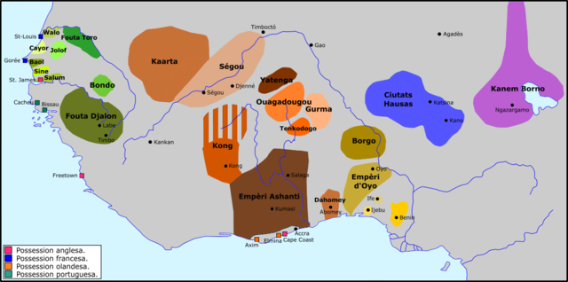
Occitan : Africa de l'Oèst a la fin dau sègle XVIII. |
| Дата | |
| Источник | Собственная работа |
| Автор | Nicolas Eynaud |
Лицензирование
[править].png&action=edit§ion=2)
Я, владелец авторских прав на это произведение, добровольно публикую его на условиях следующей лицензии:
Этот файл доступен по лицензии Creative Commons Attribution-Share Alike 4.0 International
- Вы можете свободно:
- делиться произведением – копировать, распространять и передавать данное произведение
- создавать производные – переделывать данное произведение
- При соблюдении следующих условий:
- атрибуция – Вы должны указать авторство, предоставить ссылку на лицензию и указать, внёс ли автор какие-либо изменения. Это можно сделать любым разумным способом, но не создавая впечатление, что лицензиат поддерживает вас или использование вами данного произведения.
- распространение на тех же условиях – Если вы изменяете, преобразуете или создаёте иное произведение на основе данного, то обязаны использовать лицензию исходного произведения или лицензию, совместимую с исходной.
История файла
Нажмите на дату/время, чтобы увидеть версию файла от того времени.
| Дата/время | Миниатюра | Размеры | Участник | Примечание | |
|---|---|---|---|---|---|
| текущий | 12:47, 24 декабря 2015 | | 1192 × 592 (172 КБ) | Nicolas Eynaud (обсуждение | вклад) | User created page with UploadWizard |
Вы не можете перезаписать этот файл.
Использование файла
Нет страниц, использующих этот файл.
Глобальное использование файла
Данный файл используется в следующих вики:
- Использование в ar.wikipedia.org
- Использование в de.wikipedia.org
- Использование в en.wikipedia.org
- Использование в es.wikipedia.org
- Использование в fi.wikipedia.org
- Использование в fr.wikipedia.org
- Использование в it.wikipedia.org
- Использование в nqo.wikipedia.org
- Использование в oc.wikipedia.org
- Использование в ru.wikipedia.org
- Использование в sv.wikipedia.org
- Использование в sw.wikipedia.org
- Использование в uk.wikipedia.org
- Использование в vi.wikipedia.org
Метаданные
.png&oldid=873545782)
Категории:
- Maps of the history of Mauritania
- Maps of the history of Senegal
- Maps of the history of the Gambia
- Maps of the history of Liberia
- Maps of the history of Guinea
- Maps of the history of Sierra Leone
- Maps of the history of Ghana
- Maps of the history of Togo
- Maps of the history of Benin
- Maps of the history of Nigeria
- Maps of the history of Chad
- Maps of the history of Niger
- Maps of the history of Burkina Faso
- Maps of the history of Ivory Coast
- Maps of 18th-century Africa
- Futa Tooro
- Kong Empire