File:Afsluitdijk Netherlands Satellite Photo by Sentinel-2 30 June 2018.jpg

元のファイル (4,305 × 3,847 ピクセル、ファイルサイズ: 12.89メガバイト、MIME タイプ: image/jpeg)
キャプション
キャプション
概要
[編集]| 解説 |
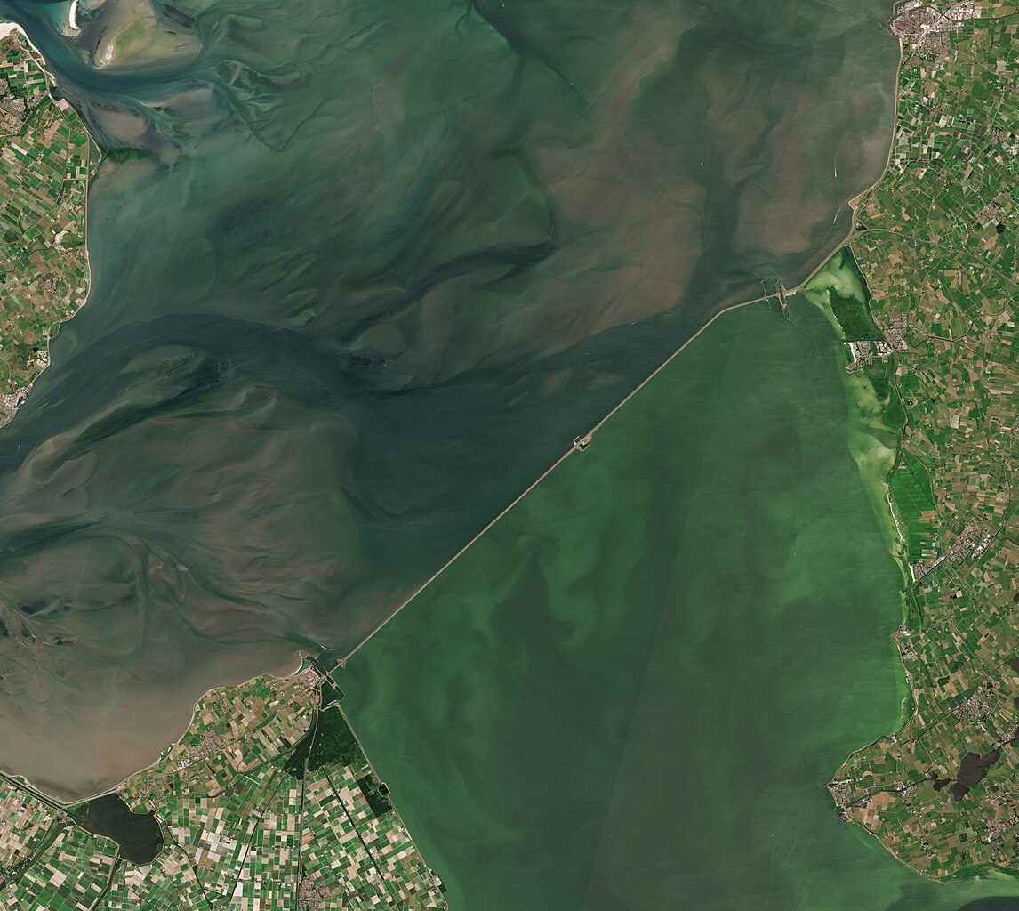
English: A satellite photo of the Afsluitdijk, The Netherlands, 30 June 2018. The Afsluitdijk changed the Zuiderzee into the IJsselmeer. To the north of the Afsluitdijk is the Wadden Sea, to the south is the IJsselmeer. Sensor: MSI on Sentinel-2A. Resolution: 10m. RGB Composites: True color, Band 4-3-2.
Nederlands: Een satellietfoto van de Afsluitdijk, Nederland, 30 juni 2018. De afsluitdijk veranderde de Zuiderzee in het IJsselmeer. Ten noorden van de Afsluitdijk is de Waddenzee, ten zuiden is het IJsselmeer. Sensor: MSI op Sentinel-2A. Resolutie: 10m. RGB-composieten: Ware Kleuren, Band 4-3-2. |
| 日付 | |
| 原典 | |
| 作者 | Copernicus Sentinel-2, ESA |
.jpg)
ライセンス
[編集]
- あなたは以下の条件に従う場合に限り、自由に
- 共有 – 本作品を複製、頒布、展示、実演できます。
- 再構成 – 二次的著作物を作成できます。
- あなたの従うべき条件は以下の通りです。
- 表示 – あなたは適切なクレジットを表示し、ライセンスへのリンクを提供し、変更があったらその旨を示さなければなりません。これらは合理的であればどのような方法で行っても構いませんが、許諾者があなたやあなたの利用行為を支持していると示唆するような方法は除きます。
- 継承 – もしあなたがこの作品をリミックスしたり、改変したり、加工した場合には、あなたはあなたの貢献部分を元の作品とこれと同一または互換性があるライセンスの下に頒布しなければなりません。

|
This image contains data from a satellite in the Copernicus Programme, such as Sentinel-1, Sentinel-2 or Sentinel-3. Attribution is required when using this image.
帰属: Contains modified Copernicus Sentinel data 2018
The use of Copernicus Sentinel Data is regulated under EU law (Commission Delegated Regulation (EU) No 1159/2013 and Regulation (EU) No 377/2014). Relevant excerpts:
Free access shall be given to GMES dedicated data [...] made available through GMES dissemination platforms [...].
Access to GMES dedicated data [...] shall be given for the purpose of the following use in so far as it is lawful:
GMES dedicated data [...] may be used worldwide without limitations in time.
GMES dedicated data and GMES service information are provided to users without any express or implied warranty, including as regards quality and suitability for any purpose. |
ファイルの履歴
過去の版のファイルを表示するには、その版の日時をクリックしてください。
| 日付と時刻 | サムネイル | 寸法 | 利用者 | コメント | |
|---|---|---|---|---|---|
| 現在の版 | 2023年7月4日 (火) 07:27 | | 4,305 × 3,847 (12.89メガバイト) | Artanisen (トーク | 投稿記録) | Uploaded a work by Copernicus Sentinel-2, ESA from Extracted from: North Holland with parts of Friesland and Flevoland by Sentinel-2 (Original 10m Res).jpg with UploadWizard |
このファイルは上書きできません。
ファイルの使用状況
以下の 2 ページがこのファイルを使用しています:
.png)
グローバルなファイル使用状況
以下に挙げる他のウィキがこの画像を使っています:
- af.wikipedia.org での使用状況
- arz.wikipedia.org での使用状況
- ast.wikipedia.org での使用状況
- ca.wikipedia.org での使用状況
- cs.wikipedia.org での使用状況
- de.wikipedia.org での使用状況
- en.wikipedia.org での使用状況
- eo.wikipedia.org での使用状況
- es.wikipedia.org での使用状況
- fr.wikipedia.org での使用状況
- fy.wikipedia.org での使用状況
- hu.wikipedia.org での使用状況
- ja.wikipedia.org での使用状況
- ko.wikipedia.org での使用状況
- nds-nl.wikipedia.org での使用状況
- nds.wikipedia.org での使用状況
- nl.wikipedia.org での使用状況
- pl.wikipedia.org での使用状況
- pt.wikipedia.org での使用状況
- www.wikidata.org での使用状況