File:Air Asia QZ8501 Flight Path and Satellite Imagery.jpg
跳至導覽
跳至搜尋

預覽大小:800 × 550 像素。 其他解析度:320 × 220 像素 | 640 × 440 像素 | 960 × 660 像素。
原始檔案 (960 × 660 像素,檔案大小:300 KB,MIME 類型:image/jpeg)
說明
說明
添加單行說明來描述出檔案所代表的內容
摘要
[編輯]
| 描述 |
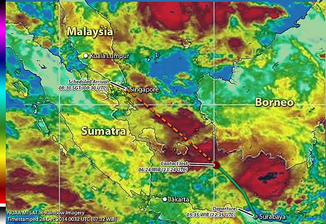
English: Flight path of Air Asia QZ8501 with Satellite Imagery on approx the time when the plane disappeared or lost contact. |
| 日期 | |
| 來源 |
自己的作品
The following materials were used for this upload:
|
| 作者 | Chitetskoy |
授權條款
[編輯]
我,本作品的著作權持有者,決定用以下授權條款發佈本作品:
此檔案採用共享創意 姓名標示-相同方式分享 4.0 國際授權條款。
- 您可以自由:
- 分享 – 複製、發佈和傳播本作品
- 重新修改 – 創作演繹作品
- 惟需遵照下列條件:
- 姓名標示 – 您必須指名出正確的製作者,和提供授權條款的連結,以及表示是否有對內容上做出變更。您可以用任何合理的方式來行動,但不得以任何方式表明授權條款是對您許可或是由您所使用。
- 相同方式分享 – 如果您利用本素材進行再混合、轉換或創作,您必須基於如同原先的相同或兼容的條款,來分布您的貢獻成品。
檔案歷史
點選日期/時間以檢視該時間的檔案版本。
| 日期/時間 | 縮圖 | 尺寸 | 用戶 | 備註 | |
|---|---|---|---|---|---|
| 目前 | 2015年1月5日 (一) 16:10 | | 960 × 660(300 KB) | Chitetskoy(對話 | 貢獻) | Added IR Color Scale for NOAA MTSAT-Rainbow Imagery as well as small label of the satimg timestamp. Sample can be found in this [url http://www.ssd.noaa.gov/mtsat/wpac/rb-l.jpg] which shows the MTSAT IR-Rainbow imagery focusing on Western Pacific area. |
| 2014年12月28日 (日) 13:00 |  | 960 × 660(295 KB) | Chitetskoy(對話 | 貢獻) | More high resolution file | |
| 2014年12月28日 (日) 12:57 |  | 960 × 660(187 KB) | Chitetskoy(對話 | 貢獻) | User created page with UploadWizard |
無法覆蓋此檔案。
檔案用途
下列2個頁面有用到此檔案:
全域檔案使用狀況
以下其他 wiki 使用了這個檔案:
- bn.wikipedia.org 的使用狀況
- cs.wikipedia.org 的使用狀況
- da.wikipedia.org 的使用狀況
- en.wikipedia.org 的使用狀況
- es.wikipedia.org 的使用狀況
- fo.wikipedia.org 的使用狀況
- hi.wikipedia.org 的使用狀況
- id.wikipedia.org 的使用狀況
- ja.wikipedia.org 的使用狀況
- ms.wikipedia.org 的使用狀況
- th.wikipedia.org 的使用狀況
- zh.wikipedia.org 的使用狀況