File:Airports and seaports map.png
跳至導覽
跳至搜尋
預覽大小:527 × 600 像素。 其他解析度:211 × 240 像素 | 422 × 480 像素 | 1,000 × 1,138 像素。
原始檔案 (1,000 × 1,138 像素,檔案大小:236 KB,MIME 類型:image/png)
說明
說明
添加單行說明來描述出檔案所代表的內容
摘要
[編輯]

|
本圖片是以PNG、GIF或JPEG格式上傳。然而,其中包含的資料或訊息,應該重新建立成可縮放向量圖形(SVG)檔案,以更有效率或更準確的方式儲存。如有可能,請上傳本圖片的SVG格式版本。在上傳之後,請修改維基各姊妹計畫中所有使用舊版圖片的條目(列在圖像連結章節中),替換為新版圖片,並在舊圖片的描述頁中加入{{Vector version available|新圖片名稱.svg}}模板,同時移除本模板。
|
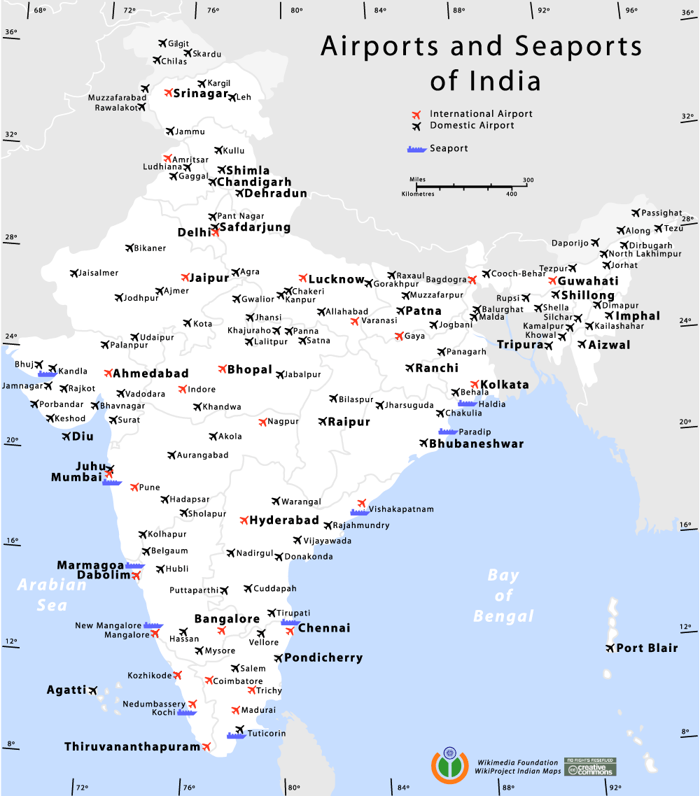
Airports and Seaports map of India
Author
[編輯]
我,本作品的著作權持有者,決定用以下授權條款發佈本作品:

|
已授權您依據自由軟體基金會發行的無固定段落、封面文字和封底文字GNU自由文件授權條款1.2版或任意後續版本,對本檔進行複製、傳播和/或修改。該協議的副本列在GNU自由文件授權條款中。 |
| 此檔案採用共享創意 姓名標示-相同方式分享 3.0 未在地化版本授權條款。 | ||
| ||
| 已新增授權條款標題至此檔案,作為GFDL授權更新的一部份。 |
您可以選擇您需要的授權條款。
de:Bild:Airports and seaports map.png
Am confused wid the number of international airports. its 13 here. i had read der r only 11.. which is the correct data?
| 註解 | 該圖片含有註解:在維基媒體共享資源上查看註解 |
檔案歷史
點選日期/時間以檢視該時間的檔案版本。
| 日期/時間 | 縮圖 | 尺寸 | 用戶 | 備註 | |
|---|---|---|---|---|---|
| 目前 | 2014年1月11日 (六) 20:57 | | 1,000 × 1,138(236 KB) | RaviC(對話 | 貢獻) | +Kargil |
| 2012年10月28日 (日) 20:41 |  | 1,000 × 1,138(263 KB) | RaviC(對話 | 貢獻) | Added all Intl airports not currently listed correctly. | |
| 2012年10月28日 (日) 18:26 |  | 1,000 × 1,138(161 KB) | RaviC(對話 | 貢獻) | Removed vandalism | |
| 2012年9月25日 (二) 05:09 |  | 1,000 × 1,138(256 KB) | Wantsallanger(對話 | 貢獻) | updated international status for srinagar etc as per source http://164.100.47.132/LssNew/psearch/QResult15.aspx?qref=78747 | |
| 2010年5月7日 (五) 18:34 |  | 1,000 × 1,138(180 KB) | RaviC(對話 | 貢獻) | finished adding airports in | |
| 2010年5月7日 (五) 17:29 |  | 1,000 × 1,138(179 KB) | RaviC(對話 | 貢獻) | Added more airports in the Kashmir region | |
| 2010年5月6日 (四) 19:33 |  | 1,000 × 1,138(178 KB) | RaviC(對話 | 貢獻) | Added airports in other areas of Kashmir. However, I cannot add all the names since I don't have the font. | |
| 2006年1月11日 (三) 15:05 |  | 1,000 × 1,138(108 KB) | Planemad(對話 | 貢獻) | Airports and Seaports map of India ==Author== w:user:planemad ==Revision== Original Category:Maps of India Category:Wikiproject Indian Maps |
無法覆蓋此檔案。
檔案用途
下列頁面有用到此檔案:
全域檔案使用狀況
以下其他 wiki 使用了這個檔案:
- bh.wikipedia.org 的使用狀況
- bn.wikipedia.org 的使用狀況
- bn.wikivoyage.org 的使用狀況
- ce.wikipedia.org 的使用狀況
- de.wikipedia.org 的使用狀況
- en.wikipedia.org 的使用狀況
- en.wikivoyage.org 的使用狀況
- fa.wikipedia.org 的使用狀況
- fa.wikivoyage.org 的使用狀況
- fr.wikipedia.org 的使用狀況
- gu.wikipedia.org 的使用狀況
- hi.wikipedia.org 的使用狀況
- hi.wikibooks.org 的使用狀況
- it.wikivoyage.org 的使用狀況
- ja.wikipedia.org 的使用狀況
- kn.wikipedia.org 的使用狀況
- ml.wikipedia.org 的使用狀況
- mr.wikipedia.org 的使用狀況
- new.wikipedia.org 的使用狀況
- nl.wikipedia.org 的使用狀況
- pa.wikipedia.org 的使用狀況
- pl.wikipedia.org 的使用狀況
- ru.wikipedia.org 的使用狀況
- sq.wikipedia.org 的使用狀況
- ta.wikipedia.org 的使用狀況
- te.wikipedia.org 的使用狀況
- zh.wikipedia.org 的使用狀況