File:Aj-map.png
Salta a la navegació
Salta a la cerca
No hi ha cap versió amb una resolució més gran.
Aj-map.png (325 × 349 píxels, mida del fitxer: 13 Ko, tipus MIME: image/png)
Llegendes
Llegendes
Afegeix una explicació d'una línia del que representa aquest fitxer
Resum
[modifica]
| Descripció |
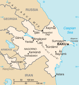
Türkçe: Azerbaycan'ın CIA tarafından oluşturulmuş haritası |
| Data | |
| Font | CIA World Factbook |
| Autor | United States Central Intelligence Agency |
Llicència
[modifica]
This image is in the public domain because it contains materials that originally came from the United States Central Intelligence Agency's World Factbook.
|
 |
Derivative works
[modifica]
Derivative works of this file: Mapa de Azerbaiyán.png
| Anotacions | Aquesta imatge té anotacions: Vegeu-les a Commons |
Historial del fitxer
Cliqueu una data/hora per veure el fitxer tal com era aleshores.
| Data/hora | Miniatura | Dimensions | Usuari/a | Comentari | |
|---|---|---|---|---|---|
| actual | 07:44, 19 feb 2022 | | 325 × 349 (13 Ko) | Lojwe (discussió | contribucions) | Cropped 1 % horizontally, 1 % vertically using CropTool with precise mode. |
| 12:44, 5 ago 2015 |  | 328 × 352 (14 Ko) | Ray Garraty (discussió | contribucions) | Reverted to version as of 22:26, 26 February 2005 | |
| 12:11, 5 ago 2015 |  | 328 × 352 (43 Ko) | Szczureq (discussió | contribucions) | Added border of Armenian-controlled Nagorno-Karabakh territory | |
| 22:26, 26 feb 2005 |  | 328 × 352 (14 Ko) | Alfio (discussió | contribucions) | Cia map of Azerbaijan |
No podeu sobreescriure aquest fitxer.
Ús del fitxer
Les 11 pàgines següents utilitzen aquest fitxer:
- Atlas of Azerbaijan
- Azərbaycan
- Maps of Azerbaijan
- User:Sanandros/ogre/secret intelligence/2014 August 21-31
- User:Sanandros/ogre/secret intelligence/2015 August 1-10
- File:Aj-map-ar.png
- File:Aj-map-lt.png
- File:Azerbaigian map.gif (fitxer redirigit)
- File:Azerbaigian map.png (fitxer redirigit)
- File:Azerbaijan-CIA WFB Map.png (fitxer redirigit)
- File:Mapa de Azerbaiyán.png
Ús global del fitxer
Utilització d'aquest fitxer en altres wikis:
- Utilització a ab.wikipedia.org
- Utilització a af.wikipedia.org
- Utilització a ast.wikipedia.org
- Utilització a av.wikipedia.org
- Utilització a azb.wikipedia.org
- Utilització a az.wikipedia.org
- Utilització a be-tarask.wikipedia.org
- Utilització a be.wikipedia.org
- Utilització a bg.wikipedia.org
- Utilització a bg.wiktionary.org
- Utilització a br.wikipedia.org
- Utilització a bs.wikipedia.org
- Utilització a ca.wikipedia.org
- Utilització a cs.wikipedia.org
- Utilització a cv.wikipedia.org
- Utilització a da.wikipedia.org
- Utilització a de.wikipedia.org
- Utilització a dsb.wikipedia.org
- Utilització a el.wikipedia.org
- Utilització a en.wikipedia.org
- Branobel
- SOCAR
- Dunsterforce
- Shah Deniz gas field
- Portal:Azerbaijan
- Portal:Azerbaijan/Azerbaijan-related topics
- Azeri–Chirag–Gunashli
- Extreme points of Azerbaijan
- Azerbaijan International Operating Company
- List of airports in Azerbaijan
- Darwin Bank
- Energy in Azerbaijan
- Karabakh oilfield
- Caspian International Petroleum Company
- Chirag oilfield
Vegeu més usos globals d'aquest fitxer.