File:Akna montes PIA00250.jpg
跳至導覽
跳至搜尋

預覽大小:360 × 599 像素。 其他解析度:144 × 240 像素 | 288 × 480 像素 | 462 × 768 像素 | 616 × 1,024 像素 | 1,694 × 2,817 像素。
原始檔案 (1,694 × 2,817 像素,檔案大小:1.09 MB,MIME 類型:image/jpeg)
說明
說明
添加單行說明來描述出檔案所代表的內容
摘要
[編輯]
| 描述 |
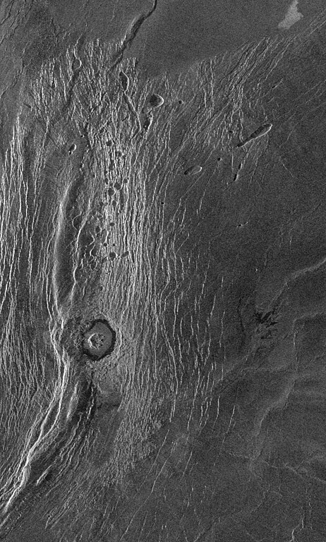
English: This Magellan full-resolution images show the northern part of the Akna Montes (mountains) of Venus. The Akna range is a north-south trending ridge belt that forms the western border of the elevated smooth plateau of Lakshmi Planum (plains). The Lakshmi plateau plains are formed by extensive volcanic eruptions and are bounded by mountain chains on all sides. The plains appear to be deformed near the mountains. This suggests that some of the mountain building activity occurred after the plains formed. An impact crater (Official International Astronomical Union name 'Wanda,' mapped first by the Soviet Venera 15/16 mission in 1984 at low resolution) with a diameter of 22 kilometers (14 miles) was formed by the impact of an asteroid in the Akna mountains. The crater has a rugged central peak and a smooth radar-dark floor, probably volcanic material. The crater does not appear to be much deformed by later crustal movement that uplifted the mountains and crumpled the plains. Material from the adjacent mountain ridge to the west, however, appears to have collapsed into the crater. Small pits seen to the north of the crater may be volcanic collapse pits a few kilometers across (1-2 miles). The ridge of the Akna mountains immediately to the west of the crater is 8 kilometers wide (5 miles). The area imaged is approximately 200 kilometers long and 125 kilometers wide (130 by 80 miles). This area is centered at 71.5 degrees north latitude, 324 degrees east longitude. The resolution of the Magellan radar system is 120 meters (400 feet). At this latitude the radar views the surface from an angle of 23 degrees off vertical, creating a perspective as though a viewer were looking at the scene from the right (east) at an angle of 23 degrees above the surface. |
| 來源 | photojournal.jpl.nasa.gov/catalog/PIA00250 |
| 作者 | NASA - Jet Propulsion Laboratory |
| 授權許可 (重用此檔案) |
Permission |
授權條款
[編輯]
| 本作品由NASA創作,屬於公有領域。根據NASA的版權政策:“NASA的創作除非另有聲明否則不受版權保護。”(參見:Template:PD-USGov/zh,NASA版權政策或JPL圖像使用政策) | ||
 |
警告:
|
檔案歷史
點選日期/時間以檢視該時間的檔案版本。
| 日期/時間 | 縮圖 | 尺寸 | 用戶 | 備註 | |
|---|---|---|---|---|---|
| 目前 | 2008年4月7日 (一) 06:04 | | 1,694 × 2,817(1.09 MB) | Bryan Derksen(對話 | 貢獻) | {{Information |Description={{en|This Magellan full-resolution images show the northern part of the Akna Montes (mountains) of Venus. The Akna range is a north-south trending ridge belt that forms the western border of the elevated smooth plateau of Lakshm |
無法覆蓋此檔案。
檔案用途
沒有使用此檔案的頁面。
全域檔案使用狀況
以下其他 wiki 使用了這個檔案:
- ar.wikipedia.org 的使用狀況
- bg.wikipedia.org 的使用狀況
- ca.wikipedia.org 的使用狀況
- ce.wikipedia.org 的使用狀況
- en.wikipedia.org 的使用狀況
- en.wikiversity.org 的使用狀況
- es.wikipedia.org 的使用狀況
- eu.wikipedia.org 的使用狀況
- fi.wikipedia.org 的使用狀況
- fr.wikipedia.org 的使用狀況
- gl.wikipedia.org 的使用狀況
- hi.wikipedia.org 的使用狀況
- it.wikipedia.org 的使用狀況
- nl.wikipedia.org 的使用狀況
- pl.wikipedia.org 的使用狀況
- sr.wikipedia.org 的使用狀況
- ta.wikipedia.org 的使用狀況
- www.wikidata.org 的使用狀況
- zh.wikipedia.org 的使用狀況