File:Albania Japan Locator.png
Pumunta sa nabigasyon
Pumunta sa paghahanap

Laki ng pasilip na ito: 800 x 351 na pixel. Ibang resolusyon: 320 x 140 na pixel | 640 x 281 na pixel | 1,425 x 625 na pixel.
Orihinal na file (1,425 × 625 na pixel, laki: 64 KB, uri ng MIME: image/png)
Captions
Captions
Add a one-line explanation of what this file represents

|
File:Albania Japan Locator.svg is a vector version of this file. It should be used in place of this PNG file when not inferior.
File:Albania Japan Locator.png → File:Albania Japan Locator.svg
For more information, see Help:SVG. |
 |
Buod
[baguhin]
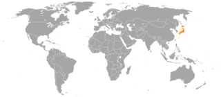
| Paglalarawan | Locator map showing Albania and Japan |
| Petsa | (UTC) |
| Pinanggalingan |
This file was derived from: BlankMap-World6, compact.svg: |
| May-akda |
|
| This is a retouched picture, which means that it has been digitally altered from its original version. Modifications: Highlight Albania and Japan. The original can be viewed here: BlankMap-World6, compact.svg:
|
Paglilisensiya
[baguhin]
Ako, na may karapatang-ari ng akdang ito, ang naglalathala nito alinsunod sa ilalim ng sumusunod na mga lisensya:
| Ako, ang may tangan ng karapatang-ari ng akdang ito, ay pinakakawalan ang akdang ito sa nasasakupan ng madla. Magagamit ito sa buong mundo. Maaaring hindi ito posibleng legal sa ilang mga bansa; kung ganito: Ibinibigay ko sa sinuman ang karapatang gamitin ang akdang ito para sa anumang layunin, na walang mga kundisyon, maliban na lang kung ang ganyang mga kundisyon ay kailangan ng batas. |
Tala ng orihinal na pagkarga
[baguhin]
This image is a derivative work of the following images:
- File:BlankMap-World6,_compact.svg licensed with PD-self
- 2012-08-25T19:32:02Z Kpengboy 940x415 (1518021 Bytes) Reverted to version as of 16:35, 13 February 2012 (there's a reason the code wasn't "optimised". re-add transparency if you think it's better)
- 2012-04-17T20:57:52Z Fred the Oyster 940x415 (837212 Bytes) Corrected my faux pas with the upper and lower margins
- 2012-04-17T20:13:20Z Fred the Oyster 940x490 (837200 Bytes) Optimise code, re-introduce transparency
- 2012-02-13T16:35:10Z Smurfy 940x415 (1518021 Bytes) South Sudan assigned proper country code ss
- 2011-07-21T10:51:07Z EmilJ 940x415 (1518021 Bytes) fix position of Marshall Islands, per [[File talk:BlankMap-World6.svg#Marshall Islands]]
- 2011-07-09T19:55:11Z Smurfy 940x415 (1517991 Bytes) Reverted to version as of 17:18, 9 July 2011
- 2011-07-09T19:54:56Z Smurfy 940x415 (1517991 Bytes) No changes, just attempting to make thumbnails update
- 2011-07-09T17:18:56Z Smurfy 940x415 (1517991 Bytes) Added South Sudan with code "qx" as per BlankMap-World6.svg
- 2010-05-24T23:02:45Z Saftorangen 940x415 (1515385 Bytes) To match the original map: "Grey move : B9B9B9 to E0E0E0 according to wikipedia convention." See the [[:commons:File_talk:BlankMap-World6.svg#Color_update_need|file talk of BlankMap-World6.svg]].
- 2009-10-12T06:40:51Z Fibonacci 940x415 (1515385 Bytes) Same fixes as for the full map.
- 2008-12-02T18:21:18Z Lokal Profil 940x415 (1518276 Bytes) Reverted to version as of 14:51, 13 June 2008, new image has non of the complexity (i.e. colouring abilities etc.) of the old
- 2008-12-02T17:29:39Z Harbin 1326x601 (176022 Bytes)
- 2008-12-02T17:26:08Z Harbin 1425x625 (189017 Bytes)
- 2008-06-13T14:51:25Z Lokal Profil 940x415 (1518276 Bytes) Syncing with [[:Image:BlankMap-World6.svg]] version (01:30, March 29, 2008). Sadly enough the validator does not seem to like rdf element of the metadata although it should work acording to http://www.w3schools.com/rdf/rdf_ma
- 2008-02-08T20:55:35Z CarolSpears 940x415 (1528750 Bytes) validated, maybe
- 2007-12-14T19:51:17Z Lokal Profil 940x415 (1529675 Bytes) Readded an ocean object but this one is square instead of the original elliptic one
- 2007-12-14T19:19:56Z Lokal Profil 940x415 (1529845 Bytes) {{Information |Description=Detailed SVG map with grouping enabled to connect all non-contiguous parts of a country's territory for easy colouring. Smaller countries can also be represented by larger circles to show their data
Uploaded with derivativeFX
Nakaraan ng file
Pindutin ang isang petsa/oras para makita ang file noong puntong yon.
| Petsa/Oras | Thumbnail | Sukat | Tagagamit | Komento | |
|---|---|---|---|---|---|
| ngayon | 18:53, 16 Enero 2017 | | 1,425 × 625 (64 KB) | Aquintero82 (usapan | ambag) | Updated map |
| 01:26, 12 Setyembre 2012 |  | 2,000 × 883 (205 KB) | Tobyc75 (usapan | ambag) | {{Information |Description ={{en|1=dummy}} |Source =dummy |Author =dummy |Date = |Permission = |other_versions = }} |
Hindi mo mao-overwrite ang file na ito.
Paggamit sa file
Ginagamit ng sumusunod na pahina ang file na ito:
Pandaigdigang paggamit sa file
Ginagamit ng mga sumusunod na wiki ang file na ito:
- Paggamit sa bn.wikipedia.org
- Paggamit sa en.wikipedia.org
- Paggamit sa es.wikipedia.org
- Paggamit sa fa.wikipedia.org
- Paggamit sa he.wikipedia.org
- Paggamit sa www.wikidata.org