File:Alberta's Cities.png
跳转到导航
跳转到搜索
本预览的尺寸:355 × 600像素。 其他分辨率:142 × 240像素 | 284 × 480像素 | 454 × 768像素 | 606 × 1,024像素 | 1,741 × 2,941像素。
原始文件 (1,741 × 2,941像素,文件大小:298 KB,MIME类型:image/png)
说明
说明
添加一行文字以描述该文件所表现的内容
摘要
[编辑]
| 描述 |
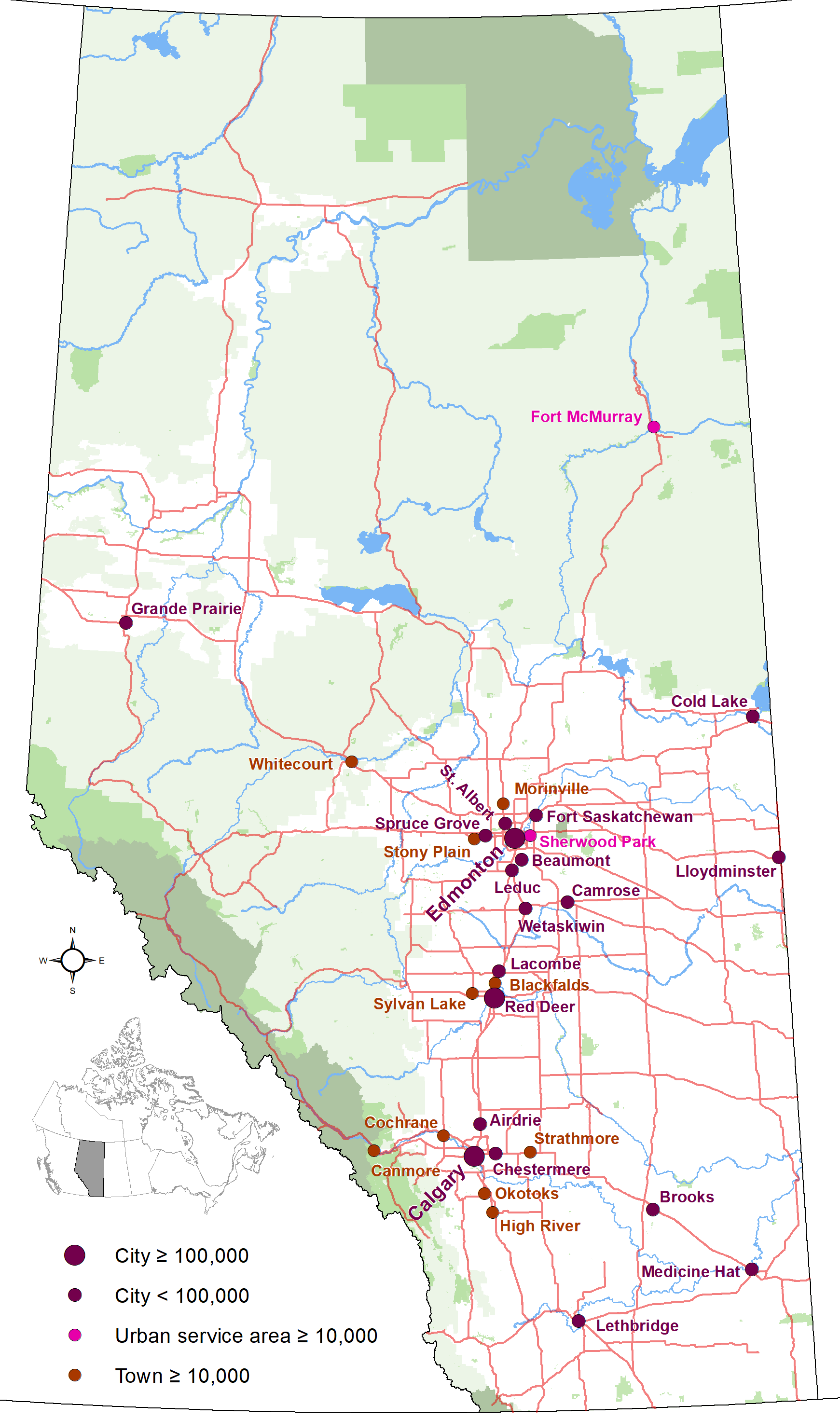
English: Map showing locations of Alberta 19 cities and city-equivalents (Fort McMurray and Sherwood Park urban service areas and towns with populations of 10,000 or greater) as of January 2019, with base reference features (major lakes and rivers, provincial 1-216 highway series, national parks, provincial protected areas and green and white areas). |
| 日期 | |
| 来源 | 自己的作品 |
| 作者 | Hwy43 |
许可协议
[编辑]
我,本作品著作权人,特此采用以下许可协议发表本作品:
本文件采用知识共享署名 3.0 未本地化版本许可协议授权。
- 您可以自由地:
- 共享 – 复制、发行并传播本作品
- 修改 – 改编作品
- 惟须遵守下列条件:
- 署名 – 您必须对作品进行署名,提供授权条款的链接,并说明是否对原始内容进行了更改。您可以用任何合理的方式来署名,但不得以任何方式表明许可人认可您或您的使用。
文件历史
点击某个日期/时间查看对应时刻的文件。
| 日期/时间 | 缩略图 | 大小 | 用户 | 备注 | |
|---|---|---|---|---|---|
| 当前 | 2020年10月25日 (日) 00:07 | | 1,741 × 2,941(298 KB) | Hwy43(留言 | 贡献) | Update to show Morinville is now eligible for city status with a population greater than 10,000. |
| 2019年1月2日 (三) 06:49 |  | 1,741 × 2,941(280 KB) | Hwy43(留言 | 贡献) | uploading again (accidentally uploaded an updated towns map instead) | |
| 2019年1月2日 (三) 06:46 |  | 1,741 × 2,941(262 KB) | Hwy43(留言 | 贡献) | Update to reflect Beaumont's change to city status and the Town of Blackfalds surpassing the city status minimum population threshold in its 2018 municipal census | |
| 2014年12月27日 (六) 09:08 |  | 2,321 × 3,921(392 KB) | Hwy43(留言 | 贡献) | updated to reflect Chestermere's change from town status to city status effective January 1, 2015 | |
| 2013年7月19日 (五) 06:07 |  | 1,741 × 2,941(277 KB) | Hwy43(留言 | 贡献) | User created page with UploadWizard |
您不可以覆盖此文件。
文件用途
以下页面使用本文件:
全域文件用途
以下其他wiki使用此文件:
- azb.wikipedia.org上的用途
- en.wikipedia.org上的用途
- fr.wikipedia.org上的用途
- is.wikipedia.org上的用途
- zh.wikipedia.org上的用途