File:Alberto 2006-06-12 1830Z.jpg

原始檔案 (6,100 × 7,700 像素,檔案大小:20.93 MB,MIME 類型:image/jpeg)
說明
說明
摘要[編輯]
| 描述 |
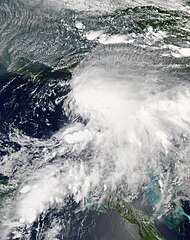
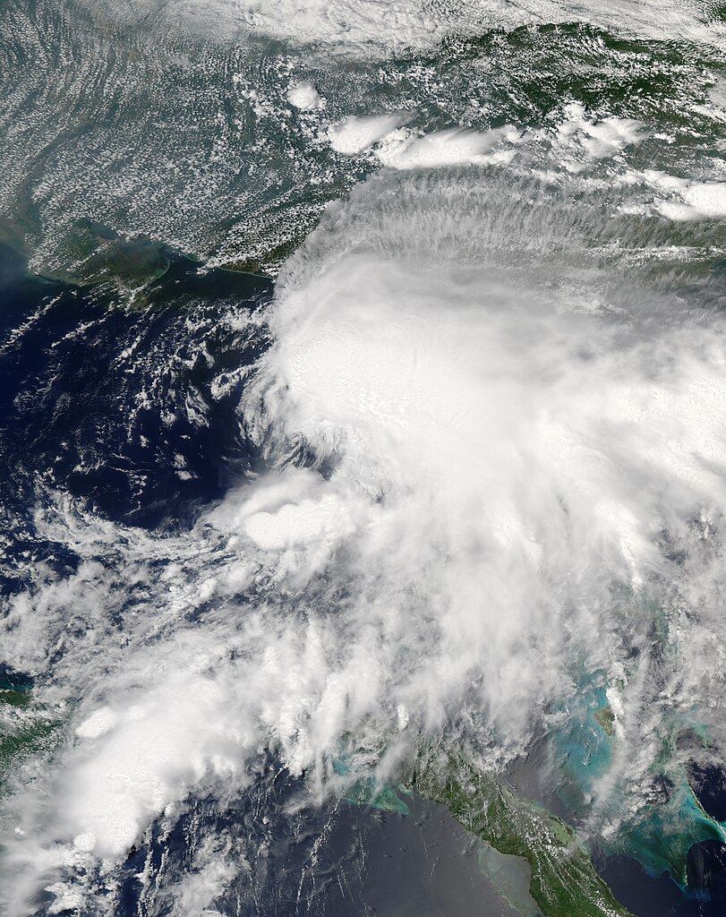
Tropical Storm Alberto formed as a tropical depression early in the morning on June 10, 2006, in the Yucatan Channel. Alberto gradually gathered strength as it took a slow track northward into the Gulf. By early morning on June 11, wind strength within the storm crossed the critical threshold of 39 knots (70 kilometers per hour; 45 miles per hour). Thus Alberto became the first named storm of the 2006 Atlantic hurricane season. Although Alberto briefly flirted with hurricane status as wind speeds came close to the necessary 64 knots (118 km/hr; 74 mph), the system remained a strong tropical storm as of the morning of June 13, and it was projected to weaken as it comes ashore in northern Florida. This photo-like image was acquired by the Moderate Resolution Imaging Spectroradiometer (MODIS) on the Aqua satellite on June 12, 2006, at 2:35 p.m. local time (18:35 UTC). The tropical storm did have hints of a spiral structure, but as in earlier satellite images, the bulk of the clouds and rainfall from the storm were east of the storm’s center. This large mass of clouds in the image appears over the Florida panhandle and mainland Florida, while the wind circulation center is located roughly 200 kilometers (120 miles) to the west of Tampa. Sustained winds in the storm system were estimated to be around 110 kilometers per hour (70 miles per hour) around the time the image was captured, according to the University of Hawaii’s Tropical Storm Information Center. However, the less-than-hurricane-strength winds did not mean that Alberto posed no significant hazards. Rainfall totals from the storm were predicted to be between 12 to 25 centimeters (5 to 10 inches), and the storm center was also expected to spawn tornadoes once Alberto crossed land. Drought-stricken Florida was looking for rain, but the heavy downpours predicted were also causing concerns about local flooding. |
|||||
| 來源 | http://earthobservatory.nasa.gov/NaturalHazards/view.php?id=16785 | |||||
| 作者 | NASA image created by Jesse Allen, Earth Observatory, using data obtained courtesy of the MODIS Rapid Response team. | |||||
| 授權許可 (重用此檔案) |
|

檔案歷史
點選日期/時間以檢視該時間的檔案版本。
| 日期/時間 | 縮圖 | 尺寸 | 使用者 | 備註 | |
|---|---|---|---|---|---|
| 目前 | 2019年9月6日 (五) 03:51 | | 6,100 × 7,700(20.93 MB) | Supportstorm(留言 | 貢獻) | Higher quality |
| 2018年12月6日 (四) 23:05 |  | 5,600 × 7,400(6.98 MB) | FleurDeOdile(留言 | 貢獻) | worldview | |
| 2015年12月27日 (日) 16:15 |  | 5,503 × 5,503(3.18 MB) | Nino Marakot(留言 | 貢獻) | Reverted to version as of 18:33, 13 June 2006 (UTC) | |
| 2013年11月13日 (三) 04:07 |  | 5,503 × 5,503(3.59 MB) | TheAustinMan(留言 | 貢獻) | Reverted (Earth's image exists not one but two other times...) | |
| 2013年6月9日 (日) 09:27 |  | 7,500 × 7,500(5.25 MB) | Earth100(留言 | 貢獻) | Best Image | |
| 2010年6月30日 (三) 19:21 |  | 5,503 × 5,503(3.59 MB) | Supportstorm(留言 | 貢獻) | Contrast Correction/ Sharpened | |
| 2006年6月13日 (二) 18:33 |  | 5,503 × 5,503(3.18 MB) | Good kitty(留言 | 貢獻) | ||
| 2006年6月13日 (二) 18:28 |  | 5,503 × 5,503(3.57 MB) | Good kitty(留言 | 貢獻) | ||
| 2006年6月12日 (一) 15:44 |  | 4,500 × 4,500(3.27 MB) | Good kitty(留言 | 貢獻) | Tropical Storm Alberto formed as an unnamed tropical depression early in the morning on June 10, 2006, in the Yucatan Channel. This narrow gap of ocean lies between the western end of Cuba and the Yucatan Peninsula at the mouth of the Gulf of Mexico. Albe |
無法覆蓋此檔案。
檔案用途
下列9個頁面有用到此檔案:
全域檔案使用狀況
以下其他 wiki 使用了這個檔案:
- de.wikipedia.org 的使用狀況
- en.wikipedia.org 的使用狀況
- User talk:Super-Magician
- 2006 Atlantic hurricane season
- User talk:CrazyC83
- User talk:AySz88
- User talk:BazookaJoe
- User:Merovingian/archive-13
- Timeline of the 2006 Atlantic hurricane season
- Tropical Storm Alberto (2006)
- User talk:NSLE/Archive 12
- User talk:WeatherVane
- User talk:Coredesat/Newsletters
- Wikipedia:WikiProject Tropical cyclones/Newsletter/Archive 2
- Wikipedia talk:WikiProject Tropical cyclones/Newsletter/Archive 2
- User talk:Miss Madeline/Archive Early 2006
- User talk:Titoxd/Archive16
- User talk:Icelandic Hurricane/July Archive
- User:Bob rulz/Hurricane Herald
- User talk:A7x/Newsletters
- User talk:Cyclone1/Archive1
- User talk:Hurricanehink/Archive 6
- User talk:Pobbie Rarr/Tropical cyclones WikiProject Newsletter archive
- User talk:Ajm81/Newsletters
- User talk:The Grid/Archive 1
- User talk:RaNdOm26/Archive 1
- User talk:Jamie C/Archive 1
- User talk:Typhoonchaser/Archive 1
- User talk:Sarsaparilla39/Archive 1
- Wikipedia:WikiProject Tropical cyclones/Newsletter/Archive
- Wikipedia:Main Page history/2011 June 17
- User talk:Hurricanehink/Archive 22
- es.wikipedia.org 的使用狀況
- eu.wikipedia.org 的使用狀況
- it.wikipedia.org 的使用狀況
- ja.wikipedia.org 的使用狀況
- ko.wikipedia.org 的使用狀況
- pt.wikipedia.org 的使用狀況
- simple.wikipedia.org 的使用狀況
- sv.wikipedia.org 的使用狀況
- www.wikidata.org 的使用狀況
- zh.wikipedia.org 的使用狀況
檢視此檔案的更多全域使用狀況。