File:Alexander archipelago.jpg
ნავიგაციაზე გადასვლა
ძიებაზე გადასვლა

ზომა წინასწარი გადახედვისას: 450 × 600 პიქსელი. სხვა გაფართოება: 180 × 240 პიქსელი | 360 × 480 პიქსელი | 576 × 768 პიქსელი | 1 050 × 1 400 პიქსელი.
თავდაპირველი ფაილი (1 050 × 1 400 პიქსელი, ფაილის ზომა: 529 კბ, MIME ტიპი: image/jpeg)
Captions
Captions
Add a one-line explanation of what this file represents
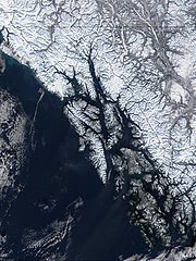
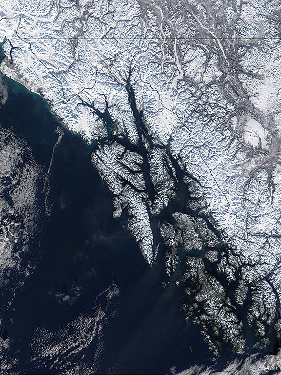
| აღწერა | West of British Columbia, Canada, and south of the Yukon Territory, the southeastern coastline of Alaska trails off into the islands of the Alexander Archipelago. The area is rugged and contains many long, U-shaped, glaciated valleys, many of which terminate at tidewater. The Alexander Archipelago is home to Glacier Bay National Park. The large bay that has two forks on its northern end is Glacier Bay itself. The eastern fork is Muir inlet, into which runs the Muir glacier, named for the famous Scottish-born naturalist John Muir. Glacier Bay opens up into the Icy Strait. The large, solid white area to the west is Brady Icefield, which terminates at the southern end in Brady's Glacier. |
| თარიღი | |
| წყარო | https://visibleearth.nasa.gov/images/57719/alexander-archipelago-southeastern-alaska |
| ავტორი | Jacques Descloitres, MODIS Land Rapid Response Team, NASA/GSFC |
| This file is in the public domain in the United States because it was solely created by NASA. NASA copyright policy states that "NASA material is not protected by copyright unless noted". (See Template:PD-USGov, NASA copyright policy page or JPL Image Use Policy.) | ||
 |
Warnings:
|
ფაილის ისტორია
დააწკაპუნეთ თარიღზე/დროზე, რათა იხილოთ ფაილი, როგორც ის მაშინ გამოიყურებოდა.
| თარიღი/დრო | მინიატიურა | განზომილებები | მომხმარებელი | კომენტარი | |
|---|---|---|---|---|---|
| მიმდინარე | 09:32, 1 ივნისი 2005 | | 1 050 × 1 400 (529 კბ) | Alib (განხილვა | წვლილი) | NASA MODIS satellite image of the Alexander archipelago, Alaska |
თქვენ არ შეგიძლიათ ამ ფაილზე გადაწერა.
ფაილის გამოყენება
მომდევნო გვერდები იყენებენ ამ ფაილს:
ფაილის გლობალური გამოყენება
ეს ფაილი გამოიყენება შემდეგ ვიკებში:
- გამოყენება ar.wikipedia.org-ში
- გამოყენება arz.wikipedia.org-ში
- გამოყენება ast.wikipedia.org-ში
- გამოყენება az.wikipedia.org-ში
- გამოყენება be.wikipedia.org-ში
- გამოყენება ca.wikipedia.org-ში
- გამოყენება ceb.wikipedia.org-ში
- გამოყენება cs.wikipedia.org-ში
- გამოყენება da.wikipedia.org-ში
- გამოყენება de.wikipedia.org-ში
- გამოყენება en.wikipedia.org-ში
- გამოყენება en.wikivoyage.org-ში
- გამოყენება eo.wikipedia.org-ში
- გამოყენება es.wikipedia.org-ში
- გამოყენება et.wikipedia.org-ში
- გამოყენება eu.wikipedia.org-ში
- გამოყენება fa.wikipedia.org-ში
- გამოყენება fi.wikipedia.org-ში
- გამოყენება fr.wikipedia.org-ში
იხილეთ, ამ ფაილის გლობალური გამოყენება.