File:Alice Springs ridge.jpeg
Aller à la navigation
Aller à la recherche
Pas de plus haute résolution disponible.
Alice_Springs_ridge.jpeg (768 × 511 pixels, taille du fichier : 436 kio, type MIME : image/jpeg)
Légendes
Légendes
Ajoutez en une ligne la description de ce que représente ce fichier
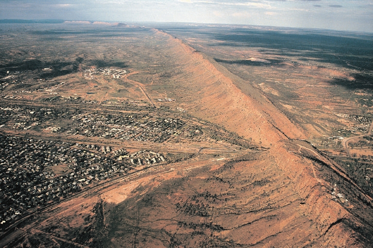
Aerial view of the southern half of Alice Springs, with Heavitree Gap in foreground
Description[modifier]
| Lieu de la prise de vue | | Voir cet endroit et d’autres images sur : OpenStreetMap |
|---|
Conditions d’utilisation[modifier]
Codrington, Stephen. Planet Geography 3rd Edition (2005) [1]
Personal photo by Stephen Codrington uploaded with permission for the benefit of geography on Wikimedia projects. This and other photos by Stephen Codrington are available to download and order at his personal website.
Ce fichier est disponible selon les termes de la licence Creative Commons Attribution 2.5 Générique.
Attribution: Stephen Codrington
- Vous êtes libre :
- de partager – de copier, distribuer et transmettre cette œuvre
- d’adapter – de modifier cette œuvre
- Sous les conditions suivantes :
- paternité – Vous devez donner les informations appropriées concernant l'auteur, fournir un lien vers la licence et indiquer si des modifications ont été faites. Vous pouvez faire cela par tout moyen raisonnable, mais en aucune façon suggérant que l’auteur vous soutient ou approuve l’utilisation que vous en faites.
Historique du fichier
Cliquer sur une date et heure pour voir le fichier tel qu'il était à ce moment-là.
| Date et heure | Vignette | Dimensions | Utilisateur | Commentaire | |
|---|---|---|---|---|---|
| actuel | 12 juillet 2005 à 02:57 | | 768 × 511 (436 kio) | Komencanto~commonswiki (d | contributions) | Caption: "''Figure 3.14 One of the larger settlements on the road that crosses Australia from north to south is Alice Springs. This view shows the transport links passing through a convenient gap in the ridge beside which the town has been built. The host |
Vous ne pouvez pas remplacer ce fichier.
Utilisations locales du fichier
Les 3 pages suivantes utilisent ce fichier :
Utilisations du fichier sur d’autres wikis
Les autres wikis suivants utilisent ce fichier :
- Utilisation sur af.wikipedia.org
- Utilisation sur arz.wikipedia.org
- Utilisation sur bg.wikipedia.org
- Utilisation sur de.wikipedia.org
- Utilisation sur de.wikivoyage.org
- Utilisation sur en.wikipedia.org
- Utilisation sur es.wikipedia.org
- Utilisation sur fr.wikipedia.org
- Utilisation sur fr.wikivoyage.org
- Utilisation sur hu.wikipedia.org
- Utilisation sur it.wikipedia.org
- Utilisation sur ja.wikipedia.org
- Utilisation sur ky.wikipedia.org
- Utilisation sur ml.wikipedia.org
- Utilisation sur nl.wikipedia.org
- Utilisation sur nn.wikipedia.org
- Utilisation sur ru.wikipedia.org
- Utilisation sur simple.wikipedia.org
- Utilisation sur tr.wikipedia.org
- Utilisation sur uk.wikipedia.org
- Utilisation sur vi.wikipedia.org
- Utilisation sur www.wikidata.org