File:American Hockey League 2011-12 map.svg
跳转到导航
跳转到搜索

此SVG文件的PNG预览的大小:601 × 600像素。 其他分辨率:241 × 240像素 | 481 × 480像素 | 770 × 768像素 | 1,026 × 1,024像素 | 2,053 × 2,048像素 | 1,742 × 1,738像素。
原始文件 (SVG文件,尺寸为1,742 × 1,738像素,文件大小:190 KB)
说明
说明
添加一行文字以描述该文件所表现的内容
| 描述 |
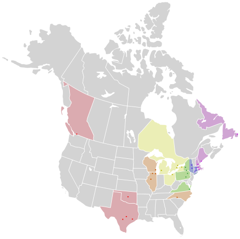
English: Map of Canada and the United States, showing the locations of American Hockey League teams as of the 2011–12 season. The cities, provinces, and states are color coded by conference and division:
Western Conference: West
Midwest
North
Eastern Conference: East
Northeast
Atlantic |
| 日期 | (UTC) |
| 来源 | |
| 作者 |
|
| 其他版本 |
此文件衍生的作品: |
我,本作品著作权人,特此采用以下许可协议发表本作品:
本文件采用知识共享署名-相同方式共享 2.5 通用许可协议授权。
- 您可以自由地:
- 共享 – 复制、发行并传播本作品
- 修改 – 改编作品
- 惟须遵守下列条件:
- 署名 – 您必须对作品进行署名,提供授权条款的链接,并说明是否对原始内容进行了更改。您可以用任何合理的方式来署名,但不得以任何方式表明许可人认可您或您的使用。
- 相同方式共享 – 如果您再混合、转换或者基于本作品进行创作,您必须以与原先许可协议相同或相兼容的许可协议分发您贡献的作品。
原始上传日志
[编辑]
This image is a derivative work of the following images:
- File:North_America_second_level_political_division_2.svg licensed with Cc-by-sa-2.5
- 2007-12-08T23:23:36Z Lokal Profil 1712x1992 (335351 Bytes) Code cleanup
- 2007-10-07T07:55:13Z AlexCovarrubias 1712x1992 (350437 Bytes) == Summary == {{Information |Description=Map of North America and its second-level political divisions. Canadian provinces, US and Mexican states. Canada, Mexico, United States. |Source=Canada and US map by Alan Rockefeller.
Uploaded with derivativeFX
文件历史
点击某个日期/时间查看对应时刻的文件。
| 日期/时间 | 缩略图 | 大小 | 用户 | 备注 | |
|---|---|---|---|---|---|
| 当前 | 2011年7月15日 (五) 19:21 | | 1,742 × 1,738(190 KB) | LtPowers(留言 | 贡献) | {{Information |Description={{en|Map of Canada and the United States, showing the locations of en:American Hockey League teams as of the 2011–12 season. The cities, provinces, and states are color coded by conference and division:}} '''Western |
您不可以覆盖此文件。