File:Americas Köppen Map.png
Aller à la navigation
Aller à la recherche

Taille de cet aperçu : 483 × 599 pixels. Autres résolutions : 193 × 240 pixels | 387 × 480 pixels | 619 × 768 pixels | 1 096 × 1 360 pixels.
Fichier d’origine (1 096 × 1 360 pixels, taille du fichier : 520 kio, type MIME : image/png)
Légendes
Légendes
Ajoutez en une ligne la description de ce que représente ce fichier
Description[modifier]
| Description |
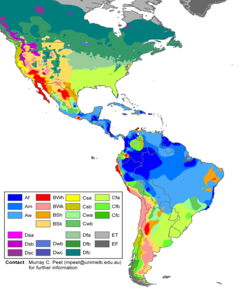
English: Edited Americas map of the Köppen-Geiger climate classification. The original was a world map JPG file which was converted to a smaller PNG file, without extra modifications, by Jeroen. The PNG file was further modified by WolfmanSF as follows: the map was cropped to reduce it to South America and most of North America; climate zone Dfa was changed to web color 99CC99, and climate zone Dfb was changed to web color 339933 (both shades of green); the color modifications to climate zones of temperate North America were intended to make the colors of tropical climate zones more distinctive, for use in articles on the Great American Interchange. The legend was rearranged, and climate zones Cwc, Dsd, Dwa, Dwd and Dfd were removed from the legend because they do not appear on this map. |
| Date | |
| Source | Hydrology and Earth System Sciences: "Updated world map of the Köppen-Geiger climate classification" (Supplement) |
| Auteur |
Peel, M. C., Finlayson, B. L., and McMahon, T. A. (University of Melbourne) Citation: Peel, M. C., Finlayson, B. L., and McMahon, T. A.: Updated world map of the Köppen-Geiger climate classification, Hydrol. Earth Syst. Sci., 11, 1633-1644, 2007. |
| Autres versions |
|

Conditions d’utilisation[modifier]
Ce fichier est disponible selon les termes de la licence Creative Commons Attribution – Partage dans les Mêmes Conditions 2.5 Générique
- Vous êtes libre :
- de partager – de copier, distribuer et transmettre cette œuvre
- d’adapter – de modifier cette œuvre
- Sous les conditions suivantes :
- paternité – Vous devez donner les informations appropriées concernant l'auteur, fournir un lien vers la licence et indiquer si des modifications ont été faites. Vous pouvez faire cela par tout moyen raisonnable, mais en aucune façon suggérant que l’auteur vous soutient ou approuve l’utilisation que vous en faites.
- partage à l’identique – Si vous modifiez, transformez, ou vous basez sur cette œuvre, vous devez distribuer votre contribution sous la même licence ou une licence compatible avec celle de l’original.
Historique du fichier
Cliquer sur une date et heure pour voir le fichier tel qu'il était à ce moment-là.
| Date et heure | Vignette | Dimensions | Utilisateur | Commentaire | |
|---|---|---|---|---|---|
| actuel | 20 février 2018 à 19:20 | | 1 096 × 1 360 (520 kio) | Maphobbyist (d | contributions) | The Costa Rican Central Valley has a dry winter oceanic climate (Köppen classification: Cwb). |
| 8 février 2018 à 00:19 |  | 1 096 × 1 360 (433 kio) | WolfmanSF (d | contributions) | Reverted to version as of 10:48, 27 December 2008 (UTC) - the northernmost areas aren't of much interest for the purposes of the Great American Interchange article which uses this image | |
| 7 février 2018 à 21:30 |  | 1 860 × 1 593 (526 kio) | Maphobbyist (d | contributions) | Included Alaska, Northern Canada and Greenland which were omitted. | |
| 27 décembre 2008 à 10:48 |  | 1 096 × 1 360 (433 kio) | WolfmanSF (d | contributions) | {{Information |Description= |Source= |Date= |Author= |Permission= |other_versions= }} | |
| 21 décembre 2008 à 21:46 |  | 1 096 × 1 360 (439 kio) | WolfmanSF (d | contributions) | rotate legend to make lettering horizontal; remove boxes for unused climate zones | |
| 5 mai 2008 à 05:21 |  | 1 096 × 1 360 (428 kio) | WolfmanSF (d | contributions) | {{Information |Description=Updated world map of the Köppen-Geiger climate classification. |Source=[http://www.hydrol-earth-syst-sci.net/11/1633/2007/hess-11-1633-2007.html Hydrology and Earth System Sciences: "Updated world map of the Köppen-Geiger clim |
Vous ne pouvez pas remplacer ce fichier.
Utilisations locales du fichier
Les 2 pages suivantes utilisent ce fichier :
- File:Americas Koppen Map.png (redirection de fichier)
- File:Americas Köppen Map original colors.png
Utilisations du fichier sur d’autres wikis
Les autres wikis suivants utilisent ce fichier :
- Utilisation sur az.wikipedia.org
- Utilisation sur bg.wikipedia.org
- Utilisation sur en.wikipedia.org
- Utilisation sur es.wikipedia.org
- Utilisation sur fr.wikipedia.org
- Utilisation sur he.wikipedia.org
- Utilisation sur nl.wikipedia.org