File:Amery Ice Shelf.jpg

Fichier d’origine (720 × 720 pixels, taille du fichier : 160 kio, type MIME : image/jpeg)
Légendes
Légendes
Description
[modifier]
| Description |
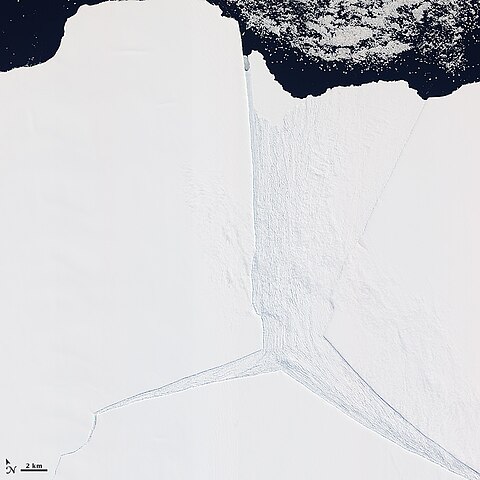
English: Several glaciers in East Antarctica, including the Lambert Glacier, share the same route to the ocean through the Amery Ice Shelf. Although comprising just a tiny portion of the Antarctic coastline, this ice shelf drains roughly 16 percent of the East Antarctic Ice Sheet. The Amery deposits ice into the ocean through the natural, cyclical process of iceberg calving—a process that can take decades to complete.
The Advanced Land Imager (ALI) on NASA’s Earth Observing-1 (EO-1) satellite captured this natural-color image on January 27, 2012. It shows a portion of the Amery Ice Shelf, where three giant cracks, or rifts, meet. The largest rift runs in the same direction as the ice flow, and widens toward the edge of the ice shelf (image center). Smaller rifts extend toward the east and west, and the tip of the western rift narrows and curves significantly (image lower left). These rifts lie along the western edge of a feature glaciologists have nicknamed Amery’s “loose tooth.” The tooth is a giant tabular iceberg that has been gradually loosening for more than a decade. The overall cycle of iceberg calving on the Amery Ice Shelf is slow, with the last major calving event occurring in the early 1960s. At that time, Amery released an ice island measuring roughly 140 by 70 kilometers. Although slow calving of icebergs has been the norm for the ice shelf, a rapid retreat is possible. Although much smaller than Antarctica’s largest ice shelves—the Ross and Filchner-Ronne—the Amery lies several degrees closer to the Equator. It also has some of the same traits as ice shelves that have retreated on the Antarctic Peninsula, such as extensive crevasses (cracks) and annual surface melt streams |
| Date | |
| Source | http://earthobservatory.nasa.gov/IOTD/view.php?id=77132 |
| Auteur | NASA Earth Observatory |
Conditions d’utilisation
[modifier]
| Ce fichier provient de la NASA. Sauf exception, les documents créés par la NASA ne sont pas soumis à copyright. Pour plus d'informations, voir la politique de copyright de la NASA. | ||
 |
Attention :
|
Historique du fichier
Cliquer sur une date et heure pour voir le fichier tel qu'il était à ce moment-là.
| Date et heure | Vignette | Dimensions | Utilisateur | Commentaire | |
|---|---|---|---|---|---|
| actuel | 24 février 2012 à 13:18 | | 720 × 720 (160 kio) | 4ing (d | contributions) |
Vous ne pouvez pas remplacer ce fichier.
Utilisations locales du fichier
Les 2 pages suivantes utilisent ce fichier :
- File:Amery ali 2012027.jpg (redirection de fichier)
- Category:Amery Ice Shelf
Utilisations du fichier sur d’autres wikis
Les autres wikis suivants utilisent ce fichier :
- Utilisation sur de.wikipedia.org
- Utilisation sur en.wikipedia.org
- Utilisation sur fr.wikipedia.org
- Utilisation sur he.wikipedia.org
- Utilisation sur it.wikipedia.org
- Utilisation sur ka.wikipedia.org
- Utilisation sur lt.wikipedia.org
- Utilisation sur mk.wikipedia.org
- Utilisation sur nn.wikipedia.org
- Utilisation sur pl.wikipedia.org
- Utilisation sur ru.wikipedia.org
- Utilisation sur sv.wikipedia.org
- Utilisation sur uk.wikipedia.org
- Utilisation sur www.wikidata.org
- Utilisation sur zh.wikipedia.org