File:Anatolia1200.png
Here nagîvasyonê
Here lêgerînê
Versyonekî jê mezintir tune.
Anatolia1200.png (642 × 430 pixel, mezinbûnê data: 86 KB, MIME-typ: image/png)
Captions
Captions
Add a one-line explanation of what this file represents

|
This historical map image could be re-created using vector graphics as an SVG file. This has several advantages; see Commons:Media for cleanup for more information. If an SVG form of this image is available, please upload it and afterwards replace this template with
{{vector version available|new image name}}.
It is recommended to name the SVG file “Anatolia1200.svg”—then the template Vector version available (or Vva) does not need the new image name parameter. |
Danasîn[biguhêre]
| Danasîn |
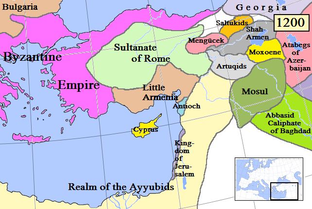
English: Map of Anatolia and some surrounding regions in AD 1200.
(Partially based on Euratlas map of Europe, 1200.) |
| Dîrok | |
| Çavkanî | Min çêkir |
| Xwedî | Gabagool |
| Guhartoyên din |
Derivative works of this file: Kingdom of Cilicia-Anatolia1200-Masry.jpg |
Lîsans[biguhêre]
I, the copyright holder of this work, hereby publish it under the following license:
This file is licensed under the Creative Commons Attribution 3.0 Unported license.
- Tu azad î:
- parve bike – ji bo kopîkirin, belavkirin û weşandina xebatê
- ji bo guhartin û adaptekirina naverokê – ji bo adaptekirina xebatê
- Di bin van mercan de:
- isnad – Divê tu isnadeke maqûl bikî, lînekek pêşkêş bikî ji bo lîsansê, û diyar bikî ku guhartin hatiye kirin an na. Tu dikarî vê yekê bi adilî bi cih bînî, lê ne bi awayê ku wekî lîsansor te an bikaranîna te pejirandibe.
Dîroka daneyê
Ji bo dîtina guhartoya wê demê bişkoka dîrokê bitikîne.
| Dîrok/Katjimêr | Wêneyê biçûk | Mezinahî | Bikarhêner | Şirove | |
|---|---|---|---|---|---|
| niha | 15:55, 19 nîsan 2009 | | 642 x 430 (86 KB) | Gabagool (gotûbêj | beşdarî) | Added more names to states. Cyprus now yellow to match other maps better. |
| 22:37, 17 nîsan 2009 |  | 642 x 430 (84 KB) | Gabagool (gotûbêj | beşdarî) | Extended Shah-Armen area per [http://en.wikipedia.org/wiki/Sassoun] ("The region was later ruled by the Mamikonian dynasty from around 772 until 1189/1190, when the Mamikonians moved to Cilicia after being dispossessed by Shah-Armen.") New Armenia -> Litt | |
| 23:54, 2 nîsan 2009 |  | 642 x 430 (84 KB) | Gabagool (gotûbêj | beşdarî) | {{Information |Description={{en|1=Map of Anatolia and some surrounding regions in AD 1200. (Partially based on Euratlas map of Europe, 1200.)}} |Source=Own work by uploader |Author=Gabagool |Date=2009-04-03 |Permission= |other_versions= |
Tu nikarî cardin li ser vê dosyeyê binivîsînî.
Bikaranîna pelê
Ev 5 rûpel li jêr vê dosyeyê bi kar tînin:
Bikaranîna gerdûnî ya pelê
Ev wîkiyên di rêzê de vê pelê bi kar tînin:
- Bikaranîna di ar.wikipedia.org de
- Bikaranîna di ast.wikipedia.org de
- Bikaranîna di azb.wikipedia.org de
- Bikaranîna di az.wikipedia.org de
- Bikaranîna di be.wikipedia.org de
- Bikaranîna di de.wikipedia.org de
- Bikaranîna di el.wikipedia.org de
- Bikaranîna di en.wikipedia.org de
- Bikaranîna di eo.wikipedia.org de
- Bikaranîna di es.wikipedia.org de
- Bikaranîna di et.wikipedia.org de
- Bikaranîna di fa.wikipedia.org de
- Bikaranîna di fr.wikipedia.org de
- Bikaranîna di gl.wikipedia.org de
- Bikaranîna di hy.wikipedia.org de
- Bikaranîna di hyw.wikipedia.org de
- Bikaranîna di it.wikipedia.org de
- Bikaranîna di ja.wikipedia.org de
- Bikaranîna di ka.wikipedia.org de
- Bikaranîna di kk.wikipedia.org de
- Bikaranîna di ko.wikipedia.org de
- Bikaranîna di lt.wikipedia.org de
- Bikaranîna di ml.wikipedia.org de
- Bikaranîna di nl.wikipedia.org de
- Bikaranîna di no.wikipedia.org de
- Bikaranîna di pnb.wikipedia.org de
- Bikaranîna di pt.wikipedia.org de
- Bikaranîna di ro.wikipedia.org de
- Bikaranîna di ru.wikipedia.org de
Zêdetir bikaranîna global a vê pelê bibîne.