File:Anatolia1300.png
跳至導覽
跳至搜尋
無更高解析度可提供。
Anatolia1300.png (535 × 330 像素,檔案大小:81 KB,MIME 類型:image/png)
說明
說明
添加單行說明來描述出檔案所代表的內容
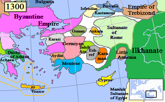
Map of the Anatolia region in AD 1300
摘要
[編輯]| 描述 |
English: Map of the Anatolia region in AD 1300.
(Partially based on Euratlas map of Europe, 1300.) |
| 日期 | |
| 來源 | 自己的作品 |
| 作者 | Gabagool |
| 其他版本 |
.png)
授權條款
[編輯]
我,本作品的著作權持有者,決定用以下授權條款發佈本作品:
此檔案採用創用CC 姓名標示 3.0 未在地化版本授權條款。
- 您可以自由:
- 分享 – 複製、發佈和傳播本作品
- 重新修改 – 創作演繹作品
- 惟需遵照下列條件:
- 姓名標示 – 您必須指名出正確的製作者,和提供授權條款的連結,以及表示是否有對內容上做出變更。您可以用任何合理的方式來行動,但不得以任何方式表明授權條款是對您許可或是由您所使用。
檔案歷史
點選日期/時間以檢視該時間的檔案版本。
| 日期/時間 | 縮圖 | 尺寸 | 用戶 | 備註 | |
|---|---|---|---|---|---|
| 目前 | 2017年1月20日 (五) 16:46 | | 535 × 330(81 KB) | Cplakidas(對話 | 貢獻) | fixing Dodecanese: Menteshe never controlled the offshore islands; they remained Byzantine until the Hospitallers or Genoese of Chios took them. |
| 2009年4月17日 (五) 22:26 |  | 535 × 330(64 KB) | Gabagool(對話 | 貢獻) | Byzantine color lighter. New Armenia -> Little Armenia | |
| 2009年4月2日 (四) 19:12 |  | 535 × 330(64 KB) | Gabagool(對話 | 貢獻) | added mamluks | |
| 2009年3月31日 (二) 16:36 |  | 535 × 330(63 KB) | Gabagool(對話 | 貢獻) | {{Information |Description={{en|1=Map of the Anatolia region in AD 1300. (Partially based on Euratlas map of Europe, 1300.)}} |Source=Own work by uploader |Author=Gabagool |Date=2009-03-31 |Permission= |other_versions= }} <!--{{ImageUp |
無法覆蓋此檔案。
檔案用途
全域檔案使用狀況
以下其他 wiki 使用了這個檔案:
- als.wikipedia.org 的使用狀況
- arz.wikipedia.org 的使用狀況
- azb.wikipedia.org 的使用狀況
- az.wikipedia.org 的使用狀況
- ba.wikipedia.org 的使用狀況
- bg.wikipedia.org 的使用狀況
- bn.wikipedia.org 的使用狀況
- ca.wikipedia.org 的使用狀況
- cs.wikipedia.org 的使用狀況
- de.wikipedia.org 的使用狀況
- el.wikipedia.org 的使用狀況
- en.wikipedia.org 的使用狀況
檢視此檔案的更多全域使用狀況。