File:Ancient Levant routes.png
跳转到导航
跳转到搜索

本预览的尺寸:800 × 541像素。 其他分辨率:320 × 217像素 | 640 × 433像素 | 919 × 622像素。
原始文件 (919 × 622像素,文件大小:290 KB,MIME类型:image/png)
说明
说明
添加一行文字以描述该文件所表现的内容
摘要
[编辑]
| 描述 |
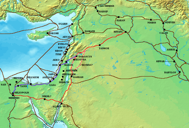
The en:Via Maris (purple), King's Highway (in red), and other ancient en:Levantine en:trade routes, c. en:1300 BCE en:Category:Historical maps by User:Briangotts |
| 日期 | 2006年5月24日 (原始上传日期) |
| 来源 | Transferred from en.wikipedia to Commons. |
| 作者 | 英语维基百科的Briangotts |
许可协议
[编辑]
Briangotts at the English Wikipedia,本作品著作权人,特此采用以下许可协议发表本作品:

|
已授权您依据自由软件基金会发行的无固定段落及封面封底文字(Invariant Sections, Front-Cover Texts, and Back-Cover Texts)的GNU自由文件许可协议1.2版或任意后续版本的条款,复制、传播和/或修改本文件。该协议的副本请见“GNU Free Documentation License”。 |
| 本文件采用知识共享署名-相同方式共享 3.0 未本地化版本许可协议授权。 | ||
| 署名: Briangotts at the English Wikipedia | ||
| ||
| 本许可协议标签作为GFDL许可协议更新的组成部分被添加至本文件。 |
原始上传日志
[编辑]
The original description page was here. All following user names refer to en.wikipedia.
- 2006-05-24 18:48 Briangotts 919×622×8 (326236 bytes) The [[Via Maris]] (purple), [[King's Highway (ancient)|King's Highway]] (in red), and other ancient [[Levant]]ine [[trade route]]s, c. 1300 BCE]] [[Category:Historical maps by User:Briangotts]]
ATTENTION, il semble que la carte soit fausse, car la vraie Bosra est bien plus a l'Est (voir ma discussion)
文件历史
点击某个日期/时间查看对应时刻的文件。
| 日期/时间 | 缩略图 | 大小 | 用户 | 备注 | |
|---|---|---|---|---|---|
| 当前 | 2010年10月4日 (一) 09:57 | | 919 × 622(290 KB) | Arpenteur31(留言 | 贡献) | correction of the roman road (Via Nova Traiana), according to geographic coordinates of BOSRA |
| 2007年7月20日 (五) 15:15 |  | 919 × 622(319 KB) | Briangotts(留言 | 贡献) | {{Information |Description The Via Maris (purple), King's Highway (in red), and other ancient Levantine trade routes, c. 1300 BCE. |Source=self-made |Date= |Author= Briangotts }} [[Category: | |
| 2007年6月18日 (一) 18:09 |  | 919 × 622(319 KB) | Matthiasb(留言 | 贡献) | {{Information |Description=The en:Via Maris (purple), King's Highway (in red), and other ancient en:Levantine en:trade routes, c. en:1300 BCE en:Category:Historical maps by User:Briangotts |Source |
您不可以覆盖此文件。
文件用途
以下2个页面使用本文件:
全域文件用途
以下其他wiki使用此文件:
- ast.wikipedia.org上的用途
- be.wikipedia.org上的用途
- bg.wikipedia.org上的用途
- bn.wikipedia.org上的用途
- br.wikipedia.org上的用途
- ca.wikipedia.org上的用途
- ceb.wikipedia.org上的用途
- cs.wikipedia.org上的用途
- cv.wikipedia.org上的用途
- da.wikipedia.org上的用途
- de.wikipedia.org上的用途
- de.wikiversity.org上的用途
- de.wikivoyage.org上的用途
- diq.wikipedia.org上的用途
- el.wikipedia.org上的用途
- en.wikipedia.org上的用途
- es.wikipedia.org上的用途
- et.wikipedia.org上的用途
- eu.wikipedia.org上的用途
- fr.wikipedia.org上的用途
- gl.wikipedia.org上的用途
- ha.wikipedia.org上的用途
- he.wikipedia.org上的用途
查看此文件的更多全域用途。