File:Ancient colonies.PNG
跳转到导航
跳转到搜索

本预览的尺寸:800 × 400像素。 其他分辨率:320 × 160像素 | 640 × 320像素 | 1,024 × 512像素 | 1,280 × 639像素 | 2,500 × 1,249像素。
原始文件 (2,500 × 1,249像素,文件大小:761 KB,MIME类型:image/png)
说明
说明
添加一行文字以描述该文件所表现的内容
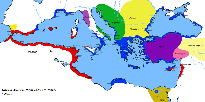
Map of the colonies of Ancient Greece and Phoenicia — circa 550 BCE. Phoenicia and Phoenician colonial areas in red, Greece and Greek colonial areas in blue; other areas as marked.
摘要
[编辑]
| 描述 |
English: Map of the colonies of Ancient Greece and Phoenicia — circa 550 BCE.
|
| 日期 | 2008年3月1日 (原始上传日期) |
| 来源 | 自己的作品 (Original text: self-made) |
| 作者 | Javierfv1212 (talk) |
| 其他版本 | العربيَّة |
许可协议
[编辑]
| 本作品已被作者英语维基百科的Javierfv1212释出到公有领域。这适用于全世界。 在一些国家这可能不合法;如果是这样的话,那么: Javierfv1212无条件地授予任何人以任何目的使用本作品的权利,除非这些条件是法律规定所必需的。 |
原始上传日志
[编辑]
Transferred from en.wikipedia to Commons by Javierfv1212.
The original description page was here. All following user names refer to en.wikipedia.
- 2008-03-08 15:09 Megistias 2500×1249× (768071 bytes) == Summary == {{Information |Description=Greek and Phoenecian colonies about 550 bc |Source=self-made |Date= |Location= |Author=[[User:Javierfv1212|Javierfv1212]] ([[User talk:Javierfv1212|talk]]),Modified by [[User:Megistias]] in the illyrian,thracian,gr
- 2008-03-01 03:09 Javierfv1212 2500×1249× (819010 bytes) {{Information |Description=Greek and Phoenecian colonies about 550 bc |Source=self-made |Date= |Location= |Author=~~~ |other_versions= }}
文件历史
点击某个日期/时间查看对应时刻的文件。
| 日期/时间 | 缩略图 | 大小 | 用户 | 备注 | |
|---|---|---|---|---|---|
| 当前 | 2014年2月23日 (日) 20:33 | | 2,500 × 1,249(761 KB) | Spiridon Ion Cepleanu(留言 | 贡献) | Little changes since H.E. Stier (dir.), Westermann Grosser Atlas zur Weltgeschichte, 1985, ISBN 3-14-100919-8 |
| 2012年6月11日 (一) 03:45 |  | 2,500 × 1,249(750 KB) | OgreBot(留言 | 贡献) | (BOT): Reverting to most recent version before archival | |
| 2012年6月11日 (一) 03:41 |  | 2,500 × 1,249(800 KB) | OgreBot(留言 | 贡献) | (BOT): Uploading old version of file from en.wikipedia; originally uploaded on 2008-03-01 03:09:18 by Javierfv1212 | |
| 2012年1月27日 (五) 19:47 |  | 2,500 × 1,249(750 KB) | 배우는사람(留言 | 贡献) | {{Information |Description={{en|Greek and Phoenician colonies about 550 bc}} |Source=Transferred from [http://en.wikipedia.org en.wikipedia]; transfer was stated to be made by User:Javierfv1212.<br/> (Original text : ''self-made'') |Date={{Date|2008|0 |
您不可以覆盖此文件。
文件用途
以下页面使用本文件:
全域文件用途
以下其他wiki使用此文件:
- ar.wikipedia.org上的用途
- bg.wikipedia.org上的用途
- el.wikipedia.org上的用途
- en.wikipedia.org上的用途
- es.wikipedia.org上的用途
- es.wikibooks.org上的用途
- fa.wikipedia.org上的用途
- fi.wikipedia.org上的用途
- fr.wikipedia.org上的用途
- hr.wikipedia.org上的用途
- it.wikiversity.org上的用途
- ko.wikipedia.org上的用途
- mzn.wikipedia.org上的用途
- no.wikipedia.org上的用途
- pt.wikipedia.org上的用途
- ro.wikipedia.org上的用途
- ru.wikipedia.org上的用途
- sk.wikipedia.org上的用途
- sl.wikipedia.org上的用途
- sr.wikipedia.org上的用途
- uk.wikipedia.org上的用途
- www.wikidata.org上的用途
- zh.wikipedia.org上的用途
元数据
分类:
- Former colonies
- Maps of the Greek colonies
- Maps of Phoenicia
- 550s BC
- Maps of the European Antiquity
- Maps of the ancient Near East
- Maps of the history of North Africa
- Maps of the Mediterranean Basin
- Maps of former countries
- Maps of international relations
- Political history maps
- Maps of Phoenician colonies
- Regions of ancient Greece