File:Andrézieux et Bouthéon (carte de Cassini).jpg
跳转到导航
跳转到搜索

本预览的尺寸:800 × 542像素。 其他分辨率:320 × 217像素 | 640 × 434像素 | 1,024 × 694像素 | 1,280 × 868像素 | 1,772 × 1,201像素。
原始文件 (1,772 × 1,201像素,文件大小:1.28 MB,MIME类型:image/jpeg)
说明
说明
添加一行文字以描述该文件所表现的内容
摘要
[编辑].jpg&action=edit§ion=1)
| 描述 |
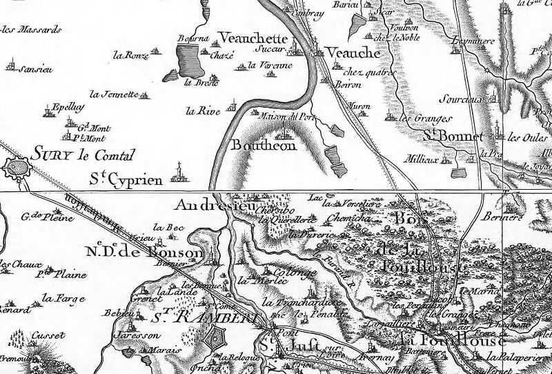
Français : Carte de Cassini (XVIIIe siècle) : extrait montrant la région d'Andrézieux-Bouthéon avec Saint-Rambert et Saint-Just au sud; la Fouillouse au sud-est, Saint-Bonnet (Saint-Bonnet-les-Oules) à l'est, Veauche et Veauchette au nord; Saint-Cyprien et Sury-le-Comtal vers l'ouest. |
| 日期 | 18世纪 |
| 来源 | Géoportail : http://www.geoportail.gouv.fr/accueil |
| 作者 | Cassini |
许可协议
[编辑].jpg&action=edit§ion=2)
|
这是一个平面公有领域艺术品的忠实摄影副本。原艺术品本身因为下列原因属于公有领域:
维基媒体基金会的官方立场认为:“对平面公有领域艺术品的忠实再制作品也属于公有领域。” 因此,可以认为此摄影副本在美国也属于公有领域。在其他司法管辖区,再利用此内容可能存在限制;参见再利用PD-Art照片了解详细信息。 {{PD-Art}} template without license parameter: please specify why the underlying work is public domain in both the source country and the United States
(Usage: {{PD-Art|1=|deathyear=''year of author's death''|country=''source country''}}, where parameter 1= can be PD-old-auto, PD-old-auto-expired, PD-old-auto-1996, PD-old-100 or similar. See Commons:Multi-license copyright tags for more information.) | ||||
文件历史
点击某个日期/时间查看对应时刻的文件。
| 日期/时间 | 缩略图 | 大小 | 用户 | 备注 | |
|---|---|---|---|---|---|
| 当前 | 2016年2月29日 (一) 09:17 | | 1,772 × 1,201(1.28 MB) | O-R(留言 | 贡献) | User created page with UploadWizard |
您不可以覆盖此文件。
文件用途
全域文件用途
以下其他wiki使用此文件:
- fr.wikipedia.org上的用途
- nl.wikipedia.org上的用途
- zh.wikipedia.org上的用途
.jpg&oldid=879043605)