File:Angleseymôncloseup.png
跳至導覽
跳至搜尋
無更高解析度可提供。
Angleseymôncloseup.png (541 × 522 像素,檔案大小:14 KB,MIME 類型:image/png)
說明
說明
添加單行說明來描述出檔案所代表的內容
摘要
[編輯]
| 描述 |
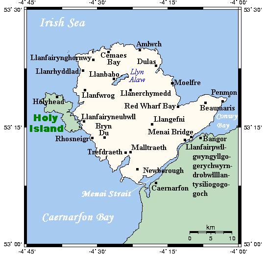
English: A map showing the Isle of Anglesey/Ynys Môn and nearby areas. This map's source is here, with the uploader's modifications, and the GMT homepage says that the tools are released under the GNU General Public License. |
| 日期 | 2007年七月10日 (原始上傳日期) |
| 來源 | Transferred from en.wikipedia to Commons. |
| 作者 | 英文維基百科的Kelisi |
授權條款
[編輯]
| 此檔案採用共享創意 姓名標示-相同方式分享 3.0 未在地化版本授權條款。 受免責聲明的約束。 | ||
| 姓名標示: Kelisi 位于英语维基百科 | ||
| ||
| 已新增授權條款標題至此檔案,作為GFDL授權更新的一部份。 |

|
已授權您依據自由軟體基金會發行的無固定段落、封面文字和封底文字GNU自由文件授權條款1.2版或任意後續版本,對本檔進行複製、傳播和/或修改。該協議的副本列在GNU自由文件授權條款中。 受免責聲明的約束。 |
原始上傳日誌
[編輯]
The original description page was here. All following user names refer to en.wikipedia.
- 2007-07-11 16:08 Kelisi 541×522× (14004 bytes) oops again
- 2007-07-10 23:02 Kelisi 542×522× (13753 bytes) oops
- 2007-07-10 22:53 Kelisi 542×522× (13770 bytes) == Summary == A map showing the Isle of Anglesey/Ynys Môn and nearby areas. This map's source is [http://www.aquarius.ifm-geomar.de/ here], with the uploader's modifications, and the [http://gmt.soest.hawaii.edu/ GMT homepage] says that the tools are rel
檔案歷史
點選日期/時間以檢視該時間的檔案版本。
| 日期/時間 | 縮圖 | 尺寸 | 用戶 | 備註 | |
|---|---|---|---|---|---|
| 目前 | 2013年4月6日 (六) 15:20 | | 541 × 522(14 KB) | OgreBot(對話 | 貢獻) | (BOT): Reverting to most recent version before archival |
| 2013年4月6日 (六) 15:20 |  | 542 × 522(13 KB) | OgreBot(對話 | 貢獻) | (BOT): Uploading old version of file from en.wikipedia; originally uploaded on 2007-07-10 23:02:09 by Kelisi | |
| 2013年4月6日 (六) 15:20 |  | 542 × 522(13 KB) | OgreBot(對話 | 貢獻) | (BOT): Uploading old version of file from en.wikipedia; originally uploaded on 2007-07-10 22:53:32 by Kelisi | |
| 2013年4月5日 (五) 19:26 |  | 541 × 522(14 KB) | Hogweard(對話 | 貢獻) | == {{int:filedesc}} == {{Information |Description={{en|A map showing the Isle of Anglesey/Ynys Môn and nearby areas. This map's source is [http://www.aquarius.ifm-geomar.de/ here], with the uploader's modifications, and the [http://gmt.soest.hawaii.ed... |
無法覆蓋此檔案。
檔案用途
沒有使用此檔案的頁面。
全域檔案使用狀況
以下其他 wiki 使用了這個檔案:
- de.wikipedia.org 的使用狀況
- el.wikipedia.org 的使用狀況
- en.wikipedia.org 的使用狀況
- fi.wikipedia.org 的使用狀況
- fr.wikipedia.org 的使用狀況
- nl.wikipedia.org 的使用狀況
- pl.wikipedia.org 的使用狀況
- zh.wikipedia.org 的使用狀況