File:Antarctic-Convergence-Map.TIF
跳至導覽
跳至搜尋

此 TIF 檔案的 PNG 預覽的大小:514 × 600 像素。 其他解析度:206 × 240 像素 | 411 × 480 像素 | 658 × 768 像素 | 878 × 1,024 像素 | 2,373 × 2,768 像素。
原始檔案 (2,373 × 2,768 像素,檔案大小:898 KB,MIME 類型:image/tiff)
說明
說明
添加單行說明來描述出檔案所代表的內容
Map of the Antarctic Convergence and the Antarctic region
摘要
[編輯]| 描述 | Map of the Antarctic Convergence and the Antarctic region. |
| 日期 | |
| 來源 |
Published in: L. Ivanov and N. Ivanova. The World of Antarctica. Generis Publishing, 2022. p. 14. ISBN 979-8-88676-403-1 Original Bulgarian version published in: Ivanov, L. and N. Ivanova. Antarctic: Nature, History, Utilization, Geographic Names and Bulgarian Participation. Sofia: Manfred Wörner Foundation, 2014. p. 9 (in Bulgarian) ISBN 978-619-90008-1-6 |
| 作者 | own work |
| 其他版本 | File:Antarctic-Overview-Map.tif, https://commons.wikimedia.org/wiki/File:Antarctic-Overview-Map-EN.tif |
Copyright owner Lyubomir Ivanov alias Apcbg per File:Antarctica-Book-368.TIF.

|
File:Antarctica and the Southern Ocean.svg是本檔案的向量版本。 如果品質不低,就應該優先使用該檔案,而非TIF檔案。
File:Antarctic-Convergence-Map.TIF → File:Antarctica and the Southern Ocean.svg
更多資訊請參閱Help:SVG/zh。 |
 |
授權條款
[編輯]此檔案採用共享創意 姓名標示-相同方式分享 3.0 未在地化版本授權條款。
- 您可以自由:
- 分享 – 複製、發佈和傳播本作品
- 重新修改 – 創作演繹作品
- 惟需遵照下列條件:
- 姓名標示 – 您必須指名出正確的製作者,和提供授權條款的連結,以及表示是否有對內容上做出變更。您可以用任何合理的方式來行動,但不得以任何方式表明授權條款是對您許可或是由您所使用。
- 相同方式分享 – 如果您利用本素材進行再混合、轉換或創作,您必須基於如同原先的相同或兼容的條款,來分布您的貢獻成品。
檔案歷史
點選日期/時間以檢視該時間的檔案版本。
| 日期/時間 | 縮圖 | 尺寸 | 用戶 | 備註 | |
|---|---|---|---|---|---|
| 目前 | 2022年11月27日 (日) 09:20 |  | 2,373 × 2,768(898 KB) | Apcbg(對話 | 貢獻) | style |
| 2022年11月26日 (六) 19:03 |  | 2,373 × 2,768(898 KB) | Apcbg(對話 | 貢獻) | typo fixed | |
| 2014年8月13日 (三) 10:30 |  | 2,373 × 2,768(980 KB) | Apcbg(對話 | 貢獻) | Alexander Island | |
| 2014年8月12日 (二) 12:16 | 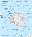 | 2,373 × 2,768(978 KB) | Apcbg(對話 | 貢獻) | {{Information |Description=Map of the Antarctic Convergence. |Source=Ivanov, L. and N. Ivanova. Antarctic: Nature, History, Utilization, Geographic Names and Bulgarian Participation. Sofia: Manfred Wörner Foundation, 2014. p. 9 (in Bulgarian) ISBN 97... |
無法覆蓋此檔案。
檔案用途
全域檔案使用狀況
以下其他 wiki 使用了這個檔案:
- bg.wikipedia.org 的使用狀況
- de.wikipedia.org 的使用狀況
- en.wikipedia.org 的使用狀況
- en.wikivoyage.org 的使用狀況
- es.wikipedia.org 的使用狀況
- eu.wikipedia.org 的使用狀況
- fa.wikipedia.org 的使用狀況
- gl.wikipedia.org 的使用狀況
- id.wikipedia.org 的使用狀況
- ko.wikipedia.org 的使用狀況
- lb.wikipedia.org 的使用狀況
- lt.wikipedia.org 的使用狀況
- mk.wikipedia.org 的使用狀況
- ru.wikipedia.org 的使用狀況
- uk.wikipedia.org 的使用狀況
- www.wikidata.org 的使用狀況