File:Antarctic Peninsula, the Larsen Ice Shelf, and the sea ice covered waters around the region.jpg
跳至導覽
跳至搜尋

預覽大小:468 × 599 像素。 其他解析度:187 × 240 像素 | 375 × 480 像素 | 600 × 768 像素 | 800 × 1,024 像素 | 1,600 × 2,048 像素 | 5,000 × 6,400 像素。
原始檔案 (5,000 × 6,400 像素,檔案大小:4.51 MB,MIME 類型:image/jpeg)
說明
說明
添加單行說明來描述出檔案所代表的內容
摘要
[編輯]
| 描述 |
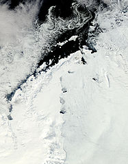
English: Clear view of the Antarctic Peninsula, the Larsen Ice Shelf, and the sea ice covered waters around the region. The Peninsula stands out as the raised terrain amidst the ice from the lower left to upper middle of the image. |
| 日期 | |
| 來源 | NASA Earth Observatory |
| 作者 | Jeff Schmaltz |
Image captured by the Moderate Resolution Imaging Spectroradiometer (MODIS) on NASA’s Aqua satellite. NASA image provided courtesy of the MODIS Rapid Response team.
授權條款
[編輯]
| 本作品由NASA創作,屬於公有領域。根據NASA的版權政策:“NASA的創作除非另有聲明否則不受版權保護。”(參見:Template:PD-USGov/zh,NASA版權政策或JPL圖像使用政策) | ||
 |
警告:
|
| 註解 | 該圖片含有註解:在維基媒體共享資源上查看註解 |
檔案歷史
點選日期/時間以檢視該時間的檔案版本。
| 日期/時間 | 縮圖 | 尺寸 | 用戶 | 備註 | |
|---|---|---|---|---|---|
| 目前 | 2011年10月17日 (一) 12:15 | | 5,000 × 6,400(4.51 MB) | Originalwana(對話 | 貢獻) | {{Information |Description ={{en|1=Clear view of the Antarctic Peninsula, the Larsen Ice Shelf, and the sea ice covered waters around the region. The Peninsula stands out as the raised terrain amidst the ice from the lower left to upper middle of t |
無法覆蓋此檔案。
檔案用途
沒有使用此檔案的頁面。
全域檔案使用狀況
以下其他 wiki 使用了這個檔案:
- ar.wikipedia.org 的使用狀況
- cs.wikipedia.org 的使用狀況
- en.wikipedia.org 的使用狀況
- fa.wikipedia.org 的使用狀況
- ko.wikipedia.org 的使用狀況
- la.wikipedia.org 的使用狀況
- mk.wikipedia.org 的使用狀況
- ms.wikipedia.org 的使用狀況
- nn.wikipedia.org 的使用狀況
- pl.wikipedia.org 的使用狀況
- pt.wikipedia.org 的使用狀況
- ta.wikipedia.org 的使用狀況
- uk.wikipedia.org 的使用狀況
- zh.wikipedia.org 的使用狀況