File:Antarctica.CIA.svg
跳去導覽
跳去搵嘢

呢個「SVG」檔案嘅呢個「PNG」預覽嘅大細:480 × 599 像素。 第啲解像度:192 × 240 像素 | 385 × 480 像素 | 615 × 768 像素 | 820 × 1,024 像素 | 1,641 × 2,048 像素 | 512 × 639 像素。
原本檔案 (SVG檔案,表面大細: 512 × 639 像素,檔案大細:1.05 MB)
Captions
Captions
Add a one-line explanation of what this file represents
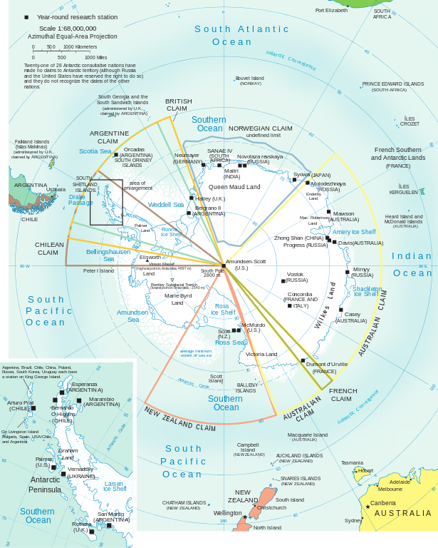
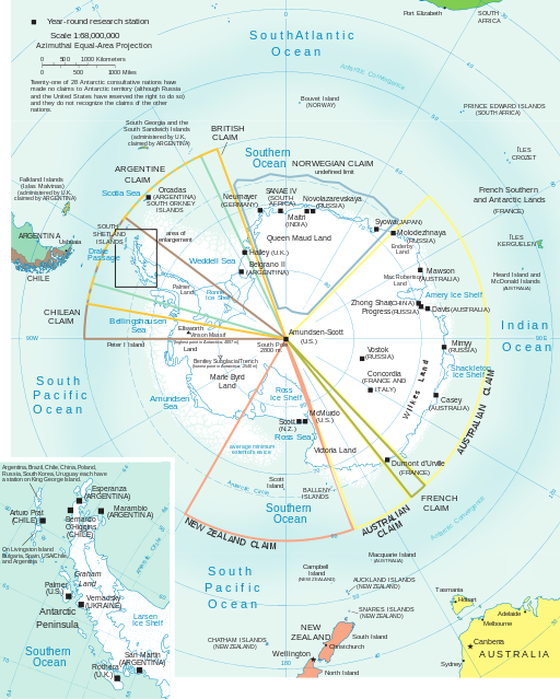
| 描述 | Antarctica map | |||
| 來源 | CIA World Factbook Antarctic Region (PDF). Archived from the original on 2012-05-18. | |||
| 作者 | CIA | |||
| 許可 (重用呢個檔案) |
|
|||
| Other versions | Derivative works of this file: Shackleton Endurance Aurora map.svg |

檔案歷史
撳個日期/時間去睇響嗰個時間出現過嘅檔案。
| 日期/時間 | 縮圖 | 尺寸 | 用戶 | 註解 | |
|---|---|---|---|---|---|
| 現時 | 2012年2月18號 (六) 20:52 | | 512 × 639(1.05 MB) | Ras67(傾偈 | 貢獻) | http://commons.wikimedia.org/wiki/User_talk:Ras67#Antarctica |
| 2010年12月3號 (五) 00:21 |  | 512 × 639(1.04 MB) | Ras67(傾偈 | 貢獻) | cropped, font imagining repaired | |
| 2008年10月20號 (一) 18:41 |  | 612 × 792(1.21 MB) | RaviC(傾偈 | 貢獻) | Better SVGed version by myself | |
| 2008年1月5號 (六) 23:35 |  | 744 × 1,052(4.06 MB) | Sasha Krotov(傾偈 | 貢獻) | Reverted to version as of 22:40, 5 January 2008 | |
| 2008年1月5號 (六) 23:34 |  | 744 × 1,052(4.17 MB) | Sasha Krotov(傾偈 | 貢獻) | test crop | |
| 2008年1月5號 (六) 22:40 |  | 744 × 1,052(4.06 MB) | Sasha Krotov(傾偈 | 貢獻) | test fix | |
| 2008年1月5號 (六) 22:09 |  | 744 × 1,052(4.06 MB) | Sasha Krotov(傾偈 | 貢獻) | {{Information |Description=Antarctica map |Source=[https://www.cia.gov/library/publications/the-world-factbook/reference_maps/pdf/antarctic.pdf CIA World Factbook] |Date= |Author= CIA |Permission={{PD-USGov-CIA-WF}} |other_versions= }} == License == [[ |
你無得衾咗個檔案。
檔案用途
以下嘅13版用到呢個檔:
- File:Antarctica.jpg
- File:Antarctica ua.jpg
- File:Auckland Islands in Antarctica (extended).svg
- File:Bouvet Island in Antarctica (extended).svg
- File:British Antarctic Territory in Antarctica (extended).svg
- File:Campbell Island in Antarctica (extended).svg
- File:Falkland Islands in Antarctica (extended).svg
- File:French Southern Territories in Antarctica (extended).svg
- File:Heard Island and McDonald Islands in Antarctica (extended).svg
- File:Macquarie Island in Antarctica (extended).svg
- File:Prince Edward Islands in Antarctica (extended).svg
- File:Shackleton Endurance Aurora map.svg
- File:South Georgia and the South Sandwich Islands in Antarctica (extended).svg
.svg)
.svg)
.svg)
.svg)
.svg)
.svg)
.svg)
.svg)
.svg)
.svg)
全域檔案使用情況
下面嘅維基都用緊呢個檔案:
- ast.wikipedia.org嘅使用情況
- az.wikipedia.org嘅使用情況
- be.wikipedia.org嘅使用情況
- ca.wikipedia.org嘅使用情況
- cs.wikipedia.org嘅使用情況
- el.wikipedia.org嘅使用情況
- es.wikipedia.org嘅使用情況
- es.wikivoyage.org嘅使用情況
- fi.wikipedia.org嘅使用情況
- fr.wikipedia.org嘅使用情況
- gl.wikipedia.org嘅使用情況
- hu.wikipedia.org嘅使用情況
- hy.wikipedia.org嘅使用情況
- it.wikipedia.org嘅使用情況
- ja.wikipedia.org嘅使用情況
- ka.wikipedia.org嘅使用情況
- mhr.wikipedia.org嘅使用情況
- mk.wikipedia.org嘅使用情況
- pl.wikipedia.org嘅使用情況
- Ziemia Królowej Maud
- Roszczenia terytorialne na Antarktydzie
- Ziemia Marii Byrd
- Dependencja Rossa
- Ziemia Adeli
- Czwórstyk
- Wikipedysta:Malarz pl/szablony/Państwo infobox
- Wikipedysta:Malarz pl/szablony/Państwo infobox/11
- Wikipedysta:Malarz pl/szablony/Państwo infobox/12
- Wikipedysta:Malarz pl/szablony/Państwo infobox/13
睇呢個檔案嘅更多全域使用情況。