File:Antietam0730.png
跳至導覽
跳至搜尋
預覽大小:480 × 600 像素。 其他解析度:192 × 240 像素 | 384 × 480 像素 | 614 × 768 像素 | 819 × 1,024 像素 | 1,638 × 2,048 像素 | 4,800 × 6,000 像素。
原始檔案 (4,800 × 6,000 像素,檔案大小:14.35 MB,MIME 類型:image/png)
說明
說明
添加單行說明來描述出檔案所代表的內容
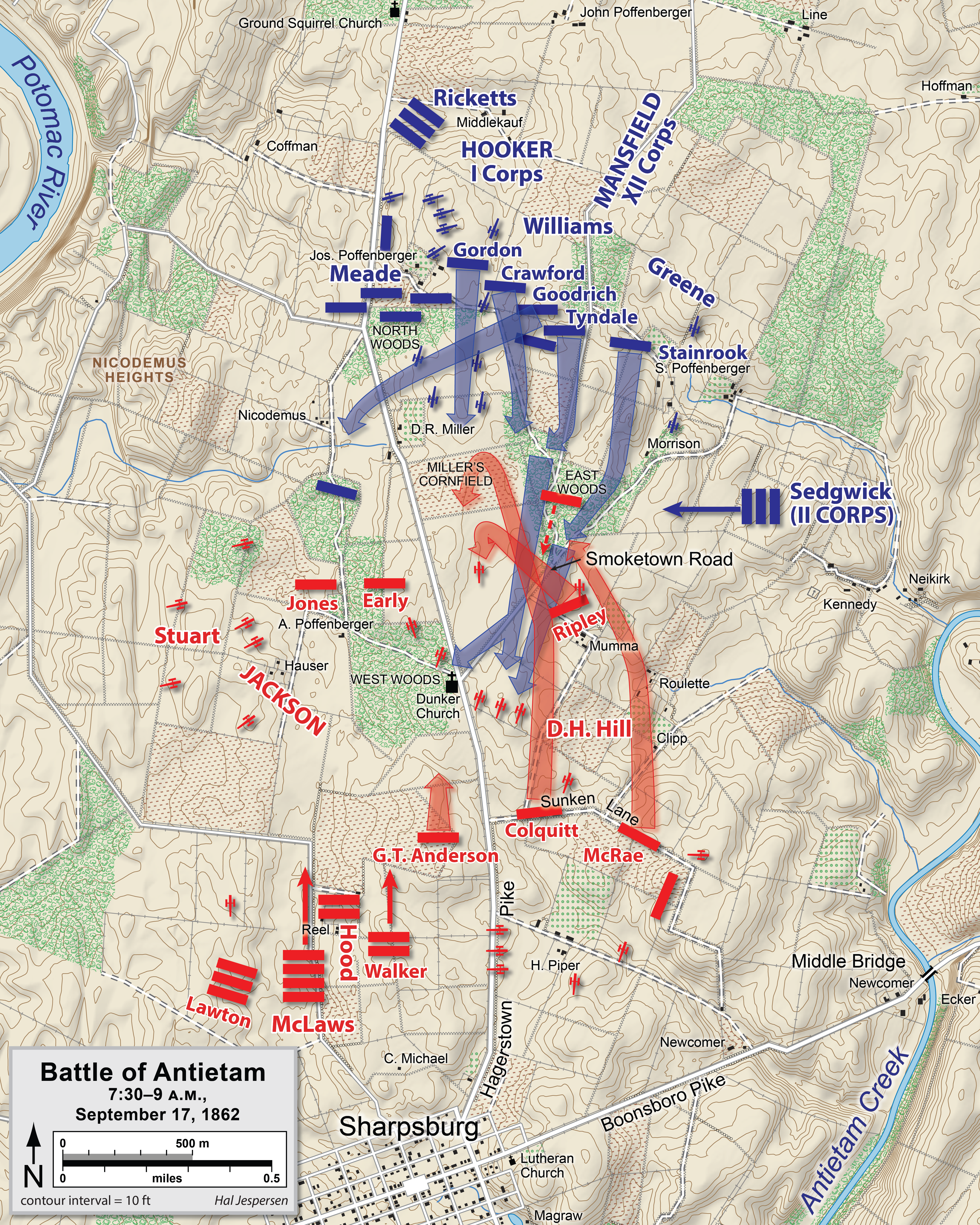
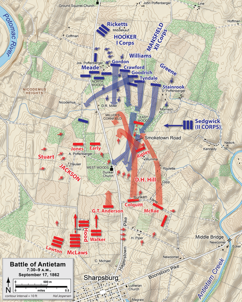
| 描述 | Map of the Battle of Antietam of the American Civil War. Drawn in Adobe Illustrator CS5 by Hal Jespersen. Graphic source file is available at http://www.posix.com/CWmaps/ |
| 日期 | |
| 來源 | 自己的作品 |
| 作者 | Hal Jespersen |
此檔案採用創用CC 姓名標示 3.0 未在地化版本授權條款。
姓名標示: Map by Hal Jespersen, www.posix.com/CW
- 您可以自由:
- 分享 – 複製、發佈和傳播本作品
- 重新修改 – 創作演繹作品
- 惟需遵照下列條件:
- 姓名標示 – 您必須指名出正確的製作者,和提供授權條款的連結,以及表示是否有對內容上做出變更。您可以用任何合理的方式來行動,但不得以任何方式表明授權條款是對您許可或是由您所使用。

|
File:Antietam0730 a.svg是本檔案的向量版本。 如果品質不低,就應該優先使用該檔案,而非PNG檔案。
File:Antietam0730.png → File:Antietam0730 a.svg
更多資訊請參閱Help:SVG/zh。 |
 |
檔案歷史
點選日期/時間以檢視該時間的檔案版本。
| 日期/時間 | 縮圖 | 尺寸 | 使用者 | 備註 | |
|---|---|---|---|---|---|
| 目前 | 2023年1月26日 (四) 21:40 | | 4,800 × 6,000(14.35 MB) | Hlj(留言 | 貢獻) | improved graphics and detail |
| 2011年9月27日 (二) 21:25 |  | 789 × 935(320 KB) | Hlj(留言 | 貢獻) | Provide more exact topographical information. Same license. | |
| 2011年3月28日 (一) 19:49 |  | 794 × 957(218 KB) | Hlj(留言 | 貢獻) | Update to more recent graphical style for rivers and roads. Same license. | |
| 2010年10月26日 (二) 01:19 |  | 794 × 957(197 KB) | Hlj(留言 | 貢獻) | Updated graphics to conform to style used by many other ACW maps, added legend/scale. Drawn in Adobe Illustrator CS5 by Hal Jespersen. Graphic source file is available at http://www.posix.com/CWmaps/ {{cc-by-3.0|Map by Hal Jespersen, www.posix.com/CW}} | |
| 2007年4月15日 (日) 09:12 |  | 755 × 921(223 KB) | Hellisp(留言 | 貢獻) | Map of the Battle of Antietam of the American Civil War, actions starting at 7.30 a.m. Drawn by Hal Jespersen in Macromedia Freehand. Graphic source file is available at http://www.posix.com/CWmaps/ {{PD-release}} From en.wikipedia.org http://en.wikiped |
無法覆蓋此檔案。
檔案用途
下列3個頁面有用到此檔案:
全域檔案使用狀況
以下其他 wiki 使用了這個檔案:
- ast.wikipedia.org 的使用狀況
- azb.wikipedia.org 的使用狀況
- ca.wikipedia.org 的使用狀況
- da.wikipedia.org 的使用狀況
- en.wikipedia.org 的使用狀況
- es.wikipedia.org 的使用狀況
- hu.wikipedia.org 的使用狀況
- it.wikipedia.org 的使用狀況
- ja.wikipedia.org 的使用狀況
- ko.wikipedia.org 的使用狀況
- la.wikipedia.org 的使用狀況
- ms.wikipedia.org 的使用狀況
- pl.wikipedia.org 的使用狀況
- ro.wikipedia.org 的使用狀況
- zh.wikipedia.org 的使用狀況