File:AppalachianLocatorMap2.png
跳至導覽
跳至搜尋
無更高解析度可提供。
AppalachianLocatorMap2.png (637 × 424 像素,檔案大小:84 KB,MIME 類型:image/png)
說明
說明
添加單行說明來描述出檔案所代表的內容

摘要[編輯]
| 描述 |
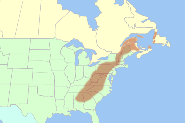
English: Inaccurate map of the Appalachian Mountains shown in the Eastern United States and Eastern Canada. |
| 日期 | 2007年九月12日 (原始上傳日期) |
| 來源 | Transferred from en.wikipedia to Commons. |
| 作者 | 英文維基百科的Lanma726 |
授權條款[編輯]
| 此作品已由其作者,英文維基百科的Lanma726,釋出至公有領域。此授權條款在全世界均適用。 這可能在某些國家不合法,如果是的話: Lanma726授予任何人有權利使用此作品於任何用途,除受法律約束外,不受任何限制。 |
授權條款[編輯]
| 我,此作品的版權所有人,釋出此作品至公共領域。此授權條款在全世界均適用。 這可能在某些國家不合法,如果是的話: 我授予任何人有權利使用此作品於任何用途,除受法律約束外,不受任何限制。 |
| 註解 | 該圖片含有註解:在維基媒體共享資源上查看註解 |
檔案歷史
點選日期/時間以檢視該時間的檔案版本。
| 日期/時間 | 縮圖 | 尺寸 | 用戶 | 備註 | |
|---|---|---|---|---|---|
| 目前 | 2017年8月24日 (四) 21:03 | | 637 × 424(84 KB) | YanikB(對話 | 貢獻) | Add locations of mountains part of Appalachians. |
| 2017年8月23日 (三) 11:42 |  | 637 × 424(84 KB) | YanikB(對話 | 貢獻) | Add location of mountains part of Appalachians. | |
| 2008年5月1日 (四) 09:38 |  | 637 × 424(84 KB) | Urdangaray(對話 | 貢獻) | {{Information |Description={{en|Lanma726 56}} |Source=Transferred from [http://en.wikipedia.org en.wikipedia] |Date=2007-09-12 (original upload date) |Author=Original uploader was Lanma726 at [http://en.wikipedia.org en.wikipedia] |P |
無法覆蓋此檔案。
檔案用途
下列4個頁面有用到此檔案:
全域檔案使用狀況
以下其他 wiki 使用了這個檔案:
- af.wikipedia.org 的使用狀況
- arz.wikipedia.org 的使用狀況
- ba.wikipedia.org 的使用狀況
- br.wikipedia.org 的使用狀況
- bs.wikipedia.org 的使用狀況
- ca.wikipedia.org 的使用狀況
- cs.wikipedia.org 的使用狀況
- de.wikipedia.org 的使用狀況
- de.wiktionary.org 的使用狀況
- en.wikipedia.org 的使用狀況
- eo.wikipedia.org 的使用狀況
- es.wikipedia.org 的使用狀況
- es.wikibooks.org 的使用狀況
- eu.wikipedia.org 的使用狀況
- fi.wikipedia.org 的使用狀況
- fi.wiktionary.org 的使用狀況
- fo.wikipedia.org 的使用狀況
- frr.wikipedia.org 的使用狀況
- fr.wikipedia.org 的使用狀況
- fy.wikipedia.org 的使用狀況
- ga.wikipedia.org 的使用狀況
- gl.wikipedia.org 的使用狀況
- he.wikivoyage.org 的使用狀況
- hi.wikipedia.org 的使用狀況
- hr.wikipedia.org 的使用狀況
- id.wikipedia.org 的使用狀況
- it.wikipedia.org 的使用狀況
- ja.wikipedia.org 的使用狀況
- ja.wikibooks.org 的使用狀況
- kk.wikipedia.org 的使用狀況
- ko.wikipedia.org 的使用狀況
- ky.wikipedia.org 的使用狀況
- la.wikipedia.org 的使用狀況
- lfn.wikipedia.org 的使用狀況
- ms.wikipedia.org 的使用狀況
- nl.wikipedia.org 的使用狀況
- nn.wikipedia.org 的使用狀況
- no.wikipedia.org 的使用狀況
- pl.wikipedia.org 的使用狀況
- pl.wiktionary.org 的使用狀況
檢視此檔案的更多全域使用狀況。