File:AquaMap Diver LBL Acoustic Positioning Equipment.jpg
Salta a la navegació
Salta a la cerca

Mida d'aquesta previsualització: 520 × 600 píxels. Altres resolucions: 208 × 240 píxels | 416 × 480 píxels | 780 × 900 píxels.
Fitxer original (780 × 900 píxels, mida del fitxer: 703 Ko, tipus MIME: image/jpeg)
Llegendes
Llegendes
Afegeix una explicació d'una línia del que representa aquest fitxer
Resum
[modifica]
| Descripció |
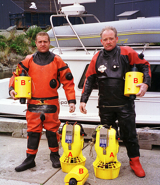
English: Dive team (Envirotech Divers) with an AquaMap long-baseline (LBL) acoustic positioning system. The three baseline transponders (B) are deployed prior to a dive and serve as the reference points for navigation. Using a short (2m) anchor line and a weight, they are secured to the seafloor. If repeat surveys need to be done over a period of time to monitor changes, the preferred technique is to establish a 'monument' at each baseline station location and secure the baseline station to that monument each time to minimize positioning variability. A monument may be a block of concrete, a railroad wheel or another heavy object. It may also be a distinctive natural feature such as a boulder. The divers navigate and record position using a terminal (A) similar to a GPS receiver. The terminal receives positioning data (baseline station distance and depth measurements) either from an integrated acoustic transponder, such as in the DS-1 station shown here, or from an external transponder. |
| Data | |
| Font | Treball propi |
| Autor | Desertstar |
| Permís (Com reutilitzar aquest fitxer) |
Desert Star permission |
Llicència
[modifica]
Jo, el titular dels drets d'autor d'aquest treball, el public sota la següent llicència:
Aquest fitxer està subjecte a la llicència de Creative Commons Reconeixement 3.0 No adaptada.
- Sou lliure de:
- compartir – copiar, distribuir i comunicar públicament l'obra
- adaptar – fer-ne obres derivades
- Amb les condicions següents:
- reconeixement – Heu de donar la informació adequada sobre l'autor, proporcionar un enllaç a la llicència i indicar si s'han realitzat canvis. Podeu fer-ho amb qualsevol mitjà raonable, però de cap manera no suggereixi que l'autor us dóna suport o aprova l'ús que en feu.
Historial del fitxer
Cliqueu una data/hora per veure el fitxer tal com era aleshores.
| Data/hora | Miniatura | Dimensions | Usuari/a | Comentari | |
|---|---|---|---|---|---|
| actual | 20:57, 17 maig 2009 | | 780 × 900 (703 Ko) | Desertstar (discussió | contribucions) | {{Information |Description={{en|1=Dive team (Envirotech Divers) with an AquaMap long-baseline (LBL) acoustic positioning system. The three baseline transponders (B) are deployed prior to a dive and serve as the reference points for navigation. Using a sh |
No podeu sobreescriure aquest fitxer.
Ús del fitxer
No hi ha pàgines que utilitzin aquest fitxer.
Ús global del fitxer
Utilització d'aquest fitxer en altres wikis:
- Utilització a ca.wikipedia.org
- Utilització a en.wikipedia.org
- Utilització a es.wikipedia.org
- Utilització a fr.wikipedia.org