File:Arctic sea ice reaches lowest maximum extent on record.png
Ir a la navegación
Ir a la búsqueda

Tamaño de esta previsualización: 750 × 600 píxeles. Otras resoluciones: 300 × 240 píxeles | 600 × 480 píxeles | 960 × 768 píxeles | 1050 × 840 píxeles.
Archivo original (1050 × 840 píxeles; tamaño de archivo: 329 kB; tipo MIME: image/png)
Leyendas
Leyendas
Añade una explicación corta acerca de lo que representa este archivo
Resumen
[editar]
| Descripción |
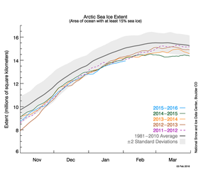
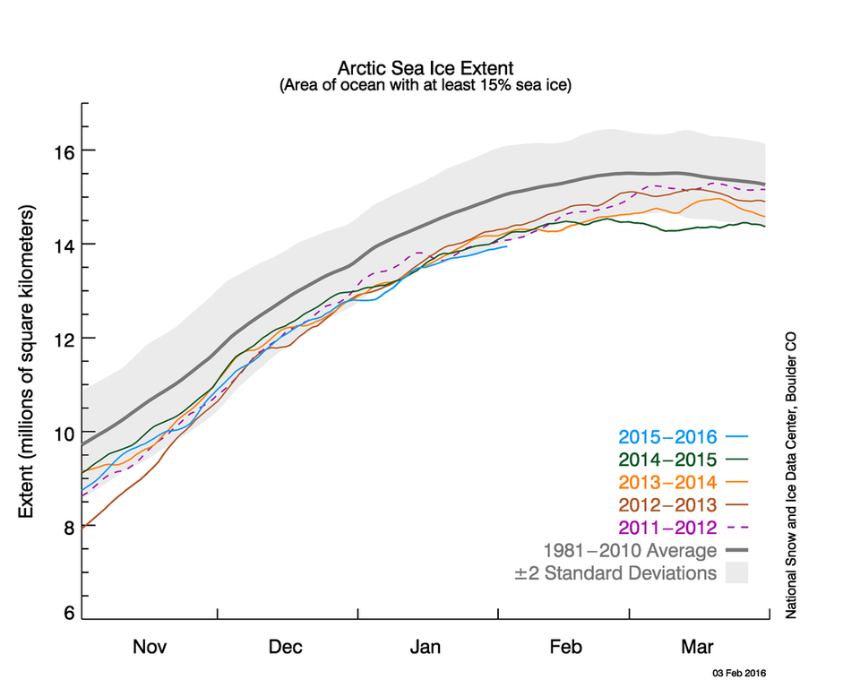
English: The graph above shows Arctic sea ice extent as of February 3, 2016, along with daily ice extent data for four previous years. 2015 to 2016 is shown in blue, 2014 to 2015 in green, 2013 to 2014 in orange, 2012 to 2011 in brown, and 2011 to 2012 in purple. The 1981 to 2010 average is in dark gray. The gray area around the average line shows the two standard deviation range of the data.
January Arctic sea ice extent was the lowest in the satellite record, attended by unusually high air temperatures over the Arctic Ocean and a strong negative phase of the Arctic Oscillation (AO) for the first three weeks of the month. Credit: National Snow and Ice Data Center |
| Fecha | |
| Fuente | http://nsidc.org/arcticseaicenews/2016/02/january-hits-new-record-low-in-the-arctic/ National Snow and Ice Data Center |
| Autor | NSIDC |
Licencia
[editar]
| Este archivo es de dominio público porque fue creado por la NASA. Las políticas sobre copyright de la NASA estipulan que «el material de la NASA no está protegido con copyright a menos que se indique lo contrario». (Políticas sobre copyright de la NASA o Políticas sobre la utilización de imágenes del Jet Propulsion Laboratory). | ||
 |
Advertencias:
|
Historial del archivo
Haz clic sobre una fecha y hora para ver el archivo tal como apareció en ese momento.
| Fecha y hora | Miniatura | Dimensiones | Usuario | Comentario | |
|---|---|---|---|---|---|
| actual | 02:46 6 feb 2016 | | 1050 × 840 (329 kB) | Prokaryotes (discusión | contribs.) | The graph above shows Arctic sea ice extent as of February 3, 2016, along with daily ice extent data for four previous years. 2015 to 2016 is shown in blue, 2014 to 2015 in green, 2013 to 2014 in orange, 2012 to 2011 in brown, and 2011 to 2012 in purpl... |
| 17:36 16 may 2015 |  | 1050 × 840 (344 kB) | Prokaryotes (discusión | contribs.) | User created page with UploadWizard |
No puedes sobrescribir este archivo.
Usos del archivo
No hay páginas que enlacen a este archivo.
Uso global del archivo
Las wikis siguientes utilizan este archivo:
- Uso en es.wikipedia.org
- Uso en vi.wikipedia.org