File:Ardf map.png
Ardf_map.png (600 × 550 pixels, taille du fichier : 430 kio, type MIME : image/png)
Légendes
Légendes
source/author[modifier]
Description[modifier]
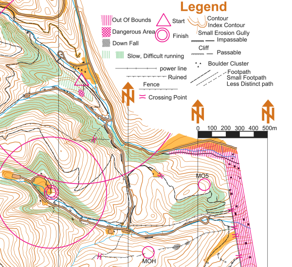
On this portion of an ARDF map, the start location is indicated by a triangle and the finish location is indicated by two concentric circles. The locations of two of the five transmitters are indicated on this version of the map with circles and the labels MOH and MO5 - on the versions of the map given to competitors, the locations of the transmitters are not indicated.
This map is a portion of the Cibola National Forest in the Sandia Mountains east of Albuquerque, New Mexico, USA. The map was used for the eighty meter competition of the Third IARU Region II ARDF Championship, August 5, 2005. This map is not created to International Orienteering Federation standards for orienteering maps.
The map was created in 2005 by Jerry Boyd of Albuquerque, New Mexico, with field checking by Gail Boyd, Taylor Boyd, Jack Stump, Scott Stevenson, and Jerry Boyd. Contact information for these individuals is available at the Albuquerque Transmitter Hunters copie d'archive sur Wayback Machine web site. This image of the map has been released under GFDL by its author, Jerry Boyd, and is used with permission.
A subsequent map of the same terrain has been created from scratch by professional mapmakers working on behalf of New Mexico Orienteers copie d'archive sur Wayback Machine. Work on that map began in 2005, after the completion of the 2005 IARU Region II ARDF Championship.
Conditions d’utilisation[modifier]
| Ce fichier est disponible selon les termes de la licence Creative Commons Attribution – Partage dans les Mêmes Conditions 3.0 (non transposée). Sujet aux avertissements. | ||
| ||
| Ce bandeau de licence a été ajouté à ce fichier dans le cadre de la procédure de mise à jour des licences des images sous GFDL. |

|
Vous avez la permission de copier, distribuer et modifier ce document selon les termes de la GNU Free Documentation License version 1.2 ou toute version ultérieure publiée par la Free Software Foundation, sans sections inaltérables, sans texte de première page de couverture et sans texte de dernière page de couverture. Un exemplaire de la licence est inclus dans la section intitulée GNU Free Documentation License. Sujet aux avertissements. |
Historique du fichier
Cliquer sur une date et heure pour voir le fichier tel qu'il était à ce moment-là.
| Date et heure | Vignette | Dimensions | Utilisateur | Commentaire | |
|---|---|---|---|---|---|
| actuel | 12 mars 2006 à 20:46 | | 600 × 550 (430 kio) | Greudin (d | contributions) | == Summary == On this portion of an ARDF map, the start location is indicated by a triangle and the finish location is indicated by two concentric circles. The locations of two of the five transmitters are indicated on |
Vous ne pouvez pas remplacer ce fichier.
Utilisations locales du fichier
Aucune page n’utilise ce fichier.
Utilisations du fichier sur d’autres wikis
Les autres wikis suivants utilisent ce fichier :
- Utilisation sur cs.wikipedia.org
- Utilisation sur en.wikipedia.org
- Utilisation sur en.wikibooks.org
- Utilisation sur en.wikiversity.org
- Utilisation sur en.wikivoyage.org
- Utilisation sur fr.wikipedia.org
- Utilisation sur pl.wikipedia.org
- Utilisation sur sk.wikipedia.org
- Utilisation sur zh-yue.wikipedia.org
- Utilisation sur zh.wikipedia.org