File:Armenian population map 1896.jpg
跳至導覽
跳至搜尋

預覽大小:722 × 599 像素。 其他解析度:289 × 240 像素 | 578 × 480 像素 | 925 × 768 像素 | 1,234 × 1,024 像素 | 2,468 × 2,048 像素 | 2,964 × 2,460 像素。
原始檔案 (2,964 × 2,460 像素,檔案大小:2.88 MB,MIME 類型:image/jpeg)
說明
說明
添加單行說明來描述出檔案所代表的內容
|
|

摘要
[編輯]
| 描述 |
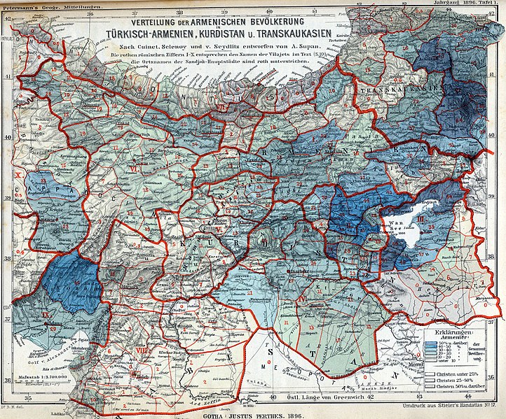
English: The Armenian population in historical Armenian regions in 1896. The Armenian population is represented in the colored areas, as well as in the red Arabic numbers, indicating their exact percentage. |
| 日期 | |
| 來源 | Petermanns Geographische Mitteilungen |
| 作者 | own scan |
| 其他版本 |
Derivative works of this file: |
授權條款
[編輯]
| 此作品無已知的著作權限制,亦不受所有相關和鄰接的權利限制。 | |
|
公有領域作品必須在美國以及來源國沒有版權問題,才能上傳至維基共享資源。如果此作品不是美國作品,這個文件必須要有一個額外的版權標記顯示此文件在來源國的版權狀態。
注意:此標籤不應用於錄音作品。 |
檔案歷史
點選日期/時間以檢視該時間的檔案版本。
| 日期/時間 | 縮圖 | 尺寸 | 用戶 | 備註 | |
|---|---|---|---|---|---|
| 目前 | 2009年11月15日 (日) 15:41 | | 2,964 × 2,460(2.88 MB) | Alex:D(對話 | 貢獻) | whitened |
| 2008年6月14日 (六) 14:57 |  | 2,964 × 2,460(3.96 MB) | Olahus(對話 | 貢獻) | {{Information |Description={{en|1=The Armenian population in hostorical Armenian regions in the year 1896.}} |Source=Petermanns Mitteilungen |Author=own scan |Date=1896 |Permission= |other_versions= }} {{ImageUpload|full}} |
無法覆蓋此檔案。
檔案用途
下列9個頁面有用到此檔案:
- User:Olahus
- Commons:Graphic Lab/Map workshop/Archive/2014
- File:Armenian population map 1896 Erklärungen.jpg
- File:Armenian population map 1896 cropped.jpg
- File:Armenian population map 1896 cropped 2.jpg
- File:Armenian population map 1896 cropped 3.jpg
- File:Armenian population map 1896 cropped Kurdistan.jpg
- File:Armenian population map 1896 cropped Lake Van.jpg
- File:Armenian population map 1896 cropped Lazistan.jpg
全域檔案使用狀況
以下其他 wiki 使用了這個檔案:
- af.wikipedia.org 的使用狀況
- ast.wikipedia.org 的使用狀況
- azb.wikipedia.org 的使用狀況
- ba.wikipedia.org 的使用狀況
- be.wikipedia.org 的使用狀況
- cs.wikipedia.org 的使用狀況
- da.wikipedia.org 的使用狀況
- de.wikipedia.org 的使用狀況
- en.wikipedia.org 的使用狀況
- Decline and modernization of the Ottoman Empire
- Armenian Kingdom of Cilicia
- Ottoman Armenian population
- Armenian national movement
- Armenians in the Ottoman Empire
- User:Olahus
- Demographics of the Ottoman Empire
- Wikipedia:Graphics Lab/Map workshop/Archive/May 2010
- User:Yerevantsi/Sources
- User:C3qiuhao/sandbox
- Talk:Armenian genocide/Archive 28
- User:Falcaorib/Armenia, Azerbaijan and Georgia
- eo.wikipedia.org 的使用狀況
- es.wikipedia.org 的使用狀況
- fr.wikipedia.org 的使用狀況
- fy.wikipedia.org 的使用狀況
- gl.wikipedia.org 的使用狀況
- hy.wikipedia.org 的使用狀況
- hyw.wikipedia.org 的使用狀況
- id.wikipedia.org 的使用狀況
- it.wikipedia.org 的使用狀況
- ja.wikipedia.org 的使用狀況
- ka.wikipedia.org 的使用狀況
- ms.wikipedia.org 的使用狀況
檢視此檔案的更多全域使用狀況。