File:ArnoldExpeditionRouteMarked.jpg
跳至導覽
跳至搜尋

預覽大小:242 × 600 像素。 其他解析度:97 × 240 像素 | 193 × 480 像素 | 310 × 768 像素 | 413 × 1,024 像素 | 2,240 × 5,552 像素。
原始檔案 (2,240 × 5,552 像素,檔案大小:3.07 MB,MIME 類型:image/jpeg)
說明
說明
添加單行說明來描述出檔案所代表的內容
摘要[編輯]
| 描述 |
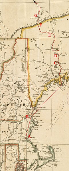
English: This is a detail from a 1795 map depicting the New England states. It is marked with the route of Benedict Arnold's expedition to Quebec City in September 1775.
Legend:
|
| 日期 | base map published by Henry Delahoy Symonds of New England in 1795, markings 2010 |
| 來源 | Source map from the Boston Public Library Map Collection |
| 作者 | John Russell (underlying map), User:Magicpiano (markings) |
授權條款[編輯]
| 我,此作品的版權所有人,釋出此作品至公共領域。此授權條款在全世界均適用。 這可能在某些國家不合法,如果是的話: 我授予任何人有權利使用此作品於任何用途,除受法律約束外,不受任何限制。 |
檔案歷史
點選日期/時間以檢視該時間的檔案版本。
| 日期/時間 | 縮圖 | 尺寸 | 用戶 | 備註 | |
|---|---|---|---|---|---|
| 目前 | 2010年6月18日 (五) 17:08 | 2,240 × 5,552(3.07 MB) | Magicpiano(對話 | 貢獻) | Use a different base map. | |
| 2009年4月19日 (日) 19:21 |  | 2,618 × 4,631(4.21 MB) | Magicpiano(對話 | 貢獻) | {{Information |Description={{en|1=This is a detail from a 1780 map depicting the New England states. It is marked with the route of w:Benedict Arnold's expedition to w:Quebec City in September 1775. Legend: *A: [[w:Camb |
無法覆蓋此檔案。
檔案用途
下列頁面有用到此檔案:
全域檔案使用狀況
以下其他 wiki 使用了這個檔案:
- en.wikipedia.org 的使用狀況
- fr.wikipedia.org 的使用狀況
- it.wikipedia.org 的使用狀況
- ja.wikipedia.org 的使用狀況
- ru.wikipedia.org 的使用狀況
- www.wikidata.org 的使用狀況
- zh.wikipedia.org 的使用狀況