File:Arrowsmith Map of Texas 1841 UTA.jpg

元のファイル (12,300 × 14,963 ピクセル、ファイルサイズ: 83.62メガバイト、MIME タイプ: image/jpeg)
キャプション
キャプション
概要
[編集]| 警告 | この画像を最大解像度で表示する際に、一部のブラウザで問題が起きることがあります。この画像は画素数が非常に大きいため、正しく読み込まれなかったりブラウザがフリーズしたりする可能性があります。 |
|---|
| 題名 |
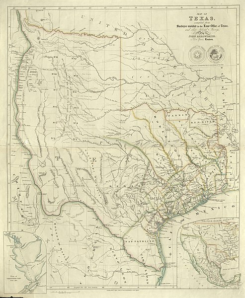
English: Map of Texas compiled from Surveys recorded in the Land Office of Texas and other official Surveys |
||||||||||||||||||||||||||
| 記述 |
English: John Arrowsmith's 1841 map of Texas was one of the first maps to show the new republic's most ambitious boundaries. These included the lower Rio Grande and not the Nueces River as the southern boundary with Mexico, the upper Rio Grande as the border with Mexican New Mexico, and the "stovepipe" panhandle stretching into what is now Colorado and New Mexico. This map appeared in Arrowsmith's London Atlas of Universal Geography first published in 1841 but other variants were included in his later atlases as well as in William Kennedy's popular travel and guide book Texas: The Rise, Progress and Prospects of the Republic of Texas, also published in 1841. Arrowsmith based his map upon a variety of sources from the republic's General Land Office, maps of competitors, travel accounts, and others. It includes the republic's original twenty-three counties plus additional counties formed up to 1839. Among the latter is a huge Robertson County, named for former empresario and pioneer Sterling Clack Robertson (1785-1842) whose right of claim to settle families in the area had led to a dispute with Stephen F. Austin and his partner Samuel May Williams. Arrowsmith's map was widely copied, notably the quote written across the Llano Estacado area of the panhandle that "This tract of Country explored by Le Grand in 1833 is naturally fertile well wooded & with a fair proportion of water" – a reference to Santa Fe trader Alexander Le Grand (ca.1794-1839) who purportedly surveyed the Wilson-Exter empresario grant before Texas became a republic. |
||||||||||||||||||||||||||
| 日付 | |||||||||||||||||||||||||||
| 原典 | UTA Libraries Cartographic Connections: 地図 / テキスト | ||||||||||||||||||||||||||
| 作者 |
|
||||||||||||||||||||||||||
| 受入/取得方法 |
English: The University of Texas at Arlington Libraries Special Collections, Gift of Virginia Garrett |
||||||||||||||||||||||||||
| Geotemporal data | |||||||||||||||||||||||||||
| Map location | テキサス州 | ||||||||||||||||||||||||||
| Georeferencing | If inappropriate please set warp_status = skip to hide. | ||||||||||||||||||||||||||
| Bibliographic data | |||||||||||||||||||||||||||
| 出版物 |
The London Atlas of Universal Geography |
||||||||||||||||||||||||||
| 作者 |
|
||||||||||||||||||||||||||
| 出版地 | ロンドン | ||||||||||||||||||||||||||
| 出版者 |
|
||||||||||||||||||||||||||
| Archival data | |||||||||||||||||||||||||||
| コレクション |
|
||||||||||||||||||||||||||
| 寸法 | 高さ: 62 cm;幅: 52 cm | ||||||||||||||||||||||||||
| 技法 | 彩色された エングレービング / 紙 | ||||||||||||||||||||||||||
| artwork-references |
Streeter, Thomas W. (1983年) Bibliography of Texas 1795-1845 (2nd ed.)、Woodbridge: Research Publications, Inc.、1120A, 1373 番、pp. 371, 438 "Revised and Enlarged by Archibald Hanna" Martin, James C., and Robert S. Martin (1984, reprinted 1999) Maps of Texas and the Southwest, 1513-1900、オースティン: Texas State Historical Association、32 番、pp. 126–127 Gournay, Luke (1995年) Texas Boundaries: Evolution of the State's Counties、カレッジステーション: Texas A&M University Press、pp. 35–41 Raymond Estep (June 15, 2010). Le Grand, Alexander. Handbook of Texas Online. Texas State Historical Association. Retrieved on August 8, 2019. Malcolm D. McLean (June 15, 2010). Robertson, Sterling Clack. Handbook of Texas Online. Texas State Historical Association. Retrieved on August 8, 2019. |
||||||||||||||||||||||||||

ライセンス
[編集]

|
This file was provided to Wikimedia Commons by the University of Texas at Arlington Libraries as part of a cooperation project. The University of Texas at Arlington Libraries is part of the University of Texas at Arlington, a public research university located in Arlington, Texas.
|
|
著作者が1873年に死亡しているため、この著作物は、著作権の保護期間が著作者の死後100年以下である国・地域においてパブリックドメインの状態にあります。 この著作物は1929年1月1日以前に公表され、又はアメリカ合衆国著作権局に登録されたため、アメリカ合衆国においてパブリックドメインの状態にあります。 | |
| このファイルは著作権法の既知の制約(隣接権や関連する権利を含む)から自由であると特定されています。 | |
ファイルの履歴
過去の版のファイルを表示するには、その版の日時をクリックしてください。
| 日付と時刻 | サムネイル | 寸法 | 利用者 | コメント | |
|---|---|---|---|---|---|
| 現在の版 | 2019年8月10日 (土) 14:36 | | 12,300 × 14,963 (83.62メガバイト) | Michael Barera (トーク | 投稿記録) | == {{int:filedesc}} == {{Map |title = ''Map of Texas compiled from Surveys recorded in the Land Office of Texas and other official Surveys'' |description = {{en|John Arrowsmith's 1841 map of Texas was one of the first maps to show the new republic's most ambitious boundaries. These included the lower Rio Grande and not the Nueces River as the southern boundary with Mexico, the upper Rio Grande as the border with Mexican New Mexico, and the "stovepipe" panhandle stretching... |
このファイルは上書きできません。
ファイルの使用状況
このファイルを使用しているページはありません。
グローバルなファイル使用状況
以下に挙げる他のウィキがこの画像を使っています:
- en.wikipedia.org での使用状況
- ja.wikipedia.org での使用状況
- ru.wikipedia.org での使用状況