File:Arzviller plan incline 01.jpg
跳至導覽
跳至搜尋

預覽大小:800 × 524 像素。 其他解析度:320 × 209 像素 | 640 × 419 像素 | 1,024 × 670 像素 | 1,280 × 838 像素 | 2,502 × 1,638 像素。
原始檔案 (2,502 × 1,638 像素,檔案大小:1.63 MB,MIME 類型:image/jpeg)
說明
說明
添加單行說明來描述出檔案所代表的內容
| 描述 |
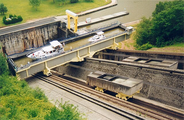
Français : Plan incliné de Saint-Louis-Arzviller
Nederlands: Hellend vlak van St-Louis-Arzviller
English: Saint-Louis-Arzviller inclined plane |
| 日期 | |
| 來源 | Photographie prise par GIRAUD Patrick |
| 作者 | User Calips on fr.wikipedia |
| 授權許可 (重用此檔案) |
此檔案採用共享創意 姓名標示-相同方式分享 1.0 通用版授權條款。
|
| 其他版本 |
Originally from fr.wikipedia; description page was here
|
| 拍攝地點 | | 位於此地的本圖片與其他圖片: OpenStreetMap |
|---|
(Uploaded using CommonsHelper or PushForCommons archive copy at the Wayback Machine)
檔案歷史
點選日期/時間以檢視該時間的檔案版本。
| 日期/時間 | 縮圖 | 尺寸 | 用戶 | 備註 | |
|---|---|---|---|---|---|
| 目前 | 2006年10月31日 (二) 09:07 | | 2,502 × 1,638(1.63 MB) | Korrigan(對話 | 貢獻) | {{Information| |Description= Plan incliné de Saint-Louis-Arzviller Photographie prise par GIRAUD Patrick |Source= |Date= |Author=User Calips on [http://fr.wikipedia.org fr.wikipedia] |Permission={{CC-BY-SA}} |other_versions= Originall |
無法覆蓋此檔案。
檔案用途
下列頁面有用到此檔案:
全域檔案使用狀況
以下其他 wiki 使用了這個檔案:
- als.wikipedia.org 的使用狀況
- cs.wikipedia.org 的使用狀況
- de.wikipedia.org 的使用狀況
- en.wikipedia.org 的使用狀況
- eo.wikipedia.org 的使用狀況
- fr.wikipedia.org 的使用狀況
- Transport fluvial en France
- Canal de la Marne au Rhin
- Plan incliné de Saint-Louis-Arzviller
- Ascenseur à bateaux
- Utilisateur:Calips
- Portail:Lorraine/Lumière
- Portail:Lorraine/Lumière-14
- Wikipédia:Le Bistro/18 juin 2006
- Wikipédia:Le Bistro/Galerie/2006
- Sentier de grande randonnée 532
- Wikipédia:Le Bistro/Galerie/Juin
- 1969 en Lorraine
- fr.wiktionary.org 的使用狀況
- ja.wikipedia.org 的使用狀況
- lb.wikipedia.org 的使用狀況
- nl.wikipedia.org 的使用狀況
- pl.wikipedia.org 的使用狀況
- ru.wikipedia.org 的使用狀況
- sv.wikipedia.org 的使用狀況
- uk.wikipedia.org 的使用狀況
- www.wikidata.org 的使用狀況
- zh.wikipedia.org 的使用狀況