File:Ash Plume from Tavurvur, Papua New Guinea.jpg
跳至導覽
跳至搜尋

預覽大小:534 × 599 像素。 其他解析度:214 × 240 像素 | 428 × 480 像素 | 685 × 768 像素 | 1,183 × 1,327 像素。
原始檔案 (1,183 × 1,327 像素,檔案大小:241 KB,MIME 類型:image/jpeg)
說明
說明
添加單行說明來描述出檔案所代表的內容
摘要
[編輯]
| 描述 |
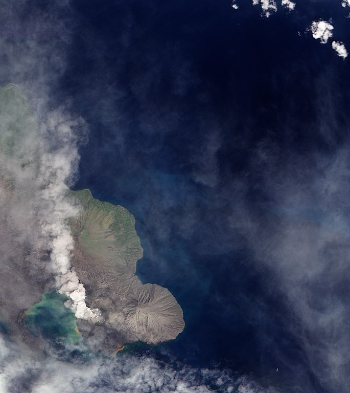
English: A 1994 eruption which buried Rabaul involved the currently active Tavurvur Cone as well as Vulcan Cone, located across Blanche Bay to the south-west (not pictured). The city of Rabaul is located on the peninsula across the Great Harbor from Tavurvur. More than a foot of ash fell on parts of the city, and combined with rain, it collapsed many of the small city’s buildings and houses. White dots on the peninsula may be buildings or building sites. |
| 日期 | |
| 來源 | NASA Earth Observatory |
| 作者 | Robert Simmon |
Image captured by the Advanced Land Imager on NASA’s Earth Observing-1 (EO-1) satellite. Image created using EO-1 ALI data provided by the NASA EO-1 team. Instrument: EO-1 - ALI
授權條款
[編輯]
| 本作品由NASA創作,屬於公有領域。根據NASA的版權政策:“NASA的創作除非另有聲明否則不受版權保護。”(參見:Template:PD-USGov/zh,NASA版權政策或JPL圖像使用政策) | ||
 |
警告:
|
| 註解 | 該圖片含有註解:在維基媒體共享資源上查看註解 |
檔案歷史
點選日期/時間以檢視該時間的檔案版本。
| 日期/時間 | 縮圖 | 尺寸 | 使用者 | 備註 | |
|---|---|---|---|---|---|
| 目前 | 2009年12月8日 (二) 13:04 | | 1,183 × 1,327(241 KB) | Originalwana(留言 | 貢獻) | {{Information |Description={{en|1=A 1994 eruption which buried Rabaul involved the currently active Tavurvur Cone as well as Vulcan Cone, located across Blanche Bay to the south-west (not pictured). The city of Rabaul is located on the peninsula acros |
無法覆蓋此檔案。
檔案用途
下列頁面有用到此檔案:
全域檔案使用狀況
以下其他 wiki 使用了這個檔案:
- br.wikipedia.org 的使用狀況
- en.wikipedia.org 的使用狀況
- fa.wikipedia.org 的使用狀況
- hu.wikipedia.org 的使用狀況
- id.wikipedia.org 的使用狀況
- it.wikipedia.org 的使用狀況
- ja.wikipedia.org 的使用狀況
- ko.wikipedia.org 的使用狀況
- pt.wikipedia.org 的使用狀況
- uk.wikipedia.org 的使用狀況
- zh.wikipedia.org 的使用狀況