File:Atafutrim.jpg
跳去導覽
跳去搵嘢

預覽大細:800 × 566 像素。 第啲解像度:320 × 226 像素 | 640 × 452 像素 | 1,024 × 724 像素 | 1,280 × 905 像素 | 2,088 × 1,476 像素。
原本檔案 (2,088 × 1,476 像素,檔案大細:1.16 MB ,MIME類型:image/jpeg)
Captions
Captions
Add a one-line explanation of what this file represents
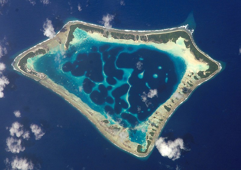
Satellite image of the Atafu Atoll in Tokelau.
| 描述 |
Cropped version of Atafu.jpg
|
| 日期 | (UTC) |
| 來源 | |
| 作者 |
|
| Object location | | View this and other nearby images on: OpenStreetMap |
|---|
| This file is in the public domain in the United States because it was solely created by NASA. NASA copyright policy states that "NASA material is not protected by copyright unless noted". (See Template:PD-USGov, NASA copyright policy page or JPL Image Use Policy.) | ||
 |
Warnings:
|
Original upload log[編輯]
This image is a derivative work of the following images:
- File:Atafu.jpg licensed with PD-USGov-NASA
Uploaded with derivativeFX

|
This image has been assessed under the valued image criteria and is considered the most valued image on Commons within the scope: Atafu atoll, Tokelau - satellite view. You can see its nomination here. |
檔案歷史
撳個日期/時間去睇響嗰個時間出現過嘅檔案。
| 日期/時間 | 縮圖 | 尺寸 | 用戶 | 註解 | |
|---|---|---|---|---|---|
| 現時 | 2009年3月2號 (一) 00:12 | | 2,088 × 1,476(1.16 MB) | Talkstosocks(傾偈 | 貢獻) | {{Information |Description=Cropped version of Atafu.jpg *{{en|Satellite picture of the Atafu atoll in Tokelau.}} *{{es|Imágen de satélite de Atafu.}} *{{de|Satellitenbild des Atafu Atolls in Tokelau.}} |Source=*File:Atafu.jpg |Dat |
你無得衾咗個檔案。
檔案用途
以下嘅5版用到呢個檔:
全域檔案使用情況
下面嘅維基都用緊呢個檔案:
- ace.wikipedia.org嘅使用情況
- als.wikipedia.org嘅使用情況
- ar.wikipedia.org嘅使用情況
- bh.wikipedia.org嘅使用情況
- bn.wikipedia.org嘅使用情況
- bs.wikipedia.org嘅使用情況
- cs.wikipedia.org嘅使用情況
- de.wikipedia.org嘅使用情況
- el.wiktionary.org嘅使用情況
- en.wikipedia.org嘅使用情況
- en.wiktionary.org嘅使用情況
- es.wikipedia.org嘅使用情況
- es.wikibooks.org嘅使用情況
- eu.wikipedia.org嘅使用情況
- fa.wikipedia.org嘅使用情況
- fr.wikipedia.org嘅使用情況
- ga.wikipedia.org嘅使用情況
- he.wikipedia.org嘅使用情況
- hi.wikipedia.org嘅使用情況
- ia.wikipedia.org嘅使用情況
- id.wikipedia.org嘅使用情況
- id.wiktionary.org嘅使用情況
- is.wikipedia.org嘅使用情況
- kbd.wikipedia.org嘅使用情況
- km.wikipedia.org嘅使用情況
- ko.wikipedia.org嘅使用情況
- ku.wiktionary.org嘅使用情況
- la.wikipedia.org嘅使用情況
- lv.wikipedia.org嘅使用情況
- mdf.wikipedia.org嘅使用情況
- mk.wikipedia.org嘅使用情況
- ml.wikipedia.org嘅使用情況
睇呢個檔案嘅更多全域使用情況。