File:Atafutrim.jpg
跳至導覽
跳至搜尋

預覽大小:800 × 566 像素。 其他解析度:320 × 226 像素 | 640 × 452 像素 | 1,024 × 724 像素 | 1,280 × 905 像素 | 2,088 × 1,476 像素。
原始檔案 (2,088 × 1,476 像素,檔案大小:1.16 MB,MIME 類型:image/jpeg)
說明
說明
添加單行說明來描述出檔案所代表的內容
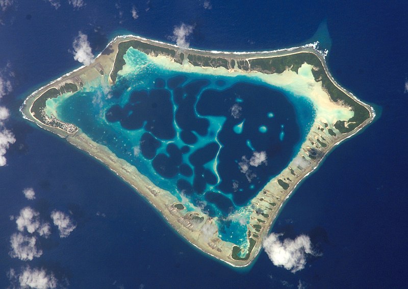
Satellite image of the Atafu Atoll in Tokelau.
| 描述 |
Cropped version of Atafu.jpg
|
| 日期 | (UTC) |
| 來源 | |
| 作者 |
|
| 目標地點 | | 位於此地的本圖片與其他圖片: OpenStreetMap |
|---|
| 本作品由NASA創作,屬於公有領域。根據NASA的版權政策:“NASA的創作除非另有聲明否則不受版權保護。”(參見:Template:PD-USGov/zh,NASA版權政策或JPL圖像使用政策) | ||
 |
警告:
|
原始上傳日誌[編輯]
This image is a derivative work of the following images:
- File:Atafu.jpg licensed with PD-USGov-NASA
Uploaded with derivativeFX

|
根據最有價值圖像標準,這張圖像被評定为在Atafu atoll, Tokelau - satellite view範疇內最有價值的共享資源圖像。你可以在Commons:Valued image candidates/Atafutrim.jpg参看它的提名。 |
檔案歷史
點選日期/時間以檢視該時間的檔案版本。
| 日期/時間 | 縮圖 | 尺寸 | 用戶 | 備註 | |
|---|---|---|---|---|---|
| 目前 | 2009年3月2日 (一) 00:12 | | 2,088 × 1,476(1.16 MB) | Talkstosocks(對話 | 貢獻) | {{Information |Description=Cropped version of Atafu.jpg *{{en|Satellite picture of the Atafu atoll in Tokelau.}} *{{es|Imágen de satélite de Atafu.}} *{{de|Satellitenbild des Atafu Atolls in Tokelau.}} |Source=*File:Atafu.jpg |Dat |
無法覆蓋此檔案。
檔案用途
下列5個頁面有用到此檔案:
全域檔案使用狀況
以下其他 wiki 使用了這個檔案:
- ace.wikipedia.org 的使用狀況
- als.wikipedia.org 的使用狀況
- ar.wikipedia.org 的使用狀況
- bh.wikipedia.org 的使用狀況
- bn.wikipedia.org 的使用狀況
- bs.wikipedia.org 的使用狀況
- cs.wikipedia.org 的使用狀況
- de.wikipedia.org 的使用狀況
- el.wiktionary.org 的使用狀況
- en.wikipedia.org 的使用狀況
- en.wiktionary.org 的使用狀況
- es.wikipedia.org 的使用狀況
- es.wikibooks.org 的使用狀況
- eu.wikipedia.org 的使用狀況
- fa.wikipedia.org 的使用狀況
- fr.wikipedia.org 的使用狀況
- ga.wikipedia.org 的使用狀況
- he.wikipedia.org 的使用狀況
- hi.wikipedia.org 的使用狀況
- ia.wikipedia.org 的使用狀況
- id.wikipedia.org 的使用狀況
- id.wiktionary.org 的使用狀況
- is.wikipedia.org 的使用狀況
- kbd.wikipedia.org 的使用狀況
- km.wikipedia.org 的使用狀況
- ko.wikipedia.org 的使用狀況
- ku.wiktionary.org 的使用狀況
- la.wikipedia.org 的使用狀況
- lv.wikipedia.org 的使用狀況
- mdf.wikipedia.org 的使用狀況
- mk.wikipedia.org 的使用狀況
- ml.wikipedia.org 的使用狀況
檢視此檔案的更多全域使用狀況。