File:Atlantic-city-nj-map.png
跳去導覽
跳去搵嘢
冇更高解像度嘅圖像。
Atlantic-city-nj-map.png (575 × 425 像素,檔案大細:47 KB ,MIME類型:image/png)
Captions
Captions
Add a one-line explanation of what this file represents
摘要
[編輯]
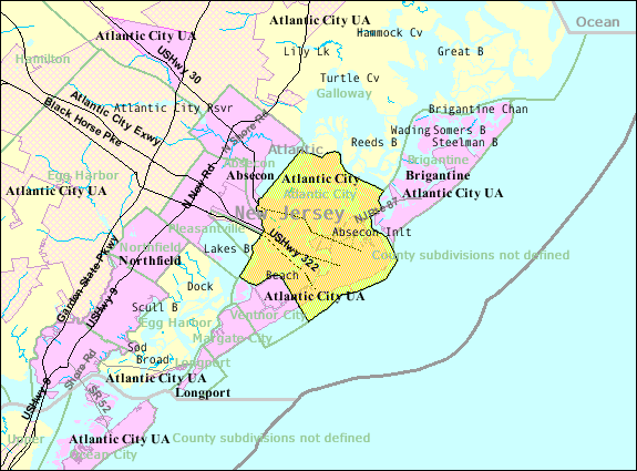
| 描述 | U.S. Census 2000 reference map for Atlantic City, New Jersey |
| 日期 | |
| 來源 | http://factfinder.census.gov |
| 作者 | United States Census Bureau |
| 許可 (重用呢個檔案) |
Public domain |
協議
[編輯]
This image or file is a work of a United States Census Bureau employee, taken or made as part of that person's official duties. As a work of the U.S. federal government, the image is in the public domain.
|
 |
Original upload log
[編輯]
Transferred from en.wikipedia to Commons using FtCG.
The original description page was here. All following user names refer to en.wikipedia.
| Date/Time | Dimensions | User | Comment |
|---|---|---|---|
| 15:17, 30 October 2007 | 575 × 425 (50,641 bytes) | w:en:Americasroof (傾偈 | 貢獻) | ([[Atlantic City, New Jersey]] map from U.S. Census) |
Original upload log
[編輯]
| 日期/時間 | 尺寸 | 用戶 | 註解 |
|---|---|---|---|
| 2012年1月5號, 15:05:36 | 575 × 425 (50641 bytes) | This is also Sven Manguard (傾偈 · 貢獻) | Transferred from en.wikipedia: see original upload log above |
檔案歷史
撳個日期/時間去睇響嗰個時間出現過嘅檔案。
| 日期/時間 | 縮圖 | 尺寸 | 用戶 | 註解 | |
|---|---|---|---|---|---|
| 現時 | 2014年8月18號 (一) 15:22 | | 575 × 425(47 KB) | GifTagger(傾偈 | 貢獻) | Bot: Converting file to superior PNG file. (Source: Atlantic-city-nj-map.gif). This GIF was problematic due to non-greyscale color table. |
你無得衾咗個檔案。
檔案用途
以下嘅1版用到呢個檔:
全域檔案使用情況
下面嘅維基都用緊呢個檔案:
- fa.wikipedia.org嘅使用情況
- ja.wikipedia.org嘅使用情況
- ko.wikipedia.org嘅使用情況
- ro.wikipedia.org嘅使用情況
- sco.wikipedia.org嘅使用情況
- simple.wikipedia.org嘅使用情況
- ur.wikipedia.org嘅使用情況
- zh-yue.wikipedia.org嘅使用情況